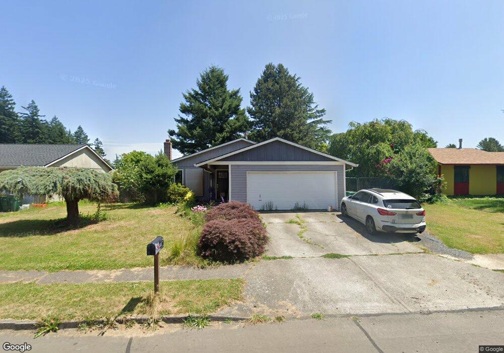
2242 SW Brink Ave Troutdale, OR 97060
Town Center NeighborhoodEstimated Value: $415,000 - $450,000
3
Beds
2
Baths
1,236
Sq Ft
$350/Sq Ft
Est. Value
About This Home
This home is located at 2242 SW Brink Ave, Troutdale, OR 97060 and is currently estimated at $432,420, approximately $349 per square foot. 2242 SW Brink Ave is a home located in Multnomah County with nearby schools including Woodland Elementary School, Walt Morey Middle School, and Reynolds High School.
Ownership History
Date
Name
Owned For
Owner Type
Purchase Details
Closed on
Nov 16, 2018
Sold by
Hedden Keir A
Bought by
Hedden Julie Kathleen
Current Estimated Value
Home Financials for this Owner
Home Financials are based on the most recent Mortgage that was taken out on this home.
Original Mortgage
$211,000
Outstanding Balance
$185,547
Interest Rate
4.9%
Mortgage Type
New Conventional
Estimated Equity
$246,873
Purchase Details
Closed on
Jun 2, 2004
Sold by
Household Finance Corp Ii
Bought by
Hedden Keir A and Hedden Julie K
Home Financials for this Owner
Home Financials are based on the most recent Mortgage that was taken out on this home.
Original Mortgage
$120,800
Interest Rate
6.29%
Mortgage Type
Purchase Money Mortgage
Purchase Details
Closed on
Feb 27, 2004
Sold by
Pulicella Joe A
Bought by
Household Finance Corp Ii
Create a Home Valuation Report for This Property
The Home Valuation Report is an in-depth analysis detailing your home's value as well as a comparison with similar homes in the area
Home Values in the Area
Average Home Value in this Area
Purchase History
| Date | Buyer | Sale Price | Title Company |
|---|---|---|---|
| Hedden Julie Kathleen | -- | Old Republic Title Co | |
| Hedden Keir A | $151,000 | Transnation Title Agency Or | |
| Household Finance Corp Ii | $141,000 | Fidelity National Title Co |
Source: Public Records
Mortgage History
| Date | Status | Borrower | Loan Amount |
|---|---|---|---|
| Open | Hedden Julie Kathleen | $211,000 | |
| Closed | Hedden Keir A | $120,800 | |
| Closed | Hedden Keir A | $30,200 |
Source: Public Records
Tax History Compared to Growth
Tax History
| Year | Tax Paid | Tax Assessment Tax Assessment Total Assessment is a certain percentage of the fair market value that is determined by local assessors to be the total taxable value of land and additions on the property. | Land | Improvement |
|---|---|---|---|---|
| 2025 | $3,926 | $211,820 | -- | -- |
| 2024 | $3,711 | $205,660 | -- | -- |
| 2023 | $3,614 | $199,670 | $0 | $0 |
| 2022 | $3,527 | $193,860 | $0 | $0 |
| 2021 | $3,445 | $188,220 | $0 | $0 |
| 2020 | $3,220 | $182,740 | $0 | $0 |
| 2019 | $3,092 | $177,420 | $0 | $0 |
| 2018 | $3,071 | $172,260 | $0 | $0 |
| 2017 | $3,064 | $167,250 | $0 | $0 |
| 2016 | $2,962 | $162,380 | $0 | $0 |
| 2015 | $2,889 | $157,660 | $0 | $0 |
| 2014 | $2,809 | $153,070 | $0 | $0 |
Source: Public Records
Map
Nearby Homes
- 2701 SW Latourell Place
- 1427 SW 24th St
- 1953 SW Northstar Way
- 1330 SW 28th St Unit 1332
- 24044 NE Treehill Dr Unit 6
- 1021 SW 24th St
- 2846 SW Faith Ct
- 23882 NE Treehill Dr Unit T3882
- 1106 SW Dottie Ct
- 2701 NE Hale Ave
- 1422 SW 11th St
- 1556 NE 27th Terrace
- 114 Maple Blvd
- 821 SW 14th St
- 3248 NE 29th St Unit 31
- 724 SW 28th St
- 3300 NE 29th St Unit 28
- 3240 NE 29th St
- 3230 NE 29th St Unit 40
- 1575 NE 237th Ave Unit 1577
- 2236 SW Brink Ave
- 2248 SW Brink Ave
- 2223 SW Dunbar Place
- 2235 SW Dunbar Place
- 2245 SW Brink Ave
- 2234 SW Brink Ave
- 2249 SW Brink Ave
- 2239 SW Brink Ave
- 2122 SW 22nd Ct
- 2251 SW Brink Ave
- 2114 SW 22nd Ct
- 2233 SW Brink Ave
- 2216 SW 23rd St
- 2228 SW Brink Ave
- 2325 SW Dunbar Place
- 2237 SW 23rd St
- 2225 SW Brink Ave
- 2125 SW 22nd Ct
- 2312 SW 22nd St
- 2220 SW 23rd St