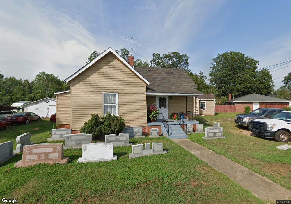
225 Lide Fant Ave Anderson, SC 29624
Estimated Value: $55,194 - $180,000
--
Bed
--
Bath
520
Sq Ft
$214/Sq Ft
Est. Value
About This Home
This home is located at 225 Lide Fant Ave, Anderson, SC 29624 and is currently estimated at $111,049, approximately $213 per square foot. 225 Lide Fant Ave is a home located in Anderson County with nearby schools including Varennes Elementary School, McCants Middle School, and T.L. Hanna High School.
Ownership History
Date
Name
Owned For
Owner Type
Purchase Details
Closed on
Apr 8, 2020
Sold by
Payne David L and Payne Theresa E
Bought by
Gravvanis Vasilis N
Current Estimated Value
Purchase Details
Closed on
Oct 5, 2006
Sold by
Burton Barbara E
Bought by
Payne David L and Payne Theresa E
Home Financials for this Owner
Home Financials are based on the most recent Mortgage that was taken out on this home.
Original Mortgage
$49,625
Interest Rate
6.45%
Mortgage Type
Purchase Money Mortgage
Create a Home Valuation Report for This Property
The Home Valuation Report is an in-depth analysis detailing your home's value as well as a comparison with similar homes in the area
Home Values in the Area
Average Home Value in this Area
Purchase History
| Date | Buyer | Sale Price | Title Company |
|---|---|---|---|
| Gravvanis Vasilis N | $50,000 | None Available | |
| Payne David L | $37,500 | None Available |
Source: Public Records
Mortgage History
| Date | Status | Borrower | Loan Amount |
|---|---|---|---|
| Previous Owner | Payne David L | $49,625 |
Source: Public Records
Tax History Compared to Growth
Tax History
| Year | Tax Paid | Tax Assessment Tax Assessment Total Assessment is a certain percentage of the fair market value that is determined by local assessors to be the total taxable value of land and additions on the property. | Land | Improvement |
|---|---|---|---|---|
| 2024 | $695 | $1,840 | $310 | $1,530 |
| 2023 | $695 | $1,840 | $310 | $1,530 |
| 2022 | $651 | $1,840 | $310 | $1,530 |
| 2021 | $620 | $1,610 | $230 | $1,380 |
| 2020 | $602 | $1,610 | $230 | $1,380 |
| 2019 | $602 | $1,610 | $230 | $1,380 |
| 2018 | $595 | $1,610 | $230 | $1,380 |
| 2017 | -- | $1,610 | $230 | $1,380 |
| 2016 | $604 | $1,650 | $180 | $1,470 |
| 2015 | $607 | $1,650 | $180 | $1,470 |
| 2014 | $595 | $1,650 | $180 | $1,470 |
Source: Public Records
Map
Nearby Homes
- 122 Avondale Rd
- 2318 S Mcduffie St
- 46 S Lyons St
- 114 Dixie Dr
- 112 Dixie Dr
- 110 Dixie Dr
- 16 N Prince St
- 329 Sherman Dr
- 421 Valentine St
- 6 Herring Ave
- 1709 Lyndon Ave
- 705 Woodmont Cir
- 1609 Lyndon Ave
- 1619 Nardin Ave
- 1616 Meadowbrook Cir
- 1609 S Mcduffie St
- 313 Hugh St
- 815 Winston Dr
- 1606 S Murray Avenue Extension
- 505 Woodmont Cir
- 223 Lida Fant Ave
- 205 E Shockley Ferry Rd
- 127 E Shockley Ferry Rd
- 219 Lida Fant Ave
- 219 Lide Fant Ave
- 217 Lide Fant Ave
- 206 Lida Fant Ave
- 206 E Shockley Ferry Rd
- 104 Avondale Rd
- 208 E Shockley Ferry Rd
- 213 E Shockley Ferry Rd
- 214 Lida Fant Ave
- 106 Avondale Rd
- 210 E Shockley Ferry Rd
- 107 Avondale Rd
- 108 Avondale Rd
- 1307 Coe Rd
- 212 E Shockley Ferry Rd
- 117A E Shockley Ferry Rd
- 217 E Shockley Ferry Rd