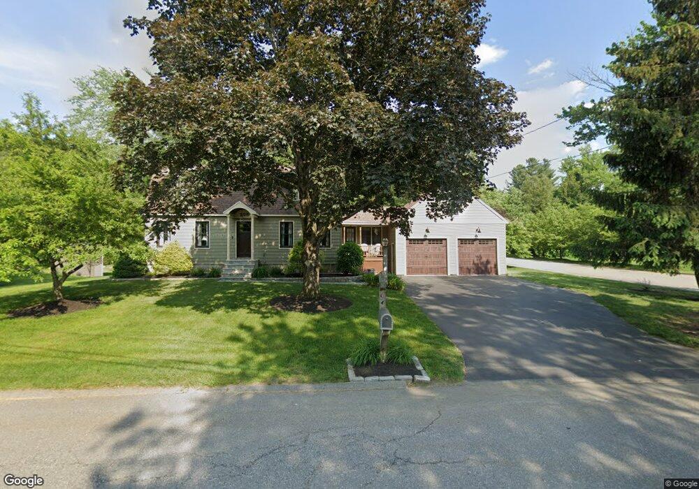
225 Patricia Ln Dracut, MA 01826
Estimated Value: $654,784 - $768,000
3
Beds
2
Baths
2,064
Sq Ft
$336/Sq Ft
Est. Value
About This Home
This home is located at 225 Patricia Ln, Dracut, MA 01826 and is currently estimated at $693,446, approximately $335 per square foot. 225 Patricia Ln is a home located in Middlesex County with nearby schools including George H. Englesby Elementary School, Richardson Middle School, and Dracut Senior High School.
Ownership History
Date
Name
Owned For
Owner Type
Purchase Details
Closed on
Oct 8, 2019
Sold by
Jusczak Richard and Jusczak Erika E
Bought by
Jusczak Irt 2019
Current Estimated Value
Purchase Details
Closed on
Jun 27, 1978
Bought by
Jusczak Richard and Jusczak Erika E
Create a Home Valuation Report for This Property
The Home Valuation Report is an in-depth analysis detailing your home's value as well as a comparison with similar homes in the area
Home Values in the Area
Average Home Value in this Area
Purchase History
| Date | Buyer | Sale Price | Title Company |
|---|---|---|---|
| Jusczak Irt 2019 | -- | -- | |
| Jusczak Richard | -- | -- |
Source: Public Records
Mortgage History
| Date | Status | Borrower | Loan Amount |
|---|---|---|---|
| Previous Owner | Jusczak Richard | $105,000 | |
| Previous Owner | Jusczak Richard | $75,000 | |
| Previous Owner | Jusczak Richard | $70,000 | |
| Previous Owner | Jusczak Richard | $15,000 |
Source: Public Records
Tax History Compared to Growth
Tax History
| Year | Tax Paid | Tax Assessment Tax Assessment Total Assessment is a certain percentage of the fair market value that is determined by local assessors to be the total taxable value of land and additions on the property. | Land | Improvement |
|---|---|---|---|---|
| 2025 | $5,450 | $538,500 | $209,000 | $329,500 |
| 2024 | $5,435 | $520,100 | $199,100 | $321,000 |
| 2023 | $5,261 | $454,300 | $173,100 | $281,200 |
| 2022 | $5,156 | $419,500 | $157,300 | $262,200 |
| 2021 | $4,971 | $382,100 | $142,900 | $239,200 |
| 2020 | $4,810 | $360,300 | $138,700 | $221,600 |
| 2019 | $4,594 | $334,100 | $132,000 | $202,100 |
| 2018 | $4,600 | $325,300 | $132,000 | $193,300 |
| 2017 | $4,563 | $325,300 | $132,000 | $193,300 |
| 2016 | $4,437 | $299,000 | $126,900 | $172,100 |
| 2015 | $4,279 | $286,600 | $126,900 | $159,700 |
| 2014 | $4,118 | $284,200 | $126,900 | $157,300 |
Source: Public Records
Map
Nearby Homes
- 50 Stephen Ave
- 35 Camilla Ave
- 10 Edwards St
- 1905 Lakeview Ave
- 9 Cornstalk Ln
- 17 Spare St
- 83 Turgeon Ave
- 53 Vinal St
- 97 Passaconaway Dr
- 73 Mammoth Rd Unit A&B
- 73 Mammoth Rd
- 73 A&B Mammoth Rd
- 999 Hildreth St
- 29 Mill St Unit B
- 74 Tennis Plaza Rd Unit 34
- 124 Tennis Plaza Rd Unit 22
- 94 Tennis Plaza Rd Unit 10
- 84 Tennis Plaza Rd Unit 64
- 53 4th St
- 29 Wimbledon Crossing
- 235 Patricia Ln
- 211 Patricia Ln
- 8 Mullen Ln
- 245 Patricia Ln
- 234 Patricia Ln
- 201 Patricia Ln
- 252 Patricia Ln
- 22 Mullen Ln
- 5 Quincy Ave
- 69 Kings Field Rd
- 255 Patricia Ln
- 60 Kings Field Rd
- 60 Kingsfield Rd
- 264 Patricia Ln
- 191 Patricia Ln
- 19 Mullen Ln
- 32 Mullen Ln
- 61 Kings Field Rd
- 15 Quincy Ave
- 200 Patricia Ln