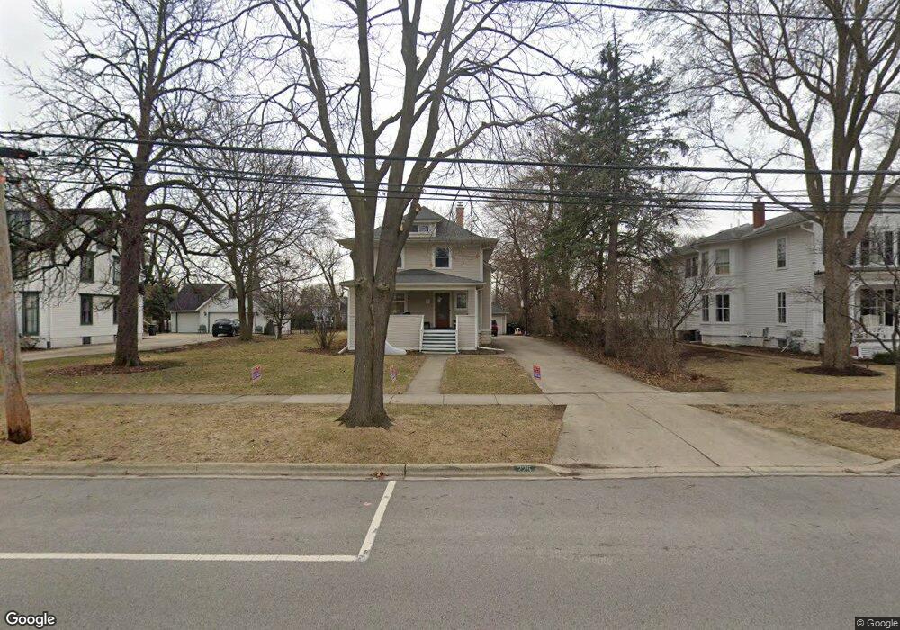
225 W Maple St Lombard, IL 60148
North Lombard NeighborhoodEstimated Value: $607,088 - $704,000
--
Bed
--
Bath
2,476
Sq Ft
$260/Sq Ft
Est. Value
About This Home
This home is located at 225 W Maple St, Lombard, IL 60148 and is currently estimated at $642,522, approximately $259 per square foot. 225 W Maple St is a home located in DuPage County with nearby schools including Madison Elementary School, Pleasant Lane Elementary School, and Park View Elementary School.
Ownership History
Date
Name
Owned For
Owner Type
Purchase Details
Closed on
Nov 10, 2021
Sold by
Avila John G and Avila Margaret S
Bought by
Packer Andrew William and Packer Roxanne
Current Estimated Value
Home Financials for this Owner
Home Financials are based on the most recent Mortgage that was taken out on this home.
Original Mortgage
$342,100
Interest Rate
3.56%
Mortgage Type
New Conventional
Purchase Details
Closed on
Aug 16, 1996
Sold by
Keil Daniel Charles and Keil Joanne M
Bought by
Avila John G and Avila Margaret S
Home Financials for this Owner
Home Financials are based on the most recent Mortgage that was taken out on this home.
Original Mortgage
$122,000
Interest Rate
8.18%
Purchase Details
Closed on
Jun 20, 1996
Sold by
Keil Daniel C and Keil Joanne
Bought by
Keil Daniel C and Keil Joanne
Home Financials for this Owner
Home Financials are based on the most recent Mortgage that was taken out on this home.
Original Mortgage
$122,000
Interest Rate
8.18%
Create a Home Valuation Report for This Property
The Home Valuation Report is an in-depth analysis detailing your home's value as well as a comparison with similar homes in the area
Home Values in the Area
Average Home Value in this Area
Purchase History
| Date | Buyer | Sale Price | Title Company |
|---|---|---|---|
| Packer Andrew William | $488,000 | Citywide Title | |
| Avila John G | $152,500 | -- | |
| Keil Daniel C | -- | -- |
Source: Public Records
Mortgage History
| Date | Status | Borrower | Loan Amount |
|---|---|---|---|
| Previous Owner | Packer Andrew William | $342,100 | |
| Previous Owner | Avila John G | $122,000 |
Source: Public Records
Tax History Compared to Growth
Tax History
| Year | Tax Paid | Tax Assessment Tax Assessment Total Assessment is a certain percentage of the fair market value that is determined by local assessors to be the total taxable value of land and additions on the property. | Land | Improvement |
|---|---|---|---|---|
| 2024 | $13,596 | $182,994 | $30,149 | $152,845 |
| 2023 | $12,965 | $169,220 | $27,880 | $141,340 |
| 2022 | $12,502 | $162,670 | $26,800 | $135,870 |
| 2021 | $12,226 | $164,990 | $26,130 | $138,860 |
| 2020 | $11,968 | $161,380 | $25,560 | $135,820 |
| 2019 | $11,363 | $153,430 | $24,300 | $129,130 |
| 2018 | $11,094 | $144,670 | $42,500 | $102,170 |
| 2017 | $10,774 | $137,860 | $40,500 | $97,360 |
| 2016 | $10,470 | $129,870 | $38,150 | $91,720 |
| 2015 | $10,330 | $120,990 | $35,540 | $85,450 |
| 2014 | $8,763 | $100,700 | $43,630 | $57,070 |
| 2013 | $8,626 | $102,110 | $44,240 | $57,870 |
Source: Public Records
Map
Nearby Homes
- 1 S Lincoln Ave Unit 301
- 337 S Brewster Ave
- 407 S Brewster Ave
- 465 S Elizabeth St
- 49 Orchard Terrace Unit 1
- 78 N Elizabeth St
- 107 S Charlotte St
- 250 St Regis
- 33 N Main St Unit 11A
- 408 S Miller Ct
- 105 E Grove St
- 555 W Saint Charles Rd
- 313 S Lombard Ave
- 328 S Grace St
- 6 W Harding Rd
- 635 S Charlotte St
- 220 N Martha St
- 610 Hammerschmidt Ave
- 260 N Charlotte St
- 206 Troy Ln