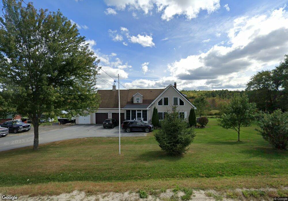
225 Woodman Rd New Gloucester, ME 04260
Estimated Value: $545,000 - $576,006
2
Beds
1
Bath
1,428
Sq Ft
$392/Sq Ft
Est. Value
About This Home
This home is located at 225 Woodman Rd, New Gloucester, ME 04260 and is currently estimated at $559,335, approximately $391 per square foot. 225 Woodman Rd is a home located in Cumberland County with nearby schools including Gray-New Gloucester High School.
Ownership History
Date
Name
Owned For
Owner Type
Purchase Details
Closed on
Jul 9, 2007
Sold by
Donovan Jeremiah S and Donovan Diane C
Bought by
Curtis David and Curtis Veronica
Current Estimated Value
Home Financials for this Owner
Home Financials are based on the most recent Mortgage that was taken out on this home.
Original Mortgage
$325,000
Outstanding Balance
$203,867
Interest Rate
6.75%
Mortgage Type
Unknown
Estimated Equity
$355,468
Create a Home Valuation Report for This Property
The Home Valuation Report is an in-depth analysis detailing your home's value as well as a comparison with similar homes in the area
Home Values in the Area
Average Home Value in this Area
Purchase History
| Date | Buyer | Sale Price | Title Company |
|---|---|---|---|
| Curtis David | -- | -- |
Source: Public Records
Mortgage History
| Date | Status | Borrower | Loan Amount |
|---|---|---|---|
| Open | Curtis David | $30,000 | |
| Open | Curtis David | $150,000 | |
| Open | Curtis David | $325,000 |
Source: Public Records
Tax History Compared to Growth
Tax History
| Year | Tax Paid | Tax Assessment Tax Assessment Total Assessment is a certain percentage of the fair market value that is determined by local assessors to be the total taxable value of land and additions on the property. | Land | Improvement |
|---|---|---|---|---|
| 2025 | $5,701 | $368,496 | $106,351 | $262,145 |
| 2024 | $5,487 | $368,496 | $106,351 | $262,145 |
| 2023 | $5,266 | $368,496 | $106,351 | $262,145 |
| 2022 | $5,085 | $368,496 | $106,351 | $262,145 |
| 2021 | $5,085 | $368,496 | $106,351 | $262,145 |
| 2020 | $5,030 | $368,496 | $106,351 | $262,145 |
| 2019 | $4,068 | $240,700 | $79,100 | $161,600 |
| 2018 | $3,803 | $240,700 | $79,100 | $161,600 |
| 2017 | $3,755 | $240,700 | $79,100 | $161,600 |
| 2016 | $3,538 | $240,700 | $79,100 | $161,600 |
| 2015 | $3,526 | $240,700 | $79,100 | $161,600 |
| 2014 | $3,490 | $240,700 | $79,100 | $161,600 |
| 2013 | $3,237 | $240,700 | $79,100 | $161,600 |
Source: Public Records
Map
Nearby Homes
- 200 Woodman Rd
- 10 Cobbs Bridge Rd
- 160 Gloucester Hill Rd
- 164 Intervale Rd
- 155 & 151 Gloucester Hill Rd
- 0018-C Gloucester Hill Rd
- 12 Country Charm Ln
- 22 Shaw Rd
- 271 Bennett Rd
- 850 Lawrence Rd
- 10-56 C&E Bowdoin Way
- 99 Rangdale Rd
- TBD Targett Rd
- 284 Allen Rd
- 24 Swamp Rd
- 1 Mattie Ln
- 059-007 Soper's Mill Rd
- 244 Allen Rd
- 890 Elmwood Rd
- 026-01 Dow Ln
- 205 Woodman Rd
- 210 Woodman Rd
- 230 Woodman Rd
- 247 Woodman Rd
- TBD Woodman
- 9 Woodman Rd
- 139 Woodman Rd
- 269 Woodman Rd
- 144 Woodman Rd
- 0 Wharrf Road (Off Woodman)
- 0 Wharff Rd Unit 703634
- 0 Warff Rd Unit 1078869
- 0 Wharff Rd Unit 1207458
- 283 Woodman Rd
- 80 Wharff Rd
- TBD Wharf Rd
- 295 Woodman Rd
- 160 Wharff Rd
- 49B Durham Rd
- 49 Durham Rd