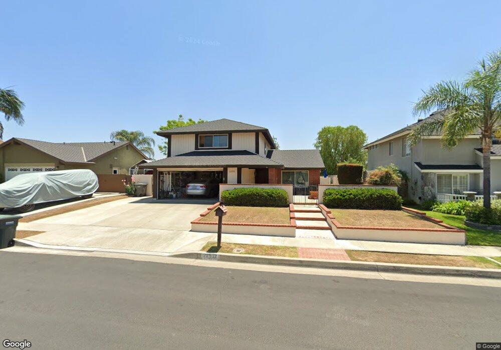
22532 Auburn Dale Dr Lake Forest, CA 92630
Estimated Value: $1,212,953 - $1,255,000
4
Beds
3
Baths
1,829
Sq Ft
$676/Sq Ft
Est. Value
About This Home
This home is located at 22532 Auburn Dale Dr, Lake Forest, CA 92630 and is currently estimated at $1,237,238, approximately $676 per square foot. 22532 Auburn Dale Dr is a home located in Orange County with nearby schools including La Madera Elementary School, Los Alisos Intermediate School, and El Toro High School.
Ownership History
Date
Name
Owned For
Owner Type
Purchase Details
Closed on
Nov 1, 2023
Sold by
Curtis Family Revocable Trust
Bought by
Curtis Family Revocable Trust and Curtis
Current Estimated Value
Purchase Details
Closed on
Feb 17, 2023
Sold by
Curtis Richard D and Curtis Marcia A
Bought by
Curtis Family Revocable Trust
Purchase Details
Closed on
Aug 17, 2022
Sold by
Curtis Richard D and Curtis Marcia A
Bought by
Curtis Richard D and Curtis Marcia A
Create a Home Valuation Report for This Property
The Home Valuation Report is an in-depth analysis detailing your home's value as well as a comparison with similar homes in the area
Home Values in the Area
Average Home Value in this Area
Purchase History
| Date | Buyer | Sale Price | Title Company |
|---|---|---|---|
| Curtis Family Revocable Trust | -- | None Listed On Document | |
| Curtis Family Revocable Trust | -- | -- | |
| Curtis Richard D | -- | Emge Holly M |
Source: Public Records
Tax History Compared to Growth
Tax History
| Year | Tax Paid | Tax Assessment Tax Assessment Total Assessment is a certain percentage of the fair market value that is determined by local assessors to be the total taxable value of land and additions on the property. | Land | Improvement |
|---|---|---|---|---|
| 2025 | $2,968 | $288,654 | $139,099 | $149,555 |
| 2024 | $2,968 | $282,995 | $136,372 | $146,623 |
| 2023 | $2,827 | $277,447 | $133,698 | $143,749 |
| 2022 | $2,775 | $272,007 | $131,076 | $140,931 |
| 2021 | $2,719 | $266,674 | $128,506 | $138,168 |
| 2020 | $2,694 | $263,940 | $127,188 | $136,752 |
| 2019 | $2,639 | $258,765 | $124,694 | $134,071 |
| 2018 | $2,588 | $253,692 | $122,249 | $131,443 |
| 2017 | $2,535 | $248,718 | $119,852 | $128,866 |
| 2016 | $2,492 | $243,842 | $117,502 | $126,340 |
| 2015 | $2,461 | $240,180 | $115,737 | $124,443 |
| 2014 | $2,406 | $235,476 | $113,470 | $122,006 |
Source: Public Records
Map
Nearby Homes
- 22461 Silver Spur
- 25885 Trabuco Rd Unit 206
- 25885 Trabuco Rd Unit 91
- 25885 Trabuco Rd Unit 306
- 25885 Trabuco Rd Unit 33
- 25885 Trabuco Rd Unit 226
- 25885 Trabuco Rd Unit 271
- 25614 Mont Pointe Unit 3D
- 25644 Mont Pointe Unit 1A
- 22201 Center Pointe Unit 2D
- 25631 Mont Pointe Unit 7D
- 22718 Via Castilla
- 25671 Le Parc Unit 85
- 25671 Le Parc Unit 82
- 25712 Le Parc Unit 7
- 26242 Brookhollow
- 25761 Le Parc Unit 82
- 25761 Le Parc Unit 89
- 26025 Via Pera Unit J3
- 26158 Via Pera Unit E4
- 22542 Auburn Dale Dr
- 22522 Auburn Dale Dr
- 22561 Marylhurst Ct
- 22571 Marylhurst Ct
- 22552 Auburn Dale Dr
- 22516 Auburn Dale Dr
- 22581 Marylhurst Ct
- 22551 Marylhurst Ct
- 22531 Auburn Dale Dr
- 22541 Auburn Dale Dr
- 22521 Auburn Dale Dr
- 22562 Auburn Dale Dr
- 22551 Auburn Dale Dr
- 22512 Auburn Dale Dr
- 25822 Chapel Hill Dr
- 22515 Auburn Dale Dr
- 22561 Auburn Dale Dr
- 22601 Marylhurst Ct
- 25832 Chapel Hill Dr
- 22572 Auburn Dale Dr