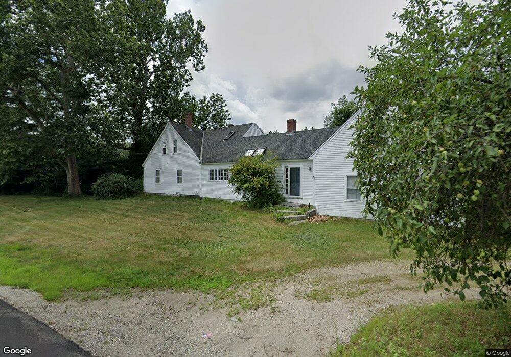
226 S Merrimack Rd Hollis, NH 03049
Hollis NeighborhoodEstimated Value: $650,133 - $735,000
4
Beds
1
Bath
2,370
Sq Ft
$287/Sq Ft
Est. Value
About This Home
This home is located at 226 S Merrimack Rd, Hollis, NH 03049 and is currently estimated at $679,533, approximately $286 per square foot. 226 S Merrimack Rd is a home with nearby schools including Hollis Primary School, Hollis Upper Elementary School, and Hollis-Brookline Middle School.
Ownership History
Date
Name
Owned For
Owner Type
Purchase Details
Closed on
Sep 10, 2021
Sold by
Boghigian Hary C Est
Bought by
Boghigian Carlene
Current Estimated Value
Purchase Details
Closed on
Sep 9, 1986
Bought by
Boghigian Carlene L and Boghigian Harry C
Create a Home Valuation Report for This Property
The Home Valuation Report is an in-depth analysis detailing your home's value as well as a comparison with similar homes in the area
Home Values in the Area
Average Home Value in this Area
Purchase History
| Date | Buyer | Sale Price | Title Company |
|---|---|---|---|
| Boghigian Carlene | -- | None Available | |
| Boghigian Carlene L | -- | -- |
Source: Public Records
Mortgage History
| Date | Status | Borrower | Loan Amount |
|---|---|---|---|
| Previous Owner | Boghigian Carlene L | $250,000 | |
| Previous Owner | Boghigian Carlene L | $630,266 |
Source: Public Records
Tax History Compared to Growth
Tax History
| Year | Tax Paid | Tax Assessment Tax Assessment Total Assessment is a certain percentage of the fair market value that is determined by local assessors to be the total taxable value of land and additions on the property. | Land | Improvement |
|---|---|---|---|---|
| 2024 | $9,792 | $552,300 | $220,800 | $331,500 |
| 2023 | $9,201 | $552,300 | $220,800 | $331,500 |
| 2022 | $12,465 | $552,300 | $220,800 | $331,500 |
| 2021 | $8,780 | $386,800 | $142,700 | $244,100 |
| 2020 | $5,666 | $386,800 | $142,700 | $244,100 |
| 2019 | $5,453 | $386,800 | $142,700 | $244,100 |
| 2018 | $8,382 | $386,800 | $142,700 | $244,100 |
| 2017 | $8,369 | $361,500 | $120,700 | $240,800 |
| 2016 | $4,193 | $361,500 | $120,700 | $240,800 |
| 2015 | $8,322 | $361,500 | $120,700 | $240,800 |
| 2014 | $8,361 | $361,500 | $120,700 | $240,800 |
| 2013 | $8,895 | $389,800 | $149,000 | $240,800 |
Source: Public Records
Map
Nearby Homes
- 77 Mooar Hill Rd
- 8 Pilgrim Cir
- 25 Eastern Ave
- 4-13 Woodmont Dr
- 3 Roedean Dr Unit C-207
- 201 Millwright Dr
- 77 Deerwood Dr Unit E
- 5 Dumaine Ave Unit B
- 5 Dumaine Ave Unit N
- 75 Deerwood Dr Unit B
- 16 Captain Danforth Ln
- 6 Veterans Rd Unit 15
- 10 Drouin Way
- 15 Four Winds Rd
- 66 Tinker Rd
- 199 Pine Hill Rd
- 102 Silver Lake Rd
- 40-40A Pine Hill Rd
- 26 Andover Down Unit 276
- 101-2 Seaverns Bridge Rd