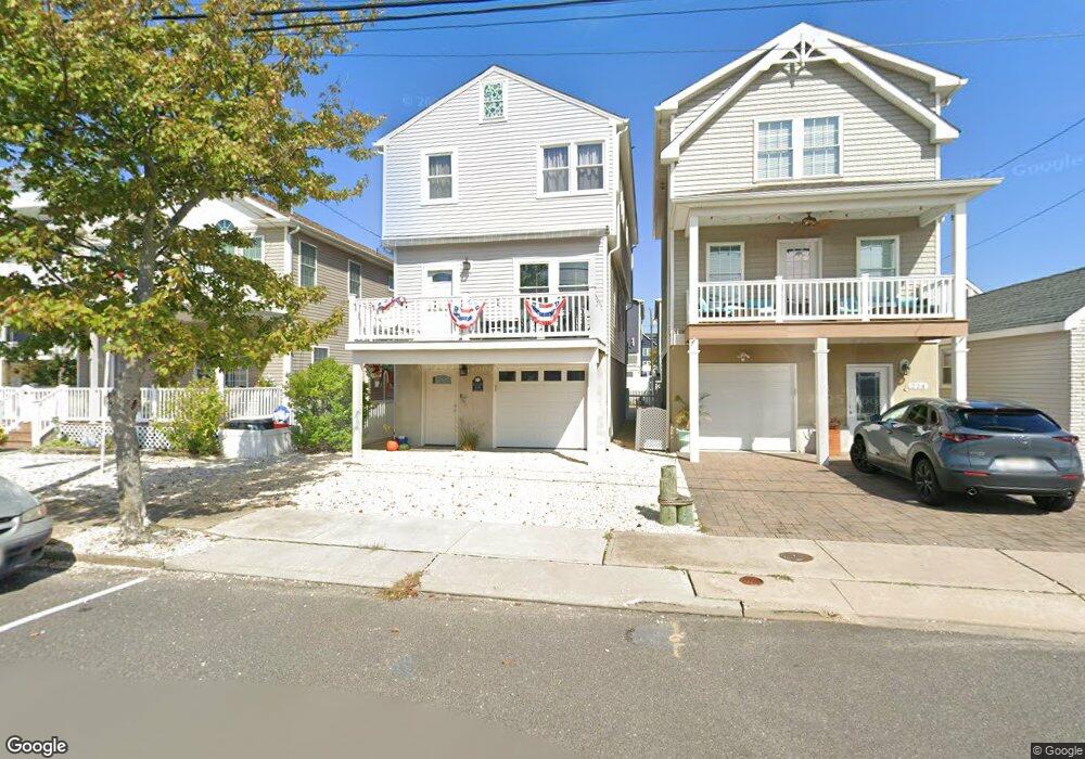
226 Sampson Ave Seaside Heights, NJ 08751
Estimated Value: $570,867 - $889,000
4
Beds
3
Baths
2,360
Sq Ft
$313/Sq Ft
Est. Value
About This Home
This home is located at 226 Sampson Ave, Seaside Heights, NJ 08751 and is currently estimated at $738,217, approximately $312 per square foot. 226 Sampson Ave is a home located in Ocean County with nearby schools including Hugh J. Boyd Jr. Elementary School, Central Regional Middle School, and Central Regional High School.
Ownership History
Date
Name
Owned For
Owner Type
Purchase Details
Closed on
Jul 12, 2013
Sold by
Amabile John and Amabile Mary Ann
Bought by
Leach Richard R and Leach Cheryl A
Current Estimated Value
Home Financials for this Owner
Home Financials are based on the most recent Mortgage that was taken out on this home.
Original Mortgage
$187,480
Outstanding Balance
$135,805
Interest Rate
3.83%
Mortgage Type
New Conventional
Estimated Equity
$602,412
Purchase Details
Closed on
Jul 29, 2011
Sold by
Piccillo Mary Ann
Bought by
Amabile John and Piccillo Mary Ann
Create a Home Valuation Report for This Property
The Home Valuation Report is an in-depth analysis detailing your home's value as well as a comparison with similar homes in the area
Home Values in the Area
Average Home Value in this Area
Purchase History
| Date | Buyer | Sale Price | Title Company |
|---|---|---|---|
| Leach Richard R | $234,350 | Stewart Title Guaranty Co | |
| Amabile John | -- | None Available |
Source: Public Records
Mortgage History
| Date | Status | Borrower | Loan Amount |
|---|---|---|---|
| Open | Leach Richard R | $187,480 |
Source: Public Records
Tax History Compared to Growth
Tax History
| Year | Tax Paid | Tax Assessment Tax Assessment Total Assessment is a certain percentage of the fair market value that is determined by local assessors to be the total taxable value of land and additions on the property. | Land | Improvement |
|---|---|---|---|---|
| 2025 | $9,290 | $727,300 | $389,400 | $337,900 |
| 2024 | $8,621 | $327,800 | $100,500 | $227,300 |
| 2023 | $8,198 | $327,800 | $100,500 | $227,300 |
| 2022 | $8,198 | $327,800 | $100,500 | $227,300 |
| 2021 | $7,933 | $171,300 | $100,500 | $70,800 |
| 2020 | $4,159 | $171,300 | $100,500 | $70,800 |
| 2019 | $4,034 | $171,300 | $100,500 | $70,800 |
| 2018 | $3,928 | $171,300 | $100,500 | $70,800 |
| 2017 | $3,854 | $171,300 | $100,500 | $70,800 |
| 2016 | $3,789 | $171,300 | $100,500 | $70,800 |
| 2015 | $3,657 | $171,300 | $100,500 | $70,800 |
| 2014 | $3,349 | $171,300 | $100,500 | $70,800 |
Source: Public Records
Map
Nearby Homes
- 245 Sampson Ave
- 241 Hiering Ave
- 1501 Central
- 1400 Bay Blvd Unit 1.03 pending
- 1400 Bay Blvd Unit 1.04 pending
- 1400 Bay Blvd Unit 1.02 Pending
- 263 Kearney Ave
- 323 Hiering Ave
- 132 Sampson Ave Unit 2
- 229 Kearney Ave Unit 2
- 211 Kearney Ave
- 118 Sampson Ave
- 228 Hancock Ave
- 112 Kearney Ave
- 122 Fremont Ave
- 1515 Boulevard Unit 4
- 1515 Boulevard Unit 13
- 1601 Boulevard Unit B7
- 1215 Boulevard
- 1201 Ocean Blvd
- 224 Sampson Ave
- 230 Sampson Ave
- 222 Sampson Ave
- 234 Sampson Ave
- 234 Sampson Ave Unit 4
- 206 Sampson Ave
- 220 Sampson Ave
- 218 Sampson Ave
- 227 Hiering Ave
- 225 Hiering Ave
- 229 Hiering Ave
- 223 Hiering Ave
- 231 Hiering Ave
- 221 Hiering Ave
- 216 Sampson Ave
- 233 Hiering Ave
- 233 Hiering Ave Unit 1
- 205 Sampson Ave
- 237 Sampson Ave
- 235 Hiering Ave