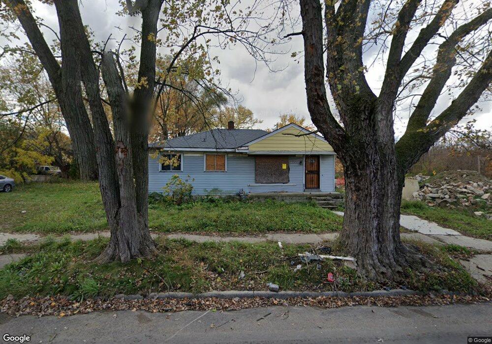
22635 W McNichols Rd Detroit, MI 48219
Riverdale NeighborhoodEstimated Value: $60,000 - $111,698
3
Beds
1
Bath
976
Sq Ft
$86/Sq Ft
Est. Value
About This Home
This home is located at 22635 W McNichols Rd, Detroit, MI 48219 and is currently estimated at $83,675, approximately $85 per square foot. 22635 W McNichols Rd is a home located in Wayne County with nearby schools including Ralph W. Emerson Elementary-Middle School, Charles L. Spain Elementary-Middle School, and Edward 'Duke' Ellington Conservatory of Music and Art.
Ownership History
Date
Name
Owned For
Owner Type
Purchase Details
Closed on
Aug 2, 2022
Sold by
Detroit Land Bank Authority
Bought by
Bolden Industries Inc
Current Estimated Value
Purchase Details
Closed on
Feb 7, 2013
Sold by
Wayne County Treasurer
Bought by
Planning & Development Dept City Of Detr
Purchase Details
Closed on
Mar 11, 2008
Sold by
The Cit Group/Consumer Finance Inc
Bought by
Thomas Lawrence Jay
Purchase Details
Closed on
Apr 18, 2007
Sold by
Smith Peterson Tobi and Peterson Terrell
Bought by
The City Group/Consumer Finance Inc
Purchase Details
Closed on
Apr 9, 2003
Sold by
Hoffman David and Hoffman David Lawrence
Bought by
Smith Peterson Tobi
Create a Home Valuation Report for This Property
The Home Valuation Report is an in-depth analysis detailing your home's value as well as a comparison with similar homes in the area
Home Values in the Area
Average Home Value in this Area
Purchase History
| Date | Buyer | Sale Price | Title Company |
|---|---|---|---|
| Bolden Industries Inc | $5,000 | None Listed On Document | |
| Planning & Development Dept City Of Detr | -- | None Available | |
| Thomas Lawrence Jay | $6,000 | None Available | |
| The City Group/Consumer Finance Inc | $73,300 | None Available | |
| Smith Peterson Tobi | $80,000 | First American Title Ins Co |
Source: Public Records
Tax History Compared to Growth
Tax History
| Year | Tax Paid | Tax Assessment Tax Assessment Total Assessment is a certain percentage of the fair market value that is determined by local assessors to be the total taxable value of land and additions on the property. | Land | Improvement |
|---|---|---|---|---|
| 2025 | $1,144 | $17,400 | $0 | $0 |
| 2024 | $1,144 | $14,900 | $0 | $0 |
| 2023 | $1,110 | $11,305 | $0 | $0 |
| 2022 | $0 | $0 | $0 | $0 |
| 2021 | $0 | $0 | $0 | $0 |
| 2020 | $1,641 | $0 | $0 | $0 |
| 2019 | $1,641 | $0 | $0 | $0 |
| 2018 | $0 | $0 | $0 | $0 |
| 2017 | -- | $0 | $0 | $0 |
| 2016 | $240 | $0 | $0 | $0 |
| 2015 | $1,430 | $0 | $0 | $0 |
| 2013 | $1,430 | $14,302 | $0 | $0 |
| 2010 | -- | $20,492 | $1,038 | $19,454 |
Source: Public Records
Map
Nearby Homes
- 16746 Bramell St
- 22482 W McNichols Rd
- 16816 Lamphere St
- 17121 Redford St #101 St Unit 101
- 17121 Redford St Unit 212
- 16555 Bramell St
- 17161 Redford St Unit 114
- 17161 Redford St Unit 105
- 17161 Redford St
- 16845 Dolphin St
- 16605 Lamphere St
- 17335 Beaverland St
- 17580 Northrop St
- 17770 Redfern St
- 17564 Cooley St
- 17616 Cooley St
- 16753 Burgess
- 15830 Beaverland St
- 15820 Bramell St
- 21652 Orchard St
- 22625 W McNichols Rd
- 22645 W McNichols Rd
- 16898 Beaverland St
- 22661 W McNichols Rd
- 22615 W McNichols Rd
- 16886 Beaverland St
- 16895 Bramell St
- 22603 W McNichols Rd
- 16885 Bramell St
- 16874 Beaverland St
- 22624 W McNichols Rd
- 16875 Bramell St
- 16864 Beaverland St
- 22626 W McNichols Rd
- 22614 W McNichols Rd
- 16865 Bramell St
- 17117 Gore
- 22547 W McNichols Rd
- 22604 W McNichols Rd
- 22666 W McNichols Rd