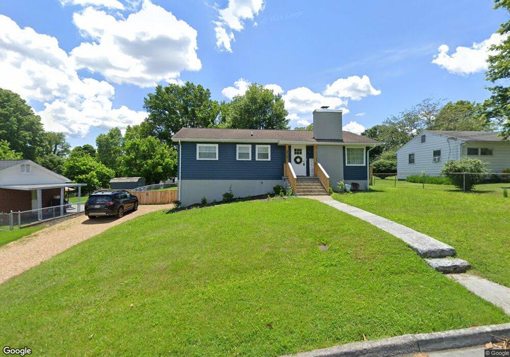
227 Robin Cir Bristol, VA 24202
Estimated Value: $199,000 - $223,928
2
Beds
2
Baths
1,029
Sq Ft
$207/Sq Ft
Est. Value
About This Home
This home is located at 227 Robin Cir, Bristol, VA 24202 and is currently estimated at $212,732, approximately $206 per square foot. 227 Robin Cir is a home located in Bristol City with nearby schools including Virginia High School, Sullins Academy, and Victory Children's Center.
Ownership History
Date
Name
Owned For
Owner Type
Purchase Details
Closed on
Apr 16, 2024
Sold by
Dogwood Development & Holdings Llc
Bought by
Clark Harlow Katie
Current Estimated Value
Home Financials for this Owner
Home Financials are based on the most recent Mortgage that was taken out on this home.
Original Mortgage
$203,500
Outstanding Balance
$200,459
Interest Rate
6.88%
Mortgage Type
FHA
Estimated Equity
$12,273
Purchase Details
Closed on
Sep 28, 2022
Sold by
Hobbs Jennifer Denise
Bought by
Dogwood Development & Holdings Llc
Create a Home Valuation Report for This Property
The Home Valuation Report is an in-depth analysis detailing your home's value as well as a comparison with similar homes in the area
Purchase History
| Date | Buyer | Sale Price | Title Company |
|---|---|---|---|
| Clark Harlow Katie | $211,000 | None Listed On Document | |
| Dogwood Development & Holdings Llc | $80,000 | -- |
Source: Public Records
Mortgage History
| Date | Status | Borrower | Loan Amount |
|---|---|---|---|
| Open | Clark Harlow Katie | $203,500 |
Source: Public Records
Tax History
| Year | Tax Paid | Tax Assessment Tax Assessment Total Assessment is a certain percentage of the fair market value that is determined by local assessors to be the total taxable value of land and additions on the property. | Land | Improvement |
|---|---|---|---|---|
| 2025 | $1,884 | $202,600 | $25,000 | $177,600 |
| 2024 | $968 | $86,400 | $17,500 | $68,900 |
| 2023 | $1,011 | $86,400 | $17,500 | $68,900 |
| 2022 | $968 | $86,400 | $17,500 | $68,900 |
| 2021 | $968 | $86,400 | $17,500 | $68,900 |
| 2020 | $742 | $63,400 | $17,500 | $45,900 |
| 2019 | $742 | $63,400 | $17,500 | $45,900 |
| 2018 | $371 | $63,400 | $17,500 | $45,900 |
| 2016 | -- | $60,900 | $0 | $0 |
| 2015 | -- | $0 | $0 | $0 |
| 2014 | -- | $0 | $0 | $0 |
Source: Public Records
Map
Nearby Homes
- 203 Hilltop Dr
- 162 Tradition Place
- 175 Colony Cir
- 250 Pace Dr
- 125 Rosewood Ln
- 415 Heritage Dr
- 1740 Bonham Rd
- 195 Woodstock Ln
- 130 Utah St
- 403 Lynnwood Dr
- 103 Lauren Dr
- 160 Creekside Trail
- 377 Elbert Way
- 21509 Clear Creek Rd
- 616 Old Airport Rd
- 21515 Clear Creek Rd
- 130 Quail Run Unit 130
- 3323 Lee Hwy
- 181 Reedy St
- 660 Beaverview Dr
Your Personal Tour Guide
Ask me questions while you tour the home.