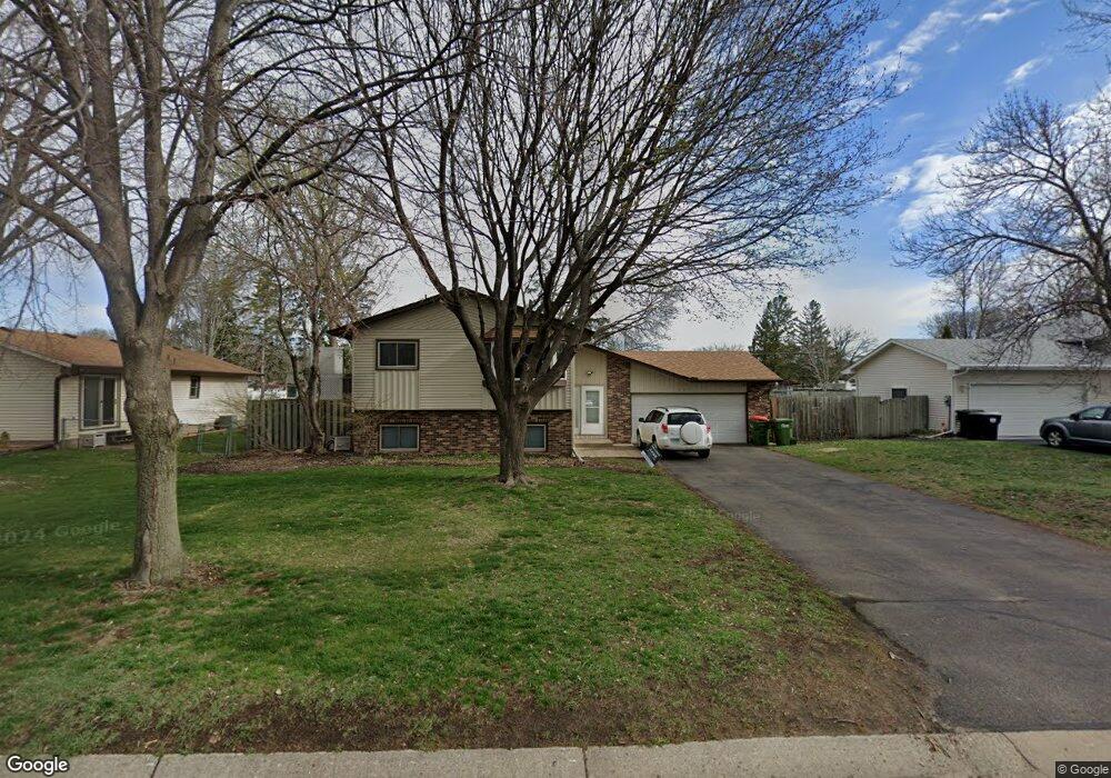
2271 112th Ln NW Coon Rapids, MN 55433
Estimated Value: $328,000 - $366,082
4
Beds
2
Baths
1,936
Sq Ft
$182/Sq Ft
Est. Value
About This Home
This home is located at 2271 112th Ln NW, Coon Rapids, MN 55433 and is currently estimated at $352,521, approximately $182 per square foot. 2271 112th Ln NW is a home located in Anoka County with nearby schools including Lucile Bruner Elementary School, Hamilton Elementary School, and Laughlin Junior/Senior High School.
Ownership History
Date
Name
Owned For
Owner Type
Purchase Details
Closed on
Aug 15, 2022
Sold by
Benson Linda
Bought by
Yang Chi and Vue Boon
Current Estimated Value
Home Financials for this Owner
Home Financials are based on the most recent Mortgage that was taken out on this home.
Original Mortgage
$328,932
Outstanding Balance
$314,944
Interest Rate
5.7%
Mortgage Type
New Conventional
Estimated Equity
$37,577
Create a Home Valuation Report for This Property
The Home Valuation Report is an in-depth analysis detailing your home's value as well as a comparison with similar homes in the area
Home Values in the Area
Average Home Value in this Area
Purchase History
| Date | Buyer | Sale Price | Title Company |
|---|---|---|---|
| Yang Chi | $340,000 | -- |
Source: Public Records
Mortgage History
| Date | Status | Borrower | Loan Amount |
|---|---|---|---|
| Open | Yang Chi | $328,932 |
Source: Public Records
Tax History Compared to Growth
Tax History
| Year | Tax Paid | Tax Assessment Tax Assessment Total Assessment is a certain percentage of the fair market value that is determined by local assessors to be the total taxable value of land and additions on the property. | Land | Improvement |
|---|---|---|---|---|
| 2025 | $3,310 | $334,600 | $84,000 | $250,600 |
| 2024 | $3,310 | $319,100 | $87,000 | $232,100 |
| 2023 | $3,064 | $315,300 | $76,000 | $239,300 |
| 2022 | $3,136 | $315,200 | $67,000 | $248,200 |
| 2021 | $2,986 | $270,700 | $67,000 | $203,700 |
| 2020 | $3,050 | $252,400 | $62,000 | $190,400 |
| 2019 | $2,894 | $247,600 | $60,000 | $187,600 |
| 2018 | $2,791 | $228,800 | $0 | $0 |
| 2017 | $2,458 | $214,600 | $0 | $0 |
| 2016 | $2,266 | $179,100 | $0 | $0 |
| 2015 | -- | $179,100 | $45,000 | $134,100 |
| 2014 | -- | $150,100 | $36,500 | $113,600 |
Source: Public Records
Map
Nearby Homes
- 11409 Quinn St NW
- 11424 Hanson Blvd NW
- 11444 Hanson Blvd NW
- 11000 Swallow St NW
- 11036 Hanson Blvd NW Unit 20
- 11350 Jay St NW
- 11361 Jay St NW
- 2400 108th Ave NW
- 11809 Zion St NW
- 2851 113th Ave NW
- 2201 108th Ave NW
- 11835 Crocus St NW
- 2721 109th Ave NW
- 2728 109th Ln NW
- 11749 Crooked Lake Blvd NW
- 2862 116th Ave NW
- 1660 Northdale Blvd NW
- 10648 Wren St NW
- 12019 Zion St NW
- 11267 Robinson Dr NW
- 2261 112th Ln NW
- 2301 112th Ln NW
- 2251 112th Ln NW
- 11271 Uplander St NW
- 2256 113th Ave NW
- 2270 112th Ln NW
- 2248 113th Ave NW
- 2264 113th Ave NW
- 2260 112th Ln NW
- 2300 112th Ln NW
- 2250 112th Ln NW
- 2272 113th Ave NW
- 2240 113th Ave NW
- 2310 112th Ln NW
- 2241 112th Ln NW
- 2232 113th Ave NW
- 2240 112th Ln NW
- 2231 112th Ln NW
- 2331 112th Ln NW
- 2255 113th Ave NW