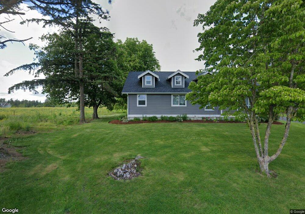
2272 Lindsay Rd Everson, WA 98247
Estimated Value: $762,000 - $890,600
3
Beds
1
Bath
1,360
Sq Ft
$608/Sq Ft
Est. Value
About This Home
This home is located at 2272 Lindsay Rd, Everson, WA 98247 and is currently estimated at $826,300, approximately $607 per square foot. 2272 Lindsay Rd is a home located in Whatcom County with nearby schools including Nooksack Elementary School, Everson Elementary School, and Sumas Elementary School.
Ownership History
Date
Name
Owned For
Owner Type
Purchase Details
Closed on
Feb 11, 2013
Sold by
Bos Justin
Bought by
Visser Brant and Visser Megan L
Current Estimated Value
Purchase Details
Closed on
Jan 24, 2011
Sold by
Cieslar Keith
Bought by
Bos Justin
Home Financials for this Owner
Home Financials are based on the most recent Mortgage that was taken out on this home.
Original Mortgage
$240,000
Interest Rate
4.79%
Mortgage Type
New Conventional
Create a Home Valuation Report for This Property
The Home Valuation Report is an in-depth analysis detailing your home's value as well as a comparison with similar homes in the area
Purchase History
| Date | Buyer | Sale Price | Title Company |
|---|---|---|---|
| Visser Brant | $346,280 | Chicago Title Insurance | |
| Bos Justin | $300,280 | Whatcom Land Title |
Source: Public Records
Mortgage History
| Date | Status | Borrower | Loan Amount |
|---|---|---|---|
| Previous Owner | Bos Justin | $240,000 |
Source: Public Records
Tax History
| Year | Tax Paid | Tax Assessment Tax Assessment Total Assessment is a certain percentage of the fair market value that is determined by local assessors to be the total taxable value of land and additions on the property. | Land | Improvement |
|---|---|---|---|---|
| 2025 | $5,596 | $835,459 | $462,644 | $372,815 |
| 2024 | $4,517 | $821,785 | $458,063 | $363,722 |
| 2023 | $4,517 | $950,604 | $515,430 | $435,174 |
| 2022 | $3,967 | $856,415 | $464,360 | $392,055 |
| 2021 | $3,844 | $669,060 | $362,773 | $306,287 |
| 2020 | $3,370 | $288,565 | $29,000 | $259,565 |
| 2019 | $2,980 | $511,815 | $277,513 | $234,302 |
| 2018 | $3,010 | $248,763 | $25,000 | $223,763 |
| 2017 | $2,634 | $183,466 | $20,979 | $162,487 |
| 2016 | $2,623 | $163,458 | $18,691 | $144,767 |
| 2014 | -- | $171,493 | $35,042 | $136,451 |
| 2013 | -- | $112,730 | $33,427 | $79,303 |
Source: Public Records
Map
Nearby Homes
- 1915 Hampton Rd
- 1925 Hampton Rd
- 1766 Hampton Rd
- 2173 Lagerwey Cir
- 2105 Lagerwey Cir
- 2103 Lagerwey Cir
- 2178 Lagerwey Cir
- 702 N Washington St
- 2014 Monteview Ct
- 408 W 3rd St
- 416 W 3rd St
- 2068 Bowfin Way
- 409 W 4th St
- 2027 Steelhead Way
- 303 Hayes St
- 1949 Junegrass Dr
- 1340 Kamm Rd
- 108 Baker St Unit 1-4
- 1979 Woodsman Dr
- 1963 Bluestem St
- 0 Lindsay Rd
- 0 Lindsay Rd
- 0 Lindsay Rd Unit NWM1278429
- 2314 Lindsay Rd
- 8544 Oxford Hill Ln
- 2305 Lindsay Rd
- 2192 Lindsay Rd
- 8616 Oxford Hill Ln
- 8603 Oxford Hill Ln
- 2406 Lindsay Rd
- 2401 Lindsay Rd
- 8607 Oxford Hill Ln
- 2178 Hampton Rd
- 8611 Oxford Hill Ln
- 2298 Hampton Rd
- 2106 Lindsay Rd
- 2054 Lindsay Rd
- 8617 Oxford Hill Ln
- 8607 Trapline Rd
- 2216 Hampton Rd
Your Personal Tour Guide
Ask me questions while you tour the home.