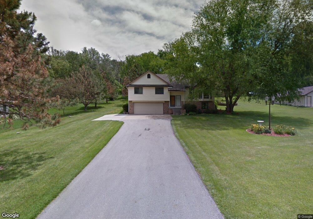
22725 Linden Rd W Crescent, IA 51526
Estimated Value: $412,000 - $486,000
3
Beds
2
Baths
1,700
Sq Ft
$263/Sq Ft
Est. Value
About This Home
This home is located at 22725 Linden Rd W, Crescent, IA 51526 and is currently estimated at $447,371, approximately $263 per square foot. 22725 Linden Rd W is a home located in Pottawattamie County with nearby schools including Crescent Elementary School, Gerald W. Kirn Middle School, and Abraham Lincoln High School.
Ownership History
Date
Name
Owned For
Owner Type
Purchase Details
Closed on
Aug 29, 2018
Sold by
Sieburg Douglas E and Sieburg Valerie A
Bought by
Siebrug Douglas E and Sieburg Valierie
Current Estimated Value
Purchase Details
Closed on
Jun 10, 2014
Sold by
Meis Kenneth C and Meis Suzanne
Bought by
Sieburg Doug and Sieburg Valerie A
Home Financials for this Owner
Home Financials are based on the most recent Mortgage that was taken out on this home.
Original Mortgage
$212,000
Outstanding Balance
$161,130
Interest Rate
4.18%
Mortgage Type
New Conventional
Estimated Equity
$286,241
Create a Home Valuation Report for This Property
The Home Valuation Report is an in-depth analysis detailing your home's value as well as a comparison with similar homes in the area
Home Values in the Area
Average Home Value in this Area
Purchase History
| Date | Buyer | Sale Price | Title Company |
|---|---|---|---|
| Siebrug Douglas E | -- | None Available | |
| Sieburg Doug | $265,000 | Clear Title & Abstract Llc |
Source: Public Records
Mortgage History
| Date | Status | Borrower | Loan Amount |
|---|---|---|---|
| Open | Sieburg Doug | $212,000 |
Source: Public Records
Tax History Compared to Growth
Tax History
| Year | Tax Paid | Tax Assessment Tax Assessment Total Assessment is a certain percentage of the fair market value that is determined by local assessors to be the total taxable value of land and additions on the property. | Land | Improvement |
|---|---|---|---|---|
| 2025 | $4,536 | $403,200 | $71,200 | $332,000 |
| 2024 | $4,536 | $341,600 | $62,000 | $279,600 |
| 2023 | $4,488 | $341,600 | $62,000 | $279,600 |
| 2022 | $4,424 | $284,100 | $57,900 | $226,200 |
| 2021 | $6,810 | $284,100 | $57,900 | $226,200 |
| 2020 | $4,168 | $284,100 | $57,900 | $226,200 |
| 2019 | $4,322 | $252,386 | $58,331 | $194,055 |
| 2018 | $4,246 | $252,386 | $58,331 | $194,055 |
| 2017 | $4,316 | $252,386 | $58,331 | $194,055 |
| 2015 | $4,236 | $252,386 | $58,331 | $194,055 |
| 2014 | $4,242 | $252,386 | $58,331 | $194,055 |
Source: Public Records
Map
Nearby Homes
- 500 Powells Add
- 106 Sharon Dr
- 1339 Copper Mountain Dr
- 1335 Copper Mountain Dr
- 1511 Platinum Dr
- 1318 Silver Ln
- 1314 Silver Ln
- 1321 Copper Mountain Dr
- 1317 Silver Ln
- 1315 Silver Ln
- 104 E Florence St
- 20 ACRES Old Lincoln Hwy
- 32 ACRES Old Lincoln Hwy
- 114 Riordan St
- 61.50ACRES Honeysuckle Rd
- 71.95ACRES Honeysuckle Rd
- 143.23 AC 195th St
- 22395 205th St
- 18843 Evergreen Ln
- 19404 Mudhollow Rd
- 22737 Linden Rd W
- 22769 Linden Rd W
- LOT 31 Linden Rd W
- 22746 Linden Rd E
- 22793 Linden Rd W
- 22780 Linden Rd W
- 22807 Linden Rd W
- 22782 Linden Rd W
- 22742 Linden Rd W
- 22794 Linden Rd E
- 22728 Linden Rd E
- 22713 Linden Rd W
- 22839 Linden Rd W
- 22804 Linden Rd W
- 22722 Linden Rd W
- 22796 Old Lincoln Hwy
- 22843 Linden Rd W
- 17191 Oak Valley Rd
- 22875 Linden Rd W
- 22840 Linden Rd W