Estimated Value: $427,000 - $443,798
4
Beds
3
Baths
2,372
Sq Ft
$183/Sq Ft
Est. Value
About This Home
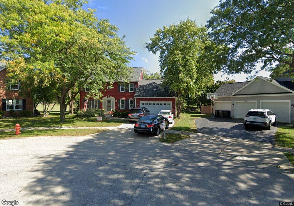
This home is located at 2275 Cedar Point Ct, Elgin, IL 60123 and is currently estimated at $434,950, approximately $183 per square foot. 2275 Cedar Point Ct is a home located in Kane County with nearby schools including Fox Meadow Elementary School, Kenyon Woods Middle School, and South Elgin High School.
Ownership History
Date
Name
Owned For
Owner Type
Purchase Details
Closed on
Jun 26, 2002
Sold by
Ricker Robert S and Ricker Delores J
Bought by
Powers Richard A and Powers Laurie A
Current Estimated Value
Home Financials for this Owner
Home Financials are based on the most recent Mortgage that was taken out on this home.
Original Mortgage
$196,000
Outstanding Balance
$83,618
Interest Rate
6.8%
Estimated Equity
$351,332
Create a Home Valuation Report for This Property
The Home Valuation Report is an in-depth analysis detailing your home's value as well as a comparison with similar homes in the area
Home Values in the Area
Average Home Value in this Area
Purchase History
| Date | Buyer | Sale Price | Title Company |
|---|---|---|---|
| Powers Richard A | $245,000 | Ticor Title Insurance Compan |
Source: Public Records
Mortgage History
| Date | Status | Borrower | Loan Amount |
|---|---|---|---|
| Open | Powers Richard A | $196,000 | |
| Closed | Powers Richard A | $36,000 |
Source: Public Records
Tax History
| Year | Tax Paid | Tax Assessment Tax Assessment Total Assessment is a certain percentage of the fair market value that is determined by local assessors to be the total taxable value of land and additions on the property. | Land | Improvement |
|---|---|---|---|---|
| 2024 | $10,190 | $135,334 | $32,132 | $103,202 |
| 2023 | $9,740 | $122,264 | $29,029 | $93,235 |
| 2022 | $9,147 | $111,483 | $26,469 | $85,014 |
| 2021 | $8,764 | $104,229 | $24,747 | $79,482 |
| 2020 | $8,528 | $99,503 | $23,625 | $75,878 |
| 2019 | $8,292 | $94,783 | $22,504 | $72,279 |
| 2018 | $8,235 | $89,291 | $21,200 | $68,091 |
| 2017 | $8,065 | $84,412 | $20,042 | $64,370 |
| 2016 | $7,712 | $78,312 | $18,594 | $59,718 |
| 2015 | -- | $71,780 | $17,043 | $54,737 |
| 2014 | -- | $62,360 | $14,833 | $47,527 |
| 2013 | -- | $64,005 | $15,224 | $48,781 |
Source: Public Records
Map
Nearby Homes
- 1512 Birch Ln
- 2350 Camden Bay Unit 176A
- 1202 Delta Dr Unit 115B
- 1141 Delta Ct Unit 255E
- 1094 Delta Dr Unit 41A
- 404 Lowell Dr Unit 3
- 522 Lowell Dr Unit 2
- 27 Frederick Ct
- 120 Kingsport Dr
- 1247 Sandhurst Ln Unit 4
- 400 Comstock Rd
- Harrison Plan at Becketts Landing - The Townes at Becketts
- Talman Plan at Becketts Landing - The Townes at Becketts
- Stewart Plan at Becketts Landing - The Townes at Becketts
- Meade Plan at Becketts Landing - The Townes at Becketts
- 306 Kingsport Dr
- 326 Kingsport Dr
- 291 Kingsport Dr
- 402 Comstock Rd
- 320 Kingsport Dr
- 2270 Cedar Point Ct
- 2279 Cedar Point Ct
- 2276 Cottonwood Ct
- 2280 Cedar Point Ct
- 2285 Cedar Point Ct
- 2278 Cottonwood Ct
- 2274 Cottonwood Ct
- 2289 Cedar Point Ct
- 1303 Umbdenstock Rd
- 2279 Country Water Ct
- 2285 Country Water Ct
- 2284 Cottonwood Dr
- 1299 Umbdenstock Rd
- 2280 Cottonwood Dr
- 2299 Cedar Point Ct
- 2288 Cottonwood Dr
- 2272 Cottonwood Ct
- 1295 Umbdenstock Rd
- 1335 Umbdenstock Rd
- 2275 Country Water Ct
Your Personal Tour Guide
Ask me questions while you tour the home.