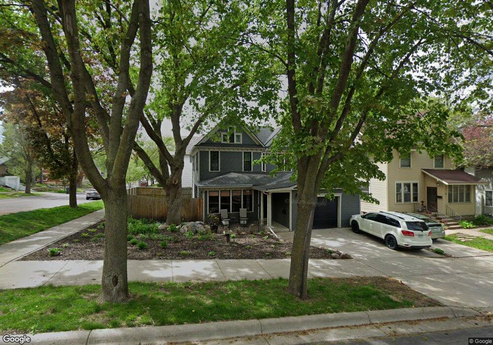
228 Locke St Mankato, MN 56001
Lincoln Park NeighborhoodEstimated Value: $234,000 - $258,000
3
Beds
3
Baths
1,800
Sq Ft
$137/Sq Ft
Est. Value
About This Home
This home is located at 228 Locke St, Mankato, MN 56001 and is currently estimated at $246,624, approximately $137 per square foot. 228 Locke St is a home located in Blue Earth County with nearby schools including Jefferson Elementary School, Dakota Meadows Middle School, and Mankato West Senior High School.
Ownership History
Date
Name
Owned For
Owner Type
Purchase Details
Closed on
Jul 15, 2009
Sold by
Hachfeld Dale E and Hachfeld Diane J
Bought by
Carlberg Chad and Carlberg Theresa
Current Estimated Value
Home Financials for this Owner
Home Financials are based on the most recent Mortgage that was taken out on this home.
Original Mortgage
$124,522
Outstanding Balance
$81,519
Interest Rate
5.37%
Mortgage Type
FHA
Estimated Equity
$165,105
Create a Home Valuation Report for This Property
The Home Valuation Report is an in-depth analysis detailing your home's value as well as a comparison with similar homes in the area
Home Values in the Area
Average Home Value in this Area
Purchase History
| Date | Buyer | Sale Price | Title Company |
|---|---|---|---|
| Carlberg Chad | $126,820 | -- |
Source: Public Records
Mortgage History
| Date | Status | Borrower | Loan Amount |
|---|---|---|---|
| Open | Carlberg Chad | $124,522 |
Source: Public Records
Tax History Compared to Growth
Tax History
| Year | Tax Paid | Tax Assessment Tax Assessment Total Assessment is a certain percentage of the fair market value that is determined by local assessors to be the total taxable value of land and additions on the property. | Land | Improvement |
|---|---|---|---|---|
| 2025 | $2,184 | $232,000 | $23,400 | $208,600 |
| 2024 | $2,184 | $215,100 | $23,400 | $191,700 |
| 2023 | $4,106 | $236,900 | $23,400 | $213,500 |
| 2022 | $3,802 | $213,000 | $23,400 | $189,600 |
| 2021 | $3,630 | $176,500 | $23,400 | $153,100 |
| 2020 | $3,344 | $141,900 | $23,400 | $118,500 |
| 2019 | $3,330 | $141,900 | $23,400 | $118,500 |
| 2018 | $3,244 | $140,500 | $23,400 | $117,100 |
| 2017 | $2,970 | $134,600 | $23,400 | $111,200 |
| 2016 | $3,058 | $119,400 | $23,400 | $96,000 |
| 2015 | $30 | $126,700 | $23,400 | $103,300 |
| 2014 | $1,232 | $122,000 | $23,400 | $98,600 |
Source: Public Records
Map
Nearby Homes
- 212 Locke St
- 231 Bradley St
- 26 Sumner Hills Rd
- 217 Center St
- 117 E Pleasant St
- 117 117 E Pleasant St
- 222 W Pleasant St
- 222 222 W Pleasant St
- 315 W Pleasant St
- 340 Rd
- 309 309 Locust St
- TBD Saratoga
- 130 Dillon Ave
- 316 316 Stoltzman Rd
- 316 Stoltzman Rd
- 314 314 E Walnut St
- 0 Outlot A Block 1 Unit 7031909
- 109 109 S 4th St
- 0 R010918476042 Tbd Woodridge Unit 7036731
- 601 Baker Ave
- 220 Locke St
- 230 Bradley St
- 226 Bradley St
- 216 Locke St
- 229 Locke St
- 229 Locke St Unit 4 bed room
- 224 Bradley St
- 233 Bradley St
- 225 Locke St
- 225 Locke St Unit 225 Locke Street
- 221 Locke St
- 220 Bradley St
- 214 Locke St
- 235 Bradley St
- 235 Bradley St Unit 235 Bradley Street
- 225 Bradley St
- 315 Bradley St
- 216 Bradley St
- 215 Locke St
- 211 Locke St