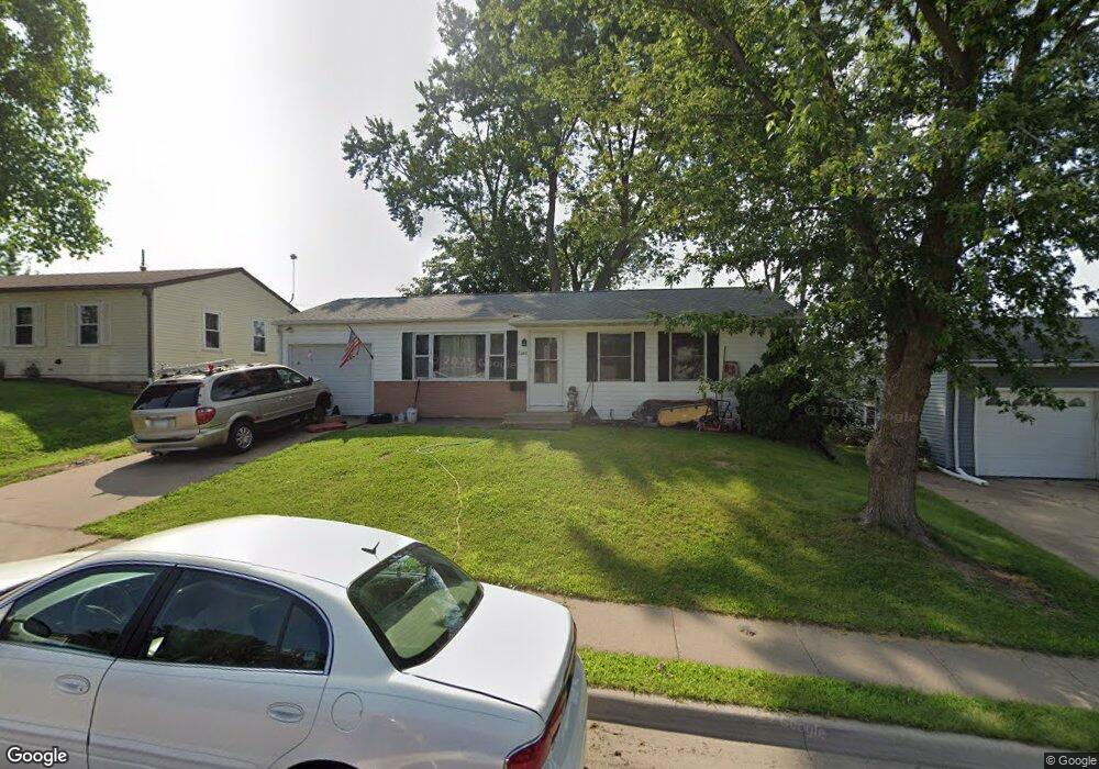
2285 Theda Dr Dubuque, IA 52001
Estimated Value: $196,000 - $216,000
3
Beds
2
Baths
1,255
Sq Ft
$164/Sq Ft
Est. Value
About This Home
This home is located at 2285 Theda Dr, Dubuque, IA 52001 and is currently estimated at $205,708, approximately $163 per square foot. 2285 Theda Dr is a home located in Dubuque County with nearby schools including Eisenhower Elementary School, Eleanor Roosevelt Middle School, and Dubuque Senior High School.
Ownership History
Date
Name
Owned For
Owner Type
Purchase Details
Closed on
Jul 3, 2015
Sold by
Luksetich Thomas A and Luksetich Rita J
Bought by
Herrig John H and Herrig Sally Jo
Current Estimated Value
Purchase Details
Closed on
Oct 24, 2008
Sold by
Owen Michael E and Owen Kay A
Bought by
Herrig John W and Herrig Sally Jo
Home Financials for this Owner
Home Financials are based on the most recent Mortgage that was taken out on this home.
Original Mortgage
$43,600
Interest Rate
5.99%
Mortgage Type
Purchase Money Mortgage
Purchase Details
Closed on
May 25, 2007
Sold by
Yeager Neill G and Yeager Judith K
Bought by
Owen Michael E and Owen Kav A
Home Financials for this Owner
Home Financials are based on the most recent Mortgage that was taken out on this home.
Original Mortgage
$101,000
Interest Rate
6.22%
Mortgage Type
New Conventional
Create a Home Valuation Report for This Property
The Home Valuation Report is an in-depth analysis detailing your home's value as well as a comparison with similar homes in the area
Home Values in the Area
Average Home Value in this Area
Purchase History
| Date | Buyer | Sale Price | Title Company |
|---|---|---|---|
| Herrig John H | $3,000 | None Available | |
| Herrig John W | $109,000 | None Available | |
| Owen Michael E | $103,000 | None Available |
Source: Public Records
Mortgage History
| Date | Status | Borrower | Loan Amount |
|---|---|---|---|
| Previous Owner | Herrig John W | $43,600 | |
| Previous Owner | Owen Michael E | $101,000 |
Source: Public Records
Tax History Compared to Growth
Tax History
| Year | Tax Paid | Tax Assessment Tax Assessment Total Assessment is a certain percentage of the fair market value that is determined by local assessors to be the total taxable value of land and additions on the property. | Land | Improvement |
|---|---|---|---|---|
| 2025 | $2,368 | $179,200 | $33,900 | $145,300 |
| 2024 | $2,368 | $164,700 | $32,200 | $132,500 |
| 2023 | $2,300 | $164,700 | $32,200 | $132,500 |
| 2022 | $2,238 | $135,330 | $29,020 | $106,310 |
| 2021 | $2,238 | $135,330 | $29,020 | $106,310 |
| 2020 | $2,116 | $118,970 | $27,400 | $91,570 |
| 2019 | $2,104 | $118,970 | $27,400 | $91,570 |
| 2018 | $2,072 | $113,130 | $25,790 | $87,340 |
| 2017 | $2,034 | $113,130 | $25,790 | $87,340 |
| 2016 | $1,992 | $105,320 | $25,790 | $79,530 |
| 2015 | $1,992 | $105,320 | $25,790 | $79,530 |
| 2014 | $1,910 | $103,760 | $25,790 | $77,970 |
Source: Public Records
Map
Nearby Homes
- 2290 Theda Dr
- 2380 Trygg Dr
- 3112 Kaufmann Ave
- 2560 Crissy Dr
- 2614 Crissy Dr
- 2146 Avalon Rd
- 3462 Asbury Rd
- 2347 Coventry Park Unit C-011
- 2035 Broadlawn Rd
- 2628 Dove St
- 2816 John F. Kennedy Rd
- 2820 John F. Kennedy Rd
- 2095 Mullin Rd
- 1930 Scenic View Dr
- 3080 Saint Anne Dr
- 3519 Hillcrest Rd
- 3575 Lisa Ct
- 2145 Saint John Dr
- 3725 Asbury Rd
- 1790 Horizon Ct