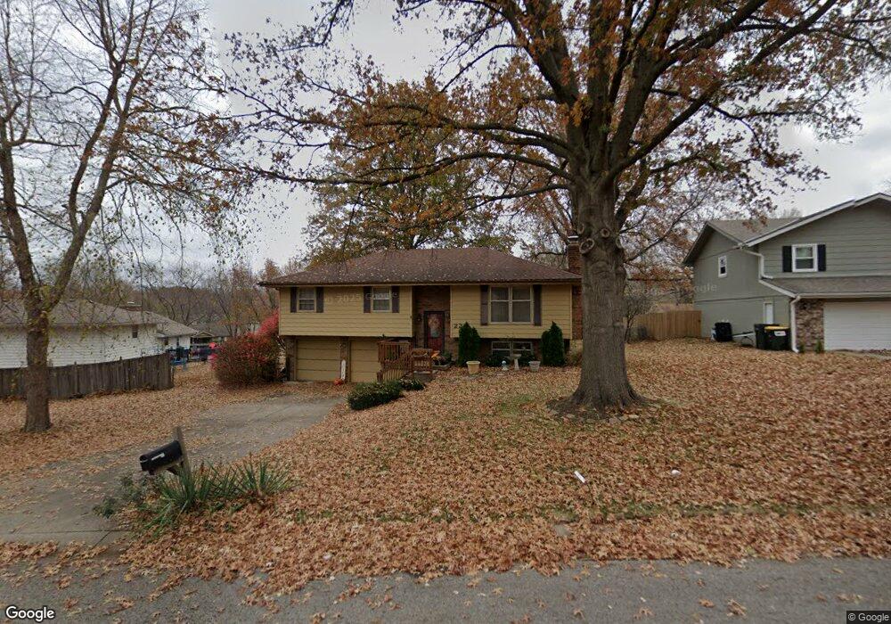
229 Bittersweet Ln Lansing, KS 66043
Estimated Value: $256,240 - $307,000
4
Beds
3
Baths
1,276
Sq Ft
$222/Sq Ft
Est. Value
About This Home
This home is located at 229 Bittersweet Ln, Lansing, KS 66043 and is currently estimated at $283,060, approximately $221 per square foot. 229 Bittersweet Ln is a home located in Leavenworth County with nearby schools including Lansing Elementary School, Lansing Middle 6-8, and Lansing High 9-12.
Ownership History
Date
Name
Owned For
Owner Type
Purchase Details
Closed on
Apr 18, 2023
Sold by
Deiter Patricia Rae
Bought by
Patricia R Deiter Living Trust
Current Estimated Value
Purchase Details
Closed on
Apr 1, 1999
Bought by
Deiter Paul David and Deiter Patricia Rae
Home Financials for this Owner
Home Financials are based on the most recent Mortgage that was taken out on this home.
Original Mortgage
$25,001
Interest Rate
6.98%
Mortgage Type
New Conventional
Create a Home Valuation Report for This Property
The Home Valuation Report is an in-depth analysis detailing your home's value as well as a comparison with similar homes in the area
Home Values in the Area
Average Home Value in this Area
Purchase History
| Date | Buyer | Sale Price | Title Company |
|---|---|---|---|
| Patricia R Deiter Living Trust | -- | None Listed On Document | |
| Deiter Paul David | $110,900 | -- |
Source: Public Records
Mortgage History
| Date | Status | Borrower | Loan Amount |
|---|---|---|---|
| Previous Owner | Deiter Paul David | $25,001 |
Source: Public Records
Tax History Compared to Growth
Tax History
| Year | Tax Paid | Tax Assessment Tax Assessment Total Assessment is a certain percentage of the fair market value that is determined by local assessors to be the total taxable value of land and additions on the property. | Land | Improvement |
|---|---|---|---|---|
| 2025 | $3,463 | $27,174 | $4,997 | $22,177 |
| 2024 | $3,233 | $26,128 | $3,962 | $22,166 |
| 2023 | $3,233 | $25,123 | $3,962 | $21,161 |
| 2022 | $3,109 | $22,839 | $3,073 | $19,766 |
| 2021 | $2,962 | $20,670 | $3,073 | $17,597 |
| 2020 | $2,718 | $18,688 | $3,073 | $15,615 |
| 2019 | $2,497 | $17,171 | $3,073 | $14,098 |
| 2018 | $2,496 | $17,171 | $2,552 | $14,619 |
| 2017 | $2,295 | $15,776 | $2,552 | $13,224 |
| 2016 | $2,272 | $15,619 | $2,552 | $13,067 |
| 2015 | $2,266 | $15,619 | $2,552 | $13,067 |
| 2014 | $2,219 | $15,619 | $2,552 | $13,067 |
Source: Public Records
Map
Nearby Homes
- 218 Oak Hill St
- 20958 Ida St
- 415 Fairlane St
- 129 Crestview Ct
- 129 Brookwood St
- 268 Holiday Dr
- 542 Creekside Ct
- 124 S Main St
- 202 S Main St
- 527 S Valley Dr
- 218 E Kay St
- 1102 N Main St
- 310 E Kansas Ave
- 104 Olive St
- 4 Eisenhower Rd
- 306 E Kay St
- 1100 N 4th St
- 1102 N 4th St
- 728 Eisenhower Rd
- 603 E Beth St
- 221 Bittersweet Ln
- 237 Bittersweet Ln
- 226 Oak Hill St
- 213 Bittersweet Ln
- 224 Bittersweet Ln
- 232 Bittersweet Ln
- 304 Bittersweet Ln
- 210 Oak Hill St
- 205 Bittersweet Ln
- 312 Bittersweet Ln
- 208 Bittersweet Ln
- 325 Oakhill St
- 317 Oak Hill St
- 204 Oak Hill St
- 121 Brookridge St
- 325 Oak Hill St
- 301 Oak Hill St
- 119 Brookridge St
- 123 Brookridge St
- 233 Oak Hill St