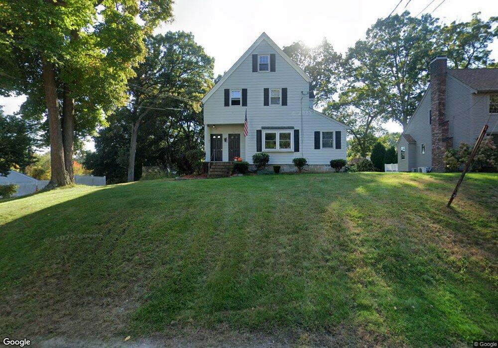
229 Dedham Ave Needham, MA 02492
Estimated Value: $1,105,000 - $1,256,982
3
Beds
2
Baths
1,018
Sq Ft
$1,188/Sq Ft
Est. Value
About This Home
This home is located at 229 Dedham Ave, Needham, MA 02492 and is currently estimated at $1,209,246, approximately $1,187 per square foot. 229 Dedham Ave is a home located in Norfolk County with nearby schools including Newman Elementary School, High Rock Middle School, and Pollard Middle School.
Ownership History
Date
Name
Owned For
Owner Type
Purchase Details
Closed on
Jun 12, 2017
Sold by
Macdonald Kevin K and Macdonald Mora S
Bought by
Macdonald Mora S and Macdonald Kevin K
Current Estimated Value
Create a Home Valuation Report for This Property
The Home Valuation Report is an in-depth analysis detailing your home's value as well as a comparison with similar homes in the area
Home Values in the Area
Average Home Value in this Area
Purchase History
| Date | Buyer | Sale Price | Title Company |
|---|---|---|---|
| Macdonald Mora S | -- | -- | |
| Macdonald Mora S | -- | -- |
Source: Public Records
Mortgage History
| Date | Status | Borrower | Loan Amount |
|---|---|---|---|
| Previous Owner | Macdonald Mora S | $30,000 | |
| Previous Owner | Macdonald Mora S | $60,000 |
Source: Public Records
Tax History
| Year | Tax Paid | Tax Assessment Tax Assessment Total Assessment is a certain percentage of the fair market value that is determined by local assessors to be the total taxable value of land and additions on the property. | Land | Improvement |
|---|---|---|---|---|
| 2025 | $9,986 | $942,100 | $736,500 | $205,600 |
| 2024 | $8,218 | $656,400 | $506,800 | $149,600 |
| 2023 | $8,411 | $645,000 | $506,800 | $138,200 |
| 2022 | $8,058 | $602,700 | $470,300 | $132,400 |
| 2021 | $7,853 | $602,700 | $470,300 | $132,400 |
| 2020 | $7,603 | $608,700 | $470,300 | $138,400 |
| 2019 | $6,979 | $563,300 | $428,700 | $134,600 |
| 2018 | $6,692 | $563,300 | $428,700 | $134,600 |
| 2017 | $6,485 | $545,400 | $428,700 | $116,700 |
| 2016 | $6,294 | $545,400 | $428,700 | $116,700 |
| 2015 | $6,158 | $545,400 | $428,700 | $116,700 |
| 2014 | $5,655 | $485,800 | $374,500 | $111,300 |
Source: Public Records
Map
Nearby Homes
- 971 Webster St
- 100 Bradford St
- 68 Pleasant St Unit 68
- 1011 Webster St
- 60 Sutton Rd
- 233 Warren St
- 90 Norfolk St
- 150 Laurel Dr
- 36 Otis St Unit 36
- 126 Prince St
- 73 Maple St Unit 1
- 193 Garden St
- 47 Emerson Rd
- 569 Chestnut St
- 31 Birds Hill Ave
- 19 Highland Ct Unit 19
- 19 Oakland Ave Unit 19
- 638 Webster St
- 638 Webster St Unit 638
- 287 High Rock St
- 225 Dedham Ave
- 239 Dedham Ave
- 219 Dedham Ave
- 944 Webster St
- 245 Dedham Ave
- 236 Dedham Ave
- 140 Bradford St
- 938 Webster St
- 952 Webster St
- 220 Dedham Ave
- 242 Dedham Ave
- 954 Webster St
- 213 Dedham Ave
- 968 Webster St
- 962 Webster St
- 251 Dedham Ave
- 248 Dedham Ave
- 133 Bradford St
- 978 Webster St
- 137 Bradford St
Your Personal Tour Guide
Ask me questions while you tour the home.