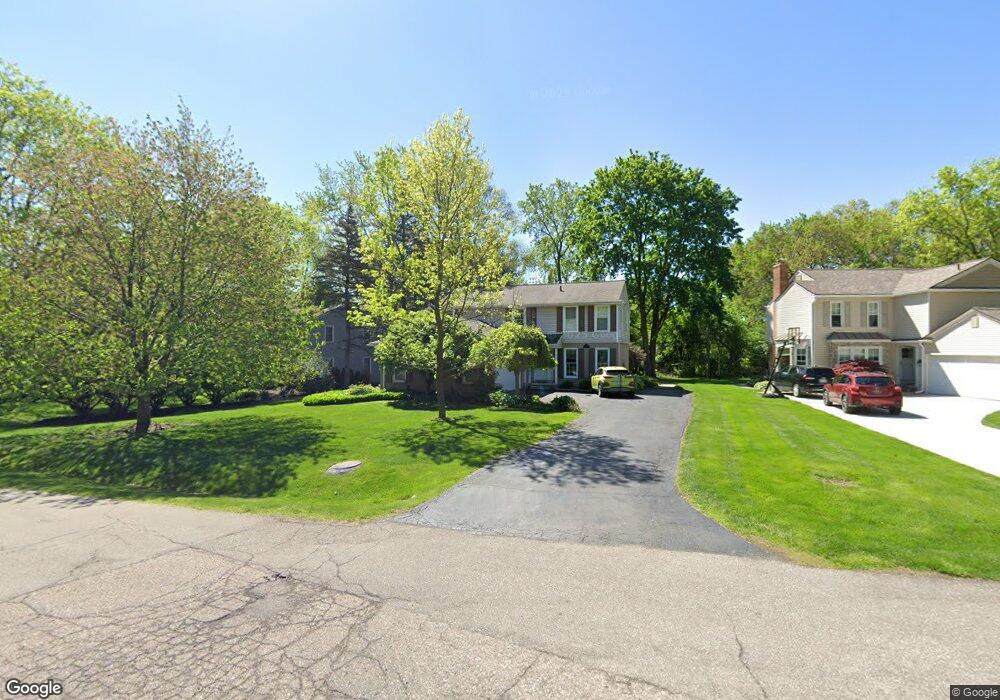
229 Eileen Dr Bloomfield Hills, MI 48302
Estimated Value: $430,333 - $528,000
4
Beds
3
Baths
2,096
Sq Ft
$222/Sq Ft
Est. Value
About This Home
This home is located at 229 Eileen Dr, Bloomfield Hills, MI 48302 and is currently estimated at $465,333, approximately $222 per square foot. 229 Eileen Dr is a home located in Oakland County with nearby schools including Way Elementary School, South Hills Middle School, and Bloomfield Hills High School.
Ownership History
Date
Name
Owned For
Owner Type
Purchase Details
Closed on
Jun 5, 2017
Sold by
Sander Edward M and Sander Regina A
Bought by
Sander Edward M and Sander Regina A
Current Estimated Value
Purchase Details
Closed on
Aug 3, 1999
Sold by
Welch William
Bought by
Sander Edward M
Create a Home Valuation Report for This Property
The Home Valuation Report is an in-depth analysis detailing your home's value as well as a comparison with similar homes in the area
Home Values in the Area
Average Home Value in this Area
Purchase History
| Date | Buyer | Sale Price | Title Company |
|---|---|---|---|
| Sander Edward M | -- | None Available | |
| Sander Edward M | $150,000 | -- | |
| Sander Edward M | $150,000 | -- |
Source: Public Records
Tax History
| Year | Tax Paid | Tax Assessment Tax Assessment Total Assessment is a certain percentage of the fair market value that is determined by local assessors to be the total taxable value of land and additions on the property. | Land | Improvement |
|---|---|---|---|---|
| 2025 | $4,542 | $203,610 | $29,800 | $173,810 |
| 2024 | $2,279 | $203,610 | $0 | $0 |
| 2023 | $2,205 | $191,920 | $0 | $0 |
| 2022 | $4,147 | $160,070 | $0 | $0 |
| 2021 | $4,126 | $142,730 | $0 | $0 |
| 2020 | $2,017 | $140,610 | $0 | $0 |
| 2019 | $3,887 | $142,980 | $0 | $0 |
| 2018 | $3,894 | $141,800 | $0 | $0 |
| 2017 | $3,866 | $139,510 | $0 | $0 |
| 2016 | $3,870 | $124,170 | $0 | $0 |
| 2015 | -- | $111,880 | $0 | $0 |
| 2014 | -- | $102,640 | $0 | $0 |
| 2011 | -- | $90,080 | $0 | $0 |
Source: Public Records
Map
Nearby Homes
- 2381 Bratton Ave
- 00 S Berkshire
- 2570 Aspen Ln
- 2835 Aspen Ln
- 0000 Devon Rd
- 2863 Meadowood Ln
- 2871 Meadowood Ln
- 164 Timber Trace Ln
- 1661 Winthrop Rd
- 350 Fremont St
- 95 Hillsdale Rd
- 62 Barrington Rd
- 256 E Highland Ave
- 237 Marlborough Dr
- 200 Cedardale Ave
- 2864 Colonial Trail
- 3080 Chickering Ct
- 2851 Franklin Rd
- 256 Cedardale Ave
- 1085 Frankel Ln
- 239 Eileen Dr
- 225 Eileen Dr
- 2415 Emerson Ave
- 219 Eileen Dr
- 2490 Parcells Cir
- 211 Eileen Dr
- 2425 Emerson Ave
- 220 Eileen Dr
- 2478 Parcells Cir
- 226 Eileen Dr
- 234 Eileen Dr
- 2504 Parcells Cir
- 2398 Parcells Cir
- 216 Eileen Dr
- 2434 Parcells Cir
- 244 Eileen Dr
- 2447 Emerson Ave
- 200 Eileen Dr
- 2410 Emerson Ave
- 254 Eileen Dr
Your Personal Tour Guide
Ask me questions while you tour the home.