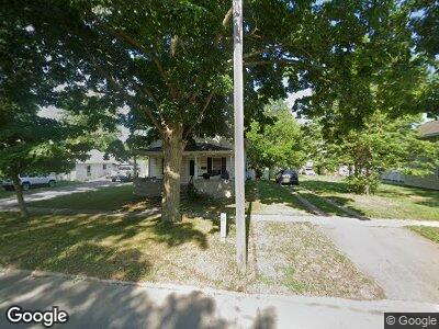
229 Oak St Morenci, MI 49256
Morenci NeighborhoodEstimated Value: $70,000 - $123,000
2
Beds
1
Bath
1,615
Sq Ft
$63/Sq Ft
Est. Value
About This Home
This home is located at 229 Oak St, Morenci, MI 49256 and is currently estimated at $102,261, approximately $63 per square foot. 229 Oak St is a home located in Lenawee County with nearby schools including Morenci Elementary School and Morenci Middle/High School.
Ownership History
Date
Name
Owned For
Owner Type
Purchase Details
Closed on
Jun 5, 2013
Sold by
Vanvanhavel John Van
Bought by
Williams Daniel Ray
Current Estimated Value
Home Financials for this Owner
Home Financials are based on the most recent Mortgage that was taken out on this home.
Original Mortgage
$44,000
Outstanding Balance
$33,433
Interest Rate
4.25%
Mortgage Type
Seller Take Back
Estimated Equity
$104,711
Purchase Details
Closed on
Sep 17, 2007
Sold by
Novastar Mortgage Inc
Bought by
Baumgartner David P and Baumgartner Penny J
Home Financials for this Owner
Home Financials are based on the most recent Mortgage that was taken out on this home.
Original Mortgage
$26,910
Interest Rate
7.5%
Mortgage Type
Adjustable Rate Mortgage/ARM
Purchase Details
Closed on
Jul 12, 2007
Sold by
Blaker Joshua M R and Blaker Tracey Lynne
Bought by
Novastar Mortgage Inc
Create a Home Valuation Report for This Property
The Home Valuation Report is an in-depth analysis detailing your home's value as well as a comparison with similar homes in the area
Home Values in the Area
Average Home Value in this Area
Purchase History
| Date | Buyer | Sale Price | Title Company |
|---|---|---|---|
| Williams Daniel Ray | $45,000 | None Available | |
| Baumgartner David P | $29,900 | Fidelity Land Title Agency | |
| Novastar Mortgage Inc | $46,106 | None Available |
Source: Public Records
Mortgage History
| Date | Status | Borrower | Loan Amount |
|---|---|---|---|
| Open | Williams Daniel Ray | $44,000 | |
| Closed | Baumgartner David P | $26,910 |
Source: Public Records
Tax History Compared to Growth
Tax History
| Year | Tax Paid | Tax Assessment Tax Assessment Total Assessment is a certain percentage of the fair market value that is determined by local assessors to be the total taxable value of land and additions on the property. | Land | Improvement |
|---|---|---|---|---|
| 2024 | $1,384 | $33,800 | $0 | $0 |
| 2022 | $1,625 | $28,900 | $0 | $0 |
| 2021 | $810 | $27,400 | $0 | $0 |
| 2020 | $810 | $24,800 | $0 | $0 |
| 2019 | $53,910 | $22,900 | $0 | $0 |
| 2018 | $53,910 | $19,051 | $0 | $0 |
| 2017 | $534 | $18,919 | $0 | $0 |
| 2016 | $0 | $18,499 | $0 | $0 |
| 2014 | -- | $17,574 | $0 | $0 |
Source: Public Records
Map
Nearby Homes
- 428 Buffalo St
- 414 Centre St
- 324 Owosso St
- 538 Whitney Ave
- 328 E Main St
- 210 W Locust St
- Block Skyline Dr
- 118 E Chestnut St
- 400 Gorham Blk St
- 416 Clark St
- 413 Lincoln St
- 11854 Morenci Rd
- 11035 Elliott Hwy
- 8058 Packard Rd
- 8586 Tuttle Hwy
- 10300 Canandaigua Rd
- 16248 Wabash Rd
- 201 E Spring St
- 10778 Sand Creek Hwy
- 7410 Warwick Rd
