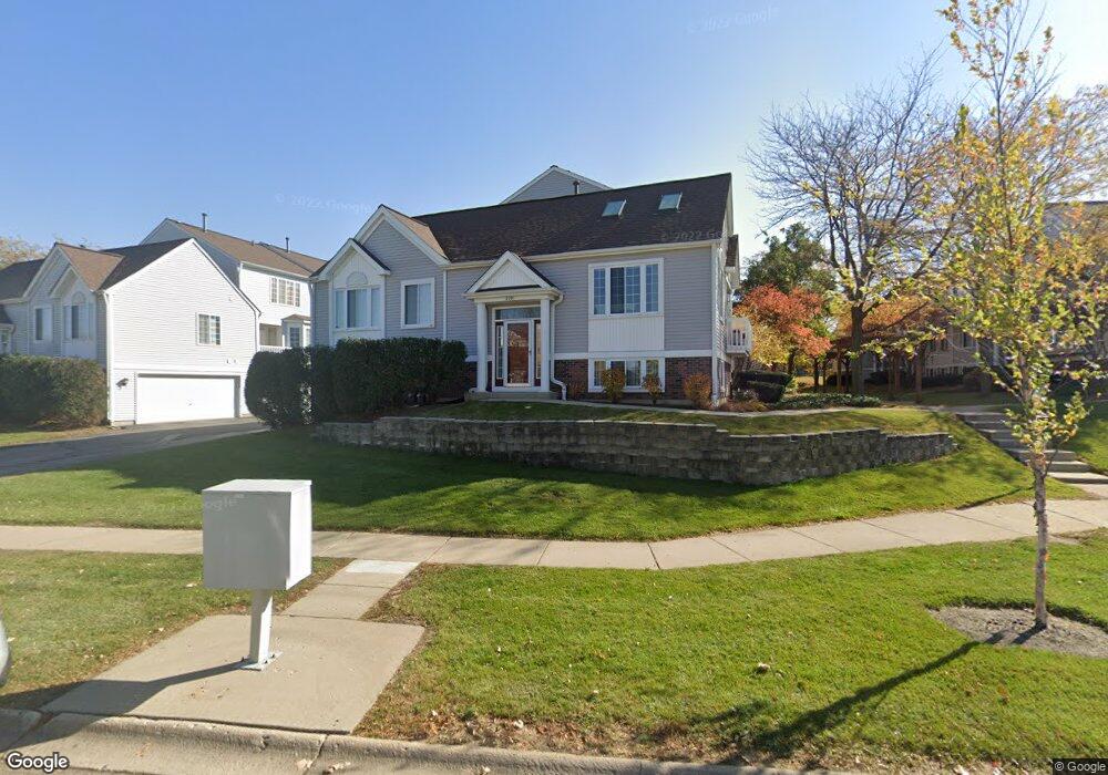
2293 Dawson Ln Algonquin, IL 60102
Estimated Value: $225,738 - $285,000
2
Beds
3
Baths
1,401
Sq Ft
$187/Sq Ft
Est. Value
About This Home
This home is located at 2293 Dawson Ln, Algonquin, IL 60102 and is currently estimated at $262,185, approximately $187 per square foot. 2293 Dawson Ln is a home located in McHenry County with nearby schools including Westfield Community School, Lincoln Prairie Elementary School, and Harry D Jacobs High School.
Ownership History
Date
Name
Owned For
Owner Type
Purchase Details
Closed on
Oct 29, 2008
Sold by
Stott Ernestina
Bought by
Stott Douglas E
Current Estimated Value
Purchase Details
Closed on
Mar 29, 1996
Sold by
Pulte Home Corp
Bought by
Stott Douglas E
Home Financials for this Owner
Home Financials are based on the most recent Mortgage that was taken out on this home.
Original Mortgage
$122,200
Interest Rate
6.98%
Create a Home Valuation Report for This Property
The Home Valuation Report is an in-depth analysis detailing your home's value as well as a comparison with similar homes in the area
Purchase History
| Date | Buyer | Sale Price | Title Company |
|---|---|---|---|
| Stott Douglas E | -- | None Available | |
| Stott Douglas E | $131,500 | First American Title |
Source: Public Records
Mortgage History
| Date | Status | Borrower | Loan Amount |
|---|---|---|---|
| Previous Owner | Stott Douglas E | $122,200 |
Source: Public Records
Tax History Compared to Growth
Tax History
| Year | Tax Paid | Tax Assessment Tax Assessment Total Assessment is a certain percentage of the fair market value that is determined by local assessors to be the total taxable value of land and additions on the property. | Land | Improvement |
|---|---|---|---|---|
| 2024 | $4,610 | $66,929 | $14,040 | $52,889 |
| 2023 | $4,341 | $59,860 | $12,557 | $47,303 |
| 2022 | $4,676 | $60,528 | $11,160 | $49,368 |
| 2021 | $4,471 | $56,389 | $10,397 | $45,992 |
| 2020 | $4,345 | $54,393 | $10,029 | $44,364 |
| 2019 | $4,230 | $52,061 | $9,599 | $42,462 |
| 2018 | $4,012 | $48,093 | $8,867 | $39,226 |
| 2017 | $3,914 | $45,306 | $8,353 | $36,953 |
| 2016 | $3,838 | $42,493 | $7,834 | $34,659 |
| 2013 | -- | $42,128 | $7,308 | $34,820 |
Source: Public Records
Map
Nearby Homes
- 2233 Dawson Ln Unit 312
- 2380 Dawson Ln Unit 165
- 681 Majestic Dr
- 741 Regal Ln
- 1920 Jester Ln
- 1820 Crofton Dr
- 700 Fairfield Ln
- 145 S Oakleaf Rd
- 1033 Interloch Ct Unit 32
- 000 County Line Rd
- 18 Peach Tree Ct Unit 4154
- 2601 Harnish Dr
- 601 Woods Creek Ln
- DOVER Plan at Grand Reserve - Algonquin
- CLIFTON Plan at Grand Reserve - Algonquin
- 1405 Surrey Ln
- 895 Eineke Blvd
- 1431 Essex St
- 113 Pheasant Trail
- 2660 Harnish Dr
- 2299 Dawson Ln Unit 362
- 2295 Dawson Ln Unit 364
- 2301 Dawson Ln Unit 361
- 2297 Dawson Ln Unit 363
- 2291 Dawson Ln Unit 366
- 2285 Dawson Ln Unit 354
- 2287 Dawson Ln Unit 355
- 2279 Dawson Ln Unit 351
- 2281 Dawson Ln Unit 352
- 2283 Dawson Ln Unit 353
- 2289 Dawson Ln Unit 356
- 2283 Dawson Ln Unit 2283
- 2317 Dawson Ln Unit 385
- 2319 Dawson Ln Unit 384
- 2321 Dawson Ln Unit 383
- 2323 Dawson Ln Unit 382
- 2315 Dawson Ln Unit 386
- 2325 Dawson Ln Unit 381
- 2267 Dawson Ln Unit 346
- 2311 Dawson Ln Unit 375