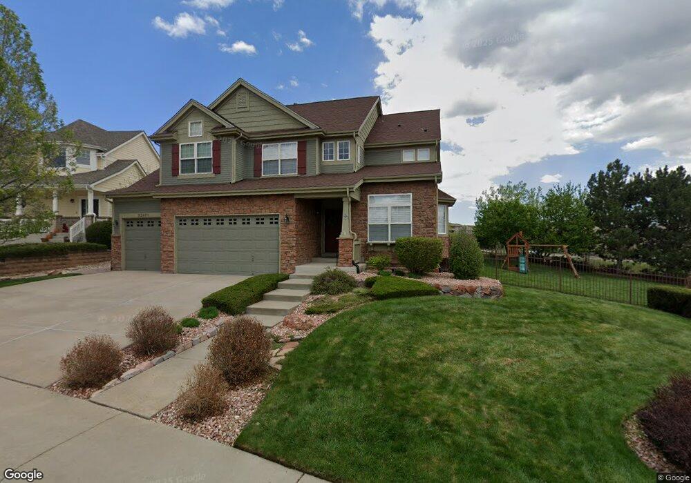
22971 E Euclid Cir Aurora, CO 80016
Saddle Rock NeighborhoodEstimated Value: $756,734 - $963,000
4
Beds
5
Baths
2,890
Sq Ft
$298/Sq Ft
Est. Value
About This Home
This home is located at 22971 E Euclid Cir, Aurora, CO 80016 and is currently estimated at $860,684, approximately $297 per square foot. 22971 E Euclid Cir is a home located in Arapahoe County with nearby schools including Creekside Elementary School, Liberty Middle School, and Grandview High School.
Ownership History
Date
Name
Owned For
Owner Type
Purchase Details
Closed on
Sep 18, 2007
Sold by
Mowbray Cameron and Mowbray Lisa L
Bought by
Anderson Bryce W and Anderson Jessica L
Current Estimated Value
Home Financials for this Owner
Home Financials are based on the most recent Mortgage that was taken out on this home.
Original Mortgage
$359,000
Outstanding Balance
$227,992
Interest Rate
6.63%
Mortgage Type
Purchase Money Mortgage
Estimated Equity
$632,692
Purchase Details
Closed on
Aug 21, 2002
Sold by
Infinity Communities At Saddle Rock Llc
Bought by
Mowbray Cameron and Mowbray Lisa L
Home Financials for this Owner
Home Financials are based on the most recent Mortgage that was taken out on this home.
Original Mortgage
$300,700
Interest Rate
6.48%
Create a Home Valuation Report for This Property
The Home Valuation Report is an in-depth analysis detailing your home's value as well as a comparison with similar homes in the area
Home Values in the Area
Average Home Value in this Area
Purchase History
| Date | Buyer | Sale Price | Title Company |
|---|---|---|---|
| Anderson Bryce W | $425,000 | Fahtco | |
| Mowbray Cameron | $380,900 | -- |
Source: Public Records
Mortgage History
| Date | Status | Borrower | Loan Amount |
|---|---|---|---|
| Open | Anderson Bryce W | $359,000 | |
| Previous Owner | Mowbray Cameron | $300,700 |
Source: Public Records
Tax History Compared to Growth
Tax History
| Year | Tax Paid | Tax Assessment Tax Assessment Total Assessment is a certain percentage of the fair market value that is determined by local assessors to be the total taxable value of land and additions on the property. | Land | Improvement |
|---|---|---|---|---|
| 2024 | $6,176 | $54,036 | -- | -- |
| 2023 | $6,176 | $54,036 | $0 | $0 |
| 2022 | $5,011 | $39,496 | $0 | $0 |
| 2021 | $5,009 | $39,496 | $0 | $0 |
| 2020 | $4,950 | $39,518 | $0 | $0 |
| 2019 | $4,849 | $39,518 | $0 | $0 |
| 2018 | $4,738 | $36,994 | $0 | $0 |
| 2017 | $4,701 | $36,994 | $0 | $0 |
| 2016 | $4,421 | $33,425 | $0 | $0 |
| 2015 | $4,261 | $33,425 | $0 | $0 |
| 2014 | $3,831 | $27,852 | $0 | $0 |
| 2013 | -- | $31,110 | $0 | $0 |
Source: Public Records
Map
Nearby Homes
- 22742 E Calhoun Place
- 6725 S Versailles Way Unit 103
- 6722 S Winnipeg Cir Unit 103
- 22675 E Ontario Dr Unit 202
- 22675 E Ontario Dr Unit 104
- 22771 E Briarwood Place
- 22801 E Briarwood Place
- 22545 E Ontario Dr Unit 103
- 22610 E Ontario Dr Unit 102
- 22580 E Ontario Dr Unit 104
- 22580 E Ontario Dr Unit 103
- 6842 S Algonquian Ct
- 22560 E Ontario Dr Unit 204
- 23464 E Ontario Place
- 6560 S Addison Way
- 6731 S Tempe Ct
- 6552 S Biloxi Way
- 7041 S Valdai St
- 7036 S Gun Club Ct
- 22754 E Rowland Dr
- 22961 E Euclid Cir
- 22896 E Calhoun Place
- 22951 E Euclid Cir
- 22886 E Calhoun Place
- 22858 E Euclid Cir
- 22898 E Euclid Cir
- 22898 E Euclid Cir Unit ID1057091P
- 22868 E Euclid Cir
- 22941 E Euclid Cir
- 23025 E Ontario Dr Unit 106
- 23025 E Ontario Dr Unit 105
- 23025 E Ontario Dr Unit 104
- 23025 E Ontario Dr Unit 103
- 23025 E Ontario Dr Unit 102
- 23025 E Ontario Dr Unit 101
- 23025 E Ontario Dr Unit 7103
- 22878 E Euclid Cir
- 23003 E Ontario Dr Unit 106
- 23003 E Ontario Dr Unit 105
- 23003 E Ontario Dr Unit 104