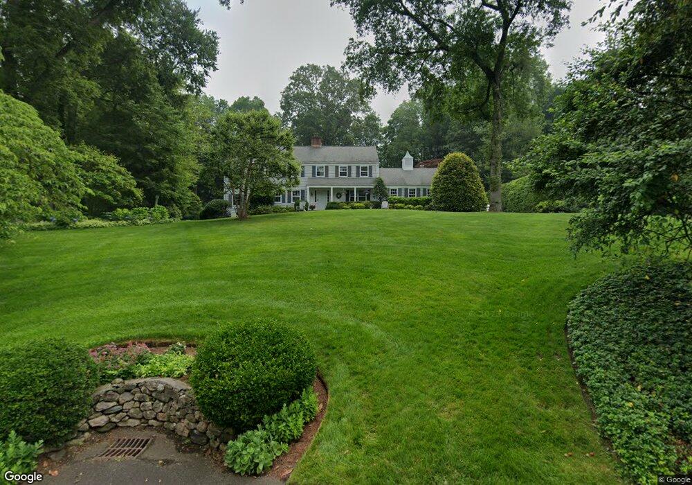
23 Briar Brae Rd Darien, CT 06820
Estimated Value: $1,725,000 - $3,035,000
4
Beds
3
Baths
2,808
Sq Ft
$852/Sq Ft
Est. Value
About This Home
This home is located at 23 Briar Brae Rd, Darien, CT 06820 and is currently estimated at $2,391,824, approximately $851 per square foot. 23 Briar Brae Rd is a home located in Fairfield County with nearby schools including Holmes Elementary School, Middlesex Middle School, and Darien High School.
Ownership History
Date
Name
Owned For
Owner Type
Purchase Details
Closed on
Jul 5, 1988
Sold by
Woods Robert
Bought by
Yezzi Anthony
Current Estimated Value
Home Financials for this Owner
Home Financials are based on the most recent Mortgage that was taken out on this home.
Original Mortgage
$350,000
Interest Rate
10.47%
Create a Home Valuation Report for This Property
The Home Valuation Report is an in-depth analysis detailing your home's value as well as a comparison with similar homes in the area
Home Values in the Area
Average Home Value in this Area
Purchase History
| Date | Buyer | Sale Price | Title Company |
|---|---|---|---|
| Yezzi Anthony | $595,000 | -- |
Source: Public Records
Mortgage History
| Date | Status | Borrower | Loan Amount |
|---|---|---|---|
| Closed | Yezzi Anthony | $380,000 | |
| Closed | Yezzi Anthony | $380,000 | |
| Closed | Yezzi Anthony | $350,000 |
Source: Public Records
Tax History
| Year | Tax Paid | Tax Assessment Tax Assessment Total Assessment is a certain percentage of the fair market value that is determined by local assessors to be the total taxable value of land and additions on the property. | Land | Improvement |
|---|---|---|---|---|
| 2025 | $17,875 | $1,154,720 | $764,050 | $390,670 |
| 2024 | $16,963 | $1,154,720 | $764,050 | $390,670 |
| 2023 | $15,038 | $853,930 | $545,790 | $308,140 |
| 2022 | $14,713 | $853,930 | $545,790 | $308,140 |
| 2021 | $0 | $853,930 | $545,790 | $308,140 |
| 2020 | $13,970 | $853,930 | $545,790 | $308,140 |
| 2019 | $14,064 | $853,930 | $545,790 | $308,140 |
| 2018 | $0 | $903,980 | $556,150 | $347,830 |
| 2017 | $14,608 | $903,980 | $556,150 | $347,830 |
| 2016 | $14,256 | $903,980 | $556,150 | $347,830 |
| 2015 | $13,876 | $903,980 | $556,150 | $347,830 |
| 2014 | $13,569 | $903,980 | $556,150 | $347,830 |
Source: Public Records
Map
Nearby Homes
- 19 Georgian Ln
- 15 Waterbury Ln
- 112 Camp Ave
- 910 Hope St Unit 5B
- 76 Deepwood Rd
- 7 Barnstable Ln
- 17 Sunnyside Ave
- 85 Camp Ave Unit 10I
- 27 Northill St Unit 5N
- 72 Highview Ave
- 17 Oenoke Place
- 1197 Hope St Unit 3
- 179 Highview Ave Unit 2
- 1230 Hope St Unit 7
- 39 Woodway Rd Unit C7
- 223 Middlesex Rd
- 59 Woodway Rd Unit 1
- 130 Mulberry St
- 100 Maple Tree Ave Unit 7
- 49 Minivale Rd
- 25 Briar Brae Rd
- 21 Briar Brae Rd
- 44 Leeuwarden Rd
- 48 Leeuwarden Rd
- 27 Briar Brae Rd
- 34 Leeuwarden Rd
- 34 Leeuwarden Rd
- 54 Leeuwarden Rd
- 19 Briar Brae Rd
- 20 Briar Brae Rd
- 7 Leeuwarden Ln
- 120 Leeuwarden Rd
- 29 Briar Brae Rd
- 28 Briar Brae Rd
- 17 Briar Brae Rd
- 62 Leeuwarden Rd
- 18 Briar Brae Rd
- 116 Leeuwarden Rd
- 36 Briar Brae Rd
- 31 Briar Brae Rd
Your Personal Tour Guide
Ask me questions while you tour the home.