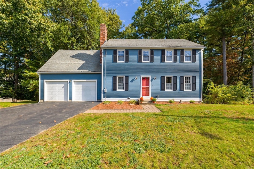
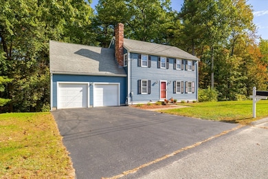
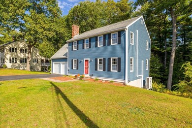
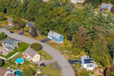
23 Lantern Ln Leominster, MA 01453
Estimated payment $3,582/month
Highlights
- Golf Course Community
- Colonial Architecture
- Property is near public transit and schools
- Medical Services
- Deck
- Wood Flooring
About This Home
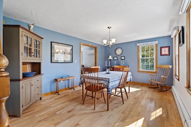
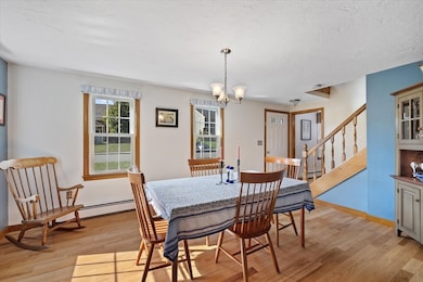
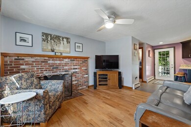
This home is ready to welcome new owners who will love it just as much as the current ones have! Tucked away in a tranquil neighborhood on Leominster’s south side, it offers the perfect mix of modern updates and classic charm. From the attached two-car garage, step into a beautiful kitchen with ceiling-height cabinetry, granite countertops, and stainless steel appliances. The first floor features a spacious living room, a dining area with a fireplace, and a cozy sitting room that’s perfect for the holidays or a relaxing night in. Upstairs, you’ll find four comfortable bedrooms, each with its own mini split for heating and cooling. The primary suite includes a full bathroom, a walk-in closet, and rich maple hardwood floors. Located close to Routes 190, 290, and 2, this home makes commuting easy while keeping you near everything Leominster has to offer.Come see how this beautifully cared-for colonial combines comfort, character, and modern style in a place you’ll love to call home!

Home Details
Home Type
- Single Family
Est. Annual Taxes
- $6,457
Year Built
- Built in 1986 | Remodeled
Lot Details
- 0.39 Acre Lot
- Cul-De-Sac
- Level Lot
- Sprinkler System
- Property is zoned RA
Parking
- 2 Car Attached Garage
- 4 Open Parking Spaces
- Off-Street Parking
Home Design
- Colonial Architecture
- Frame Construction
- Blown-In Insulation
- Shingle Roof
- Concrete Perimeter Foundation
Interior Spaces
- Recessed Lighting
- Light Fixtures
- Insulated Windows
- Dining Room with Fireplace
- Washer and Electric Dryer Hookup
- Attic
Kitchen
- Range
- Microwave
- Dishwasher
Flooring
- Wood
- Ceramic Tile
- Vinyl
Bedrooms and Bathrooms
- 4 Bedrooms
- Primary bedroom located on second floor
- Walk-In Closet
Partially Finished Basement
- Walk-Out Basement
- Basement Fills Entire Space Under The House
- Laundry in Basement
Outdoor Features
- Deck
- Rain Gutters
Location
- Property is near public transit and schools
Schools
- Fall Brook Elementary School
- Samoset Middle School
- Leominster High School
Utilities
- Ductless Heating Or Cooling System
- 4 Cooling Zones
- 3 Heating Zones
- Heating System Uses Oil
- Baseboard Heating
- 100 Amp Service
- Electric Water Heater
Listing and Financial Details
- Assessor Parcel Number M:0456 B:0010A L:0000,1586589
Community Details
Overview
- No Home Owners Association
- Near Conservation Area
Amenities
- Medical Services
- Shops
- Coin Laundry
Recreation
- Golf Course Community
- Tennis Courts
- Community Pool
- Park
- Jogging Path
- Bike Trail
Map
Home Values in the Area
Average Home Value in this Area
Tax History
| Year | Tax Paid | Tax Assessment Tax Assessment Total Assessment is a certain percentage of the fair market value that is determined by local assessors to be the total taxable value of land and additions on the property. | Land | Improvement |
|---|---|---|---|---|
| 2025 | $6,457 | $460,200 | $148,800 | $311,400 |
| 2024 | $6,368 | $438,900 | $141,700 | $297,200 |
| 2023 | $6,019 | $387,300 | $123,200 | $264,100 |
| 2022 | $5,730 | $346,000 | $107,100 | $238,900 |
| 2021 | $5,392 | $297,400 | $83,400 | $214,000 |
| 2020 | $5,153 | $286,600 | $83,400 | $203,200 |
| 2019 | $5,004 | $269,900 | $79,500 | $190,400 |
| 2018 | $4,968 | $257,000 | $77,200 | $179,800 |
| 2017 | $4,802 | $243,400 | $72,100 | $171,300 |
| 2016 | $4,725 | $241,300 | $72,100 | $169,200 |
| 2015 | $4,355 | $224,000 | $72,100 | $151,900 |
| 2014 | $4,286 | $226,900 | $79,600 | $147,300 |
Property History
| Date | Event | Price | List to Sale | Price per Sq Ft |
|---|---|---|---|---|
| 10/19/2025 10/19/25 | Pending | -- | -- | -- |
| 10/08/2025 10/08/25 | For Sale | $585,000 | -- | $233 / Sq Ft |
Purchase History
| Date | Type | Sale Price | Title Company |
|---|---|---|---|
| Deed | $132,000 | -- | |
| Deed | $5,000 | -- | |
| Deed | $174,000 | -- |
Mortgage History
| Date | Status | Loan Amount | Loan Type |
|---|---|---|---|
| Closed | $106,000 | No Value Available | |
| Closed | $127,500 | No Value Available | |
| Closed | $10,000 | No Value Available |
Source: MLS Property Information Network (MLS PIN)
MLS Number: 73441150
APN: LEOM-000456-000010A
Disclaimer: Certain information contained herein is derived from information provided by parties other than Homes.com. All information provided is deemed reliable, but is not guaranteed to be accurate and should be independently verified.
![]() The property listing data and information, or the Images, set forth herein were provided to MLS Property Information Network, Inc. from third party sources, including sellers, lessors and public records, and were compiled by MLS Property Information Network, Inc. The property listing data and information, and the Images, are for the personal, non-commercial use of consumers having a good faith interest in purchasing or leasing listed properties of the type displayed to them and may not be used for any purpose other than to identify prospective properties which such consumers may have a good faith interest in purchasing or leasing. MLS Property Information Network, Inc. and its subscribers disclaim any and all representations and warranties as to the accuracy of the property listing data and information, or as to the accuracy of any of the Images, set forth herein.
The property listing data and information, or the Images, set forth herein were provided to MLS Property Information Network, Inc. from third party sources, including sellers, lessors and public records, and were compiled by MLS Property Information Network, Inc. The property listing data and information, and the Images, are for the personal, non-commercial use of consumers having a good faith interest in purchasing or leasing listed properties of the type displayed to them and may not be used for any purpose other than to identify prospective properties which such consumers may have a good faith interest in purchasing or leasing. MLS Property Information Network, Inc. and its subscribers disclaim any and all representations and warranties as to the accuracy of the property listing data and information, or as to the accuracy of any of the Images, set forth herein.
- 675 Willard St
- 40 Biscayne St
- 372 Litchfield St
- 193 Bayberry Hill Ln
- 6 Chapman Place
- 30 Abbey Rd Unit 202
- 779 Willard St
- 25 Meadow Pond Dr Unit j
- 103 Keeneland Cir
- 851 Lancaster St
- 93 Pennacook Dr
- 6 Longwood Ave
- 60 Howard St
- 99 Cortland Cir
- 46 Eugene St
- 41 Hill St
- 0 Wheeler St
- 42 Wheeler St
- 21 Regina Dr
- 0 Johnson St
Ask me questions while you tour the home.