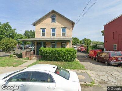
23 Leonard St Norwalk, CT 06850
Downtown Norwalk NeighborhoodEstimated Value: $538,000 - $762,186
3
Beds
2
Baths
2,238
Sq Ft
$300/Sq Ft
Est. Value
About This Home
This home is located at 23 Leonard St, Norwalk, CT 06850 and is currently estimated at $672,047, approximately $300 per square foot. 23 Leonard St is a home located in Fairfield County with nearby schools including Tracey School, West Rocks Middle School, and Norwalk High School.
Ownership History
Date
Name
Owned For
Owner Type
Purchase Details
Closed on
Jun 10, 2016
Sold by
Mutual Housing Assoc
Bought by
Devine Brothers Incorp
Current Estimated Value
Purchase Details
Closed on
Nov 3, 2005
Sold by
Fairfield County Hsng
Bought by
Action Hsng Inc
Home Financials for this Owner
Home Financials are based on the most recent Mortgage that was taken out on this home.
Original Mortgage
$100,000
Interest Rate
4%
Purchase Details
Closed on
Jun 17, 1993
Sold by
Scapecia Mary
Bought by
Fairfield Cty Mutual
Create a Home Valuation Report for This Property
The Home Valuation Report is an in-depth analysis detailing your home's value as well as a comparison with similar homes in the area
Home Values in the Area
Average Home Value in this Area
Purchase History
| Date | Buyer | Sale Price | Title Company |
|---|---|---|---|
| Devine Brothers Incorp | $370,000 | -- | |
| Devine Brothers Incorp | $370,000 | -- | |
| Action Hsng Inc | $240,000 | -- | |
| Action Hsng Inc | $240,000 | -- | |
| Fairfield Cty Mutual | $125,000 | -- | |
| Fairfield Cty Mutual | $125,000 | -- |
Source: Public Records
Mortgage History
| Date | Status | Borrower | Loan Amount |
|---|---|---|---|
| Previous Owner | Fairfield Cty Mutual | $100,000 |
Source: Public Records
Tax History Compared to Growth
Tax History
| Year | Tax Paid | Tax Assessment Tax Assessment Total Assessment is a certain percentage of the fair market value that is determined by local assessors to be the total taxable value of land and additions on the property. | Land | Improvement |
|---|---|---|---|---|
| 2024 | $8,759 | $372,010 | $146,730 | $225,280 |
| 2023 | $5,990 | $238,760 | $115,290 | $123,470 |
| 2022 | $5,860 | $238,760 | $115,290 | $123,470 |
| 2021 | $5,723 | $238,760 | $115,290 | $123,470 |
| 2020 | $5,720 | $238,760 | $115,290 | $123,470 |
| 2019 | $5,567 | $238,760 | $115,290 | $123,470 |
| 2018 | $5,467 | $205,500 | $119,700 | $85,800 |
| 2017 | $5,278 | $205,500 | $119,700 | $85,800 |
| 2016 | $5,268 | $207,060 | $119,700 | $87,360 |
| 2015 | $5,214 | $205,500 | $119,700 | $85,800 |
| 2014 | $5,146 | $205,500 | $119,700 | $85,800 |
Source: Public Records
Map
Nearby Homes
- 19 Isaacs St Unit 301
- 22 Leonard St
- 30 Merwin St Unit 6
- 30 Merwin St Unit 10
- 9 Park St Unit 2A (door 201)
- 142 East Ave Unit A101
- 142 East Ave Unit 303
- 29 Van Buren Ave Unit L6
- 29 Van Buren Ave Unit H2
- 0 Highway 7 Unit 160027
- 14 Jefferson St
- 27 Bettswood Rd
- 41 Parkhill Ave
- 1 Armstrong Ct
- 16 1/2 W Main St
- 19 Fairview Ave Unit A
- 2 Olmstead Place
- 33 Macintosh Rd
- 29 Spruce St
- 16 Hill St
- 23 Leonard St
- 19 Isaacs St Unit 408
- 19 Isaacs St Unit 407
- 19 Isaacs St Unit 406
- 19 Isaacs St Unit 405
- 19 Isaacs St Unit 404
- 19 Isaacs St Unit 403
- 19 Isaacs St Unit 402
- 19 Isaacs St Unit 401
- 19 Isaacs St Unit 400
- 19 Isaacs St Unit 308
- 19 Isaacs St Unit 307
- 19 Isaacs St Unit 306
- 19 Isaacs St Unit 305
- 19 Isaacs St Unit 304
- 19 Isaacs St Unit 303
- 19 Isaacs St Unit 302
- 19 Isaacs St Unit 300
- 19 Isaacs St Unit 207
- 19 Isaacs St Unit 206