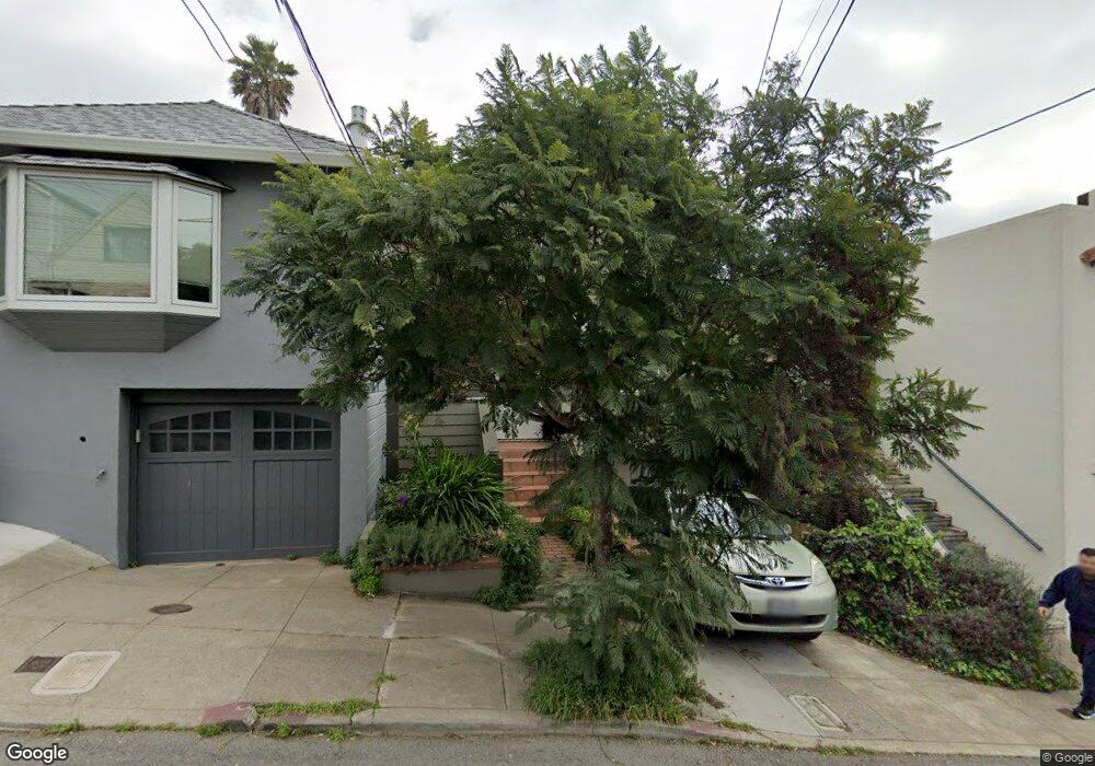
23 Porter St San Francisco, CA 94110
Bernal Heights NeighborhoodEstimated Value: $1,013,000 - $1,474,000
--
Bed
1
Bath
1,100
Sq Ft
$1,051/Sq Ft
Est. Value
About This Home
This home is located at 23 Porter St, San Francisco, CA 94110 and is currently estimated at $1,156,397, approximately $1,051 per square foot. 23 Porter St is a home located in San Francisco County with nearby schools including Serra (Junipero) Elementary School, Hoover (Herbert) Middle School, and St. Paul's School.
Ownership History
Date
Name
Owned For
Owner Type
Purchase Details
Closed on
May 26, 1998
Sold by
Jalalian Armen H
Bought by
Flores Edgard and Hardecker Laura
Current Estimated Value
Home Financials for this Owner
Home Financials are based on the most recent Mortgage that was taken out on this home.
Original Mortgage
$283,500
Outstanding Balance
$57,111
Interest Rate
7.13%
Estimated Equity
$1,099,286
Purchase Details
Closed on
May 23, 1998
Sold by
Jalalian Souzan Oustayan
Bought by
Jalalian Armen H
Home Financials for this Owner
Home Financials are based on the most recent Mortgage that was taken out on this home.
Original Mortgage
$283,500
Outstanding Balance
$57,111
Interest Rate
7.13%
Estimated Equity
$1,099,286
Create a Home Valuation Report for This Property
The Home Valuation Report is an in-depth analysis detailing your home's value as well as a comparison with similar homes in the area
Home Values in the Area
Average Home Value in this Area
Purchase History
| Date | Buyer | Sale Price | Title Company |
|---|---|---|---|
| Flores Edgard | $315,000 | Commonwealth Land Title Co | |
| Jalalian Armen H | -- | Commonwealth Land Title Co |
Source: Public Records
Mortgage History
| Date | Status | Borrower | Loan Amount |
|---|---|---|---|
| Open | Flores Edgard | $283,500 |
Source: Public Records
Tax History Compared to Growth
Tax History
| Year | Tax Paid | Tax Assessment Tax Assessment Total Assessment is a certain percentage of the fair market value that is determined by local assessors to be the total taxable value of land and additions on the property. | Land | Improvement |
|---|---|---|---|---|
| 2025 | $7,262 | $563,630 | $351,276 | $212,354 |
| 2024 | $7,262 | $552,580 | $344,389 | $208,191 |
| 2023 | $7,146 | $541,747 | $337,637 | $204,110 |
| 2022 | $6,998 | $531,126 | $331,017 | $200,109 |
| 2021 | $6,871 | $520,713 | $324,527 | $196,186 |
| 2020 | $6,967 | $515,376 | $321,200 | $194,176 |
| 2019 | $6,733 | $505,272 | $314,902 | $190,370 |
| 2018 | $6,505 | $495,366 | $308,728 | $186,638 |
| 2017 | $6,130 | $485,655 | $302,675 | $182,980 |
| 2016 | $6,007 | $476,134 | $296,741 | $179,393 |
| 2015 | $5,928 | $468,983 | $292,284 | $176,699 |
| 2014 | $5,774 | $459,797 | $286,559 | $173,238 |
Source: Public Records
Map
Nearby Homes
- 104 Bache St Unit A
- 141 Porter St
- 132 Bache St
- 886 Moultrie St
- 881 Moultrie St
- 607 Anderson St
- 363 Park St
- 4136 Folsom St
- 480 Andover St
- 251 Richland Ave
- 656 Banks St
- 334 Alemany Blvd Unit 3
- 71 Gladstone Dr
- 38 Colby St
- 125 Leese St
- 479 Gates St
- 46 Dartmouth St
- 129 Ellert St Unit 1/2
- 73 Leese St
- 3954 Folsom St