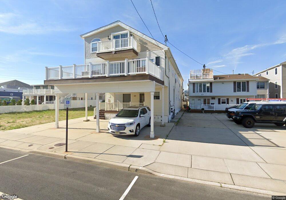
23 Sampson Ave Seaside Heights, NJ 08751
Estimated Value: $1,070,000 - $1,601,000
9
Beds
7
Baths
4,540
Sq Ft
$293/Sq Ft
Est. Value
About This Home
This home is located at 23 Sampson Ave, Seaside Heights, NJ 08751 and is currently estimated at $1,329,536, approximately $292 per square foot. 23 Sampson Ave is a home located in Ocean County with nearby schools including Hugh J. Boyd Jr. Elementary School, Central Regional Middle School, and Central Regional High School.
Ownership History
Date
Name
Owned For
Owner Type
Purchase Details
Closed on
Jul 22, 2024
Sold by
Pizzuti Robert
Bought by
Robert And Eleanor Pizzuti Revocable Trust
Current Estimated Value
Purchase Details
Closed on
Dec 10, 2003
Sold by
Scarillo Judith M
Bought by
Pizzuti Robert and Pizzuti Eleanor
Purchase Details
Closed on
Mar 29, 1999
Sold by
Scarillo Judith M
Bought by
Scarillo Judith M and Ippolito Martin J
Create a Home Valuation Report for This Property
The Home Valuation Report is an in-depth analysis detailing your home's value as well as a comparison with similar homes in the area
Home Values in the Area
Average Home Value in this Area
Purchase History
| Date | Buyer | Sale Price | Title Company |
|---|---|---|---|
| Robert And Eleanor Pizzuti Revocable Trust | -- | Techno Title | |
| Pizzuti Robert | $315,500 | -- | |
| Scarillo Judith M | -- | -- |
Source: Public Records
Tax History Compared to Growth
Tax History
| Year | Tax Paid | Tax Assessment Tax Assessment Total Assessment is a certain percentage of the fair market value that is determined by local assessors to be the total taxable value of land and additions on the property. | Land | Improvement |
|---|---|---|---|---|
| 2025 | $15,672 | $1,204,200 | $600,000 | $604,200 |
| 2024 | $14,294 | $553,000 | $180,000 | $373,000 |
| 2023 | $13,581 | $553,000 | $180,000 | $373,000 |
| 2022 | $13,831 | $553,000 | $180,000 | $373,000 |
| 2021 | $12,233 | $553,000 | $180,000 | $373,000 |
| 2020 | $13,427 | $553,000 | $180,000 | $373,000 |
| 2019 | $13,023 | $553,000 | $180,000 | $373,000 |
| 2018 | $12,680 | $553,000 | $180,000 | $373,000 |
| 2017 | $12,443 | $553,000 | $180,000 | $373,000 |
| 2016 | $12,232 | $553,000 | $180,000 | $373,000 |
| 2015 | $11,807 | $553,000 | $180,000 | $373,000 |
| 2014 | $10,811 | $553,000 | $180,000 | $373,000 |
Source: Public Records
Map
Nearby Homes
- 55 Sampson Ave
- 45 Sampson Ave Unit 11
- 51 Sampson Ave
- 36 Kearney Ave
- 52 Kearney Ave
- 61 Hiering Ave
- 51 Hiering Ave Unit D-4
- 1501 Ocean Terrace Unit H
- 1300 Ocean Terrace
- 500 Ocean Terrace Unit 6
- 500 Ocean Terrace Unit 9
- 500 Ocean Terrace Unit 1
- 1515 Boulevard Unit 13
- 28 Fremont Ave Unit 14
- 28 Fremont Ave Unit 8
- 28 Fremont Ave Unit 12
- 1601 Boulevard Unit B7
- 112 Kearney Ave
- 118 Sampson Ave
- 1215 Boulevard
- 27 Sampson Ave
- 27 Sampson Ave Unit 1st floor
- 27 Sampson Ave Unit 2nd Floor
- 21 Sampson Ave
- 17 Sampson Ave
- 17 Sampson Ave Unit 1 & 2
- 17 Sampson Ave Unit Lower
- 33 Sampson Ave
- 22 Carteret Ave
- 20 Carteret Ave
- 28 Carteret Ave Unit 32
- 28 Carteret Ave Unit 32
- 28 Carteret Ave Unit 32
- 28 Carteret Ave Unit 32
- 28 Carteret Ave Unit 32
- 28 Carteret Ave Unit 2
- 28 Carteret Ave Unit 5
- 28 Carteret Ave Unit 4
- 28 Carteret Ave
- 28 Carteret Ave Unit UPPER