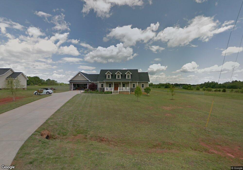
230 Burnt Tanyard Rd West Union, SC 29696
Estimated Value: $338,000 - $610,000
4
Beds
3
Baths
2,550
Sq Ft
$182/Sq Ft
Est. Value
About This Home
This home is located at 230 Burnt Tanyard Rd, West Union, SC 29696 and is currently estimated at $464,077, approximately $181 per square foot. 230 Burnt Tanyard Rd is a home located in Oconee County with nearby schools including Keowee Elementary School, Walhalla Middle School, and Walhalla High School.
Ownership History
Date
Name
Owned For
Owner Type
Purchase Details
Closed on
May 13, 2019
Sold by
Townsend Joni
Bought by
The Devon R White Revocable Trust
Current Estimated Value
Purchase Details
Closed on
Mar 28, 2008
Sold by
Crooks Thornton and Crooks Thorntou E
Bought by
Townsend Joni
Home Financials for this Owner
Home Financials are based on the most recent Mortgage that was taken out on this home.
Original Mortgage
$199,500
Interest Rate
6.22%
Mortgage Type
New Conventional
Create a Home Valuation Report for This Property
The Home Valuation Report is an in-depth analysis detailing your home's value as well as a comparison with similar homes in the area
Home Values in the Area
Average Home Value in this Area
Purchase History
| Date | Buyer | Sale Price | Title Company |
|---|---|---|---|
| The Devon R White Revocable Trust | $213,476 | None Available | |
| Townsend Joni | $285,000 | None Available |
Source: Public Records
Mortgage History
| Date | Status | Borrower | Loan Amount |
|---|---|---|---|
| Previous Owner | Townsend Joni | $199,500 |
Source: Public Records
Tax History Compared to Growth
Tax History
| Year | Tax Paid | Tax Assessment Tax Assessment Total Assessment is a certain percentage of the fair market value that is determined by local assessors to be the total taxable value of land and additions on the property. | Land | Improvement |
|---|---|---|---|---|
| 2025 | $934 | $8,902 | $435 | $8,467 |
| 2024 | $934 | $8,902 | $435 | $8,467 |
| 2023 | $946 | $8,902 | $435 | $8,467 |
| 2022 | $946 | $8,902 | $435 | $8,467 |
| 2021 | $1,293 | $8,518 | $516 | $8,002 |
| 2020 | $1,293 | $0 | $0 | $0 |
| 2019 | $1,293 | $0 | $0 | $0 |
| 2018 | $2,578 | $0 | $0 | $0 |
| 2017 | $1,293 | $0 | $0 | $0 |
| 2016 | $1,293 | $0 | $0 | $0 |
| 2015 | -- | $0 | $0 | $0 |
| 2014 | -- | $12,328 | $1,226 | $11,102 |
| 2013 | -- | $0 | $0 | $0 |
Source: Public Records
Map
Nearby Homes
- 2357 Pickens Hwy
- 270 Colony Ln
- 00 Colony Ln
- TBD Colony Ln
- 595 Morris Ln
- 665 Brc Dr
- 108 Cranes Crossing Dr
- 00 (Corner) Hwy 183 Keowee School Rd
- TBD Colony Ln
- 00 Wolf Stake Church Rd
- 000 Wolf Stake Church Rd
- 299 Springbrook Rd
- 150 Cedar Hill Dr
- 1907 Queen Dr
- 1817 Hastehill Dr
- 310 Falcons Nest Rd
- Hudson Plan at Windsor Estates
- Bramante Ranch Plan at Windsor Estates
- Savannah Plan at Windsor Estates
- Columbia Plan at Windsor Estates
- 234 Burnt Tanyard Rd
- 220 Burnt Tanyard Rd
- 236 Burnt Tanyard Rd
- 238 Burnt Tanyard Rd
- 221 Burnt Tanyard Rd
- 240 Burnt Tanyard Rd
- 108 Old Station Rd
- 104 Old Station Rd
- 110 Old Station Rd
- 241 Burnt Tanyard Rd
- 106 Old Station Rd
- 114 Old Station Rd
- 112 Old Station Rd
- 254 Windy Meadows Ln
- 234 Windy Meadows Ln
- 125 Old Station Rd
- 226 Windy Meadows Ln
- 127 Old Station Rd
- 218 Windy Meadows Ln
- 242 Windy Meadows Ln