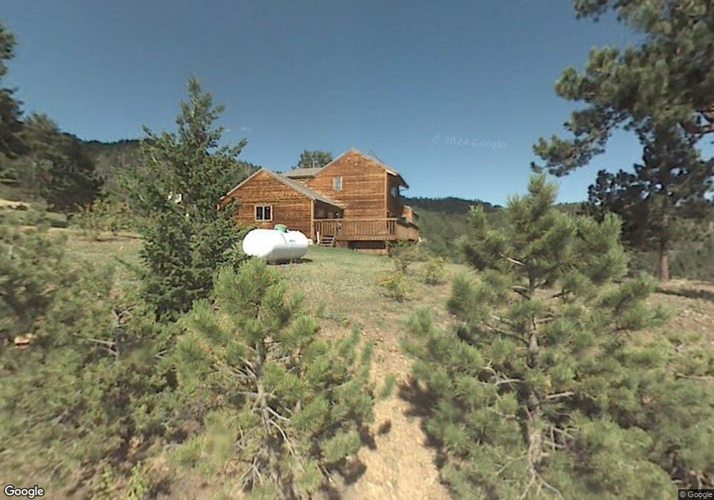
230 Nightshade Dr Boulder, CO 80302
Estimated Value: $760,000 - $1,068,000
4
Beds
4
Baths
2,280
Sq Ft
$404/Sq Ft
Est. Value
About This Home
This home is located at 230 Nightshade Dr, Boulder, CO 80302 and is currently estimated at $922,026, approximately $404 per square foot. 230 Nightshade Dr is a home located in Boulder County with nearby schools including Nederland Elementary School and Nederland Middle-Senior High School.
Ownership History
Date
Name
Owned For
Owner Type
Purchase Details
Closed on
Apr 2, 1996
Sold by
Evans Gregory Blair and Evans Elizabeth Lynn Torray
Bought by
Yoksas Thomas C
Current Estimated Value
Home Financials for this Owner
Home Financials are based on the most recent Mortgage that was taken out on this home.
Original Mortgage
$157,000
Outstanding Balance
$7,390
Interest Rate
7.35%
Estimated Equity
$914,636
Purchase Details
Closed on
Dec 10, 1986
Bought by
Yoksas Thomas C
Purchase Details
Closed on
May 12, 1986
Bought by
Yoksas Thomas C
Purchase Details
Closed on
Nov 8, 1984
Bought by
Yoksas Thomas C
Create a Home Valuation Report for This Property
The Home Valuation Report is an in-depth analysis detailing your home's value as well as a comparison with similar homes in the area
Purchase History
| Date | Buyer | Sale Price | Title Company |
|---|---|---|---|
| Yoksas Thomas C | $267,250 | Land Title | |
| Yoksas Thomas C | -- | -- | |
| Yoksas Thomas C | $171,500 | -- | |
| Yoksas Thomas C | $25,000 | -- |
Source: Public Records
Mortgage History
| Date | Status | Borrower | Loan Amount |
|---|---|---|---|
| Open | Yoksas Thomas C | $157,000 |
Source: Public Records
Tax History
| Year | Tax Paid | Tax Assessment Tax Assessment Total Assessment is a certain percentage of the fair market value that is determined by local assessors to be the total taxable value of land and additions on the property. | Land | Improvement |
|---|---|---|---|---|
| 2025 | $4,430 | $53,919 | $9,925 | $43,994 |
| 2024 | $4,430 | $53,919 | $9,925 | $43,994 |
| 2023 | $4,941 | $56,347 | $9,541 | $50,491 |
| 2022 | $4,449 | $47,101 | $7,972 | $39,129 |
| 2021 | $4,402 | $48,456 | $8,201 | $40,255 |
| 2020 | $3,564 | $38,703 | $10,511 | $28,192 |
| 2019 | $3,509 | $38,703 | $10,511 | $28,192 |
| 2018 | $2,719 | $29,930 | $7,344 | $22,586 |
| 2017 | $2,650 | $33,090 | $8,119 | $24,971 |
| 2016 | $2,774 | $30,455 | $8,119 | $22,336 |
| 2015 | $2,630 | $32,596 | $11,462 | $21,134 |
| 2014 | $2,949 | $32,596 | $11,462 | $21,134 |
Source: Public Records
Map
Nearby Homes
- 5566 Sugarloaf Rd
- 548 Coughlin Meadows Rd
- 815 Cougar Run
- 3907 Ridge Rd
- 0 Pennsylvania Gulch Rd
- 280 Hummer Dr
- 11320 Gold Hill Rd
- 880 Hummer Dr
- 136 Old Post Office Rd
- 0 Good Friday Rd
- 730 Lost Angel Rd
- 11780 Gold Hill Rd
- 0 Gold Trail
- 00 County Rd 89 Unit 237
- 718 Emerson Gulch Rd
- 198 Frontier Ln
- 300 Shining Star Trail
- 300 Shining Star Trail Unit A
- 280 Rim Rd
- 2200 Magnolia Rd
- 193 Nightshade Dr
- 221 Nightshade Dr
- 0 Primos Rd
- 465 Nightshade Dr
- 388 Nightshade Dr
- 545 Nightshade Dr
- 66 Nightshade Dr
- 22 Nightshade Dr
- 458 Nightshade Dr
- 184 Nightshade Dr
- 454 Nightshade Dr
- 862 Primos Rd
- 0 Nightshade Dr
- 729 Primos Rd
- 560 Nightshade Dr
- 144 Coyote Ct
- 146 Coyote Ct
- 875 Primos Rd
- 900 Primos Rd
- 75 Coyote Ct
Your Personal Tour Guide
Ask me questions while you tour the home.