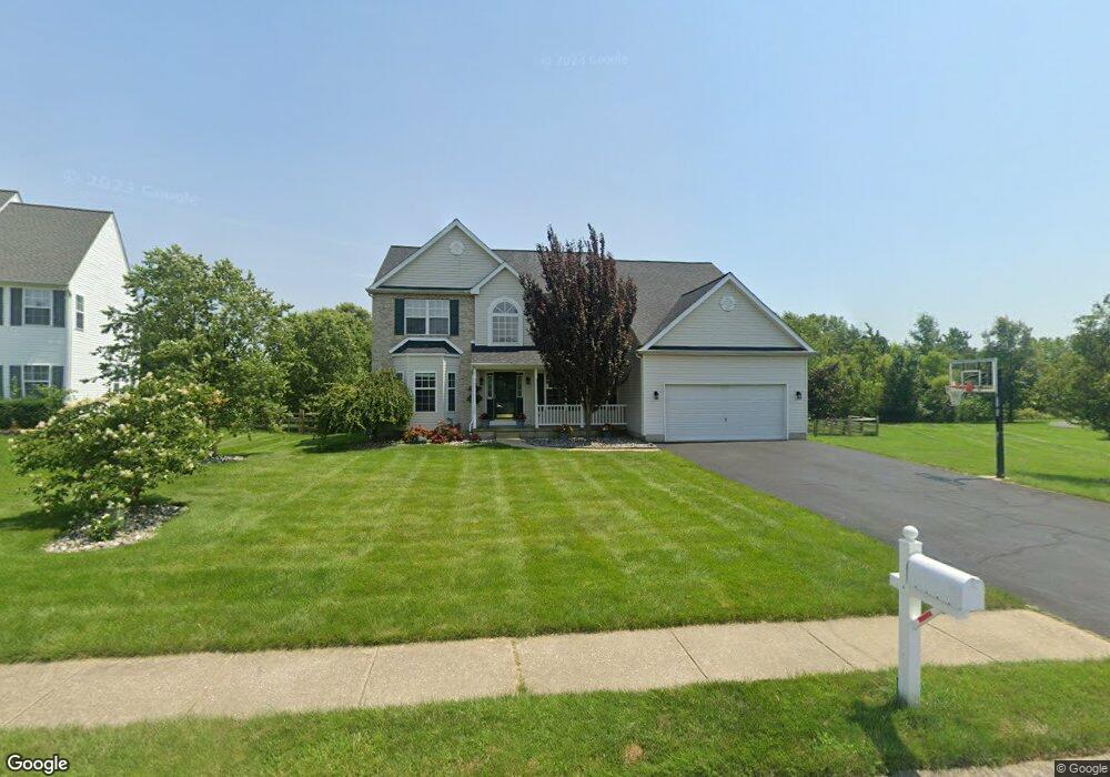
230 Olivine Cir Townsend, DE 19734
Estimated Value: $604,301 - $658,000
4
Beds
3
Baths
2,823
Sq Ft
$223/Sq Ft
Est. Value
About This Home
This home is located at 230 Olivine Cir, Townsend, DE 19734 and is currently estimated at $629,075, approximately $222 per square foot. 230 Olivine Cir is a home located in New Castle County with nearby schools including Old State Elementary School, Cantwell's Bridge Middle School, and Odessa High School.
Ownership History
Date
Name
Owned For
Owner Type
Purchase Details
Closed on
Oct 6, 2004
Sold by
First State Enterprises Inc
Bought by
Benchmark Builders Inc
Current Estimated Value
Purchase Details
Closed on
Jan 7, 2004
Sold by
Benchmark Builders Inc
Bought by
Wojcik Charles P and Wojcik Patricia M
Home Financials for this Owner
Home Financials are based on the most recent Mortgage that was taken out on this home.
Original Mortgage
$253,000
Interest Rate
5.5%
Mortgage Type
Purchase Money Mortgage
Create a Home Valuation Report for This Property
The Home Valuation Report is an in-depth analysis detailing your home's value as well as a comparison with similar homes in the area
Home Values in the Area
Average Home Value in this Area
Purchase History
| Date | Buyer | Sale Price | Title Company |
|---|---|---|---|
| Benchmark Builders Inc | $67,500 | -- | |
| Wojcik Charles P | $374,040 | Stewart Title Guaranty Compa |
Source: Public Records
Mortgage History
| Date | Status | Borrower | Loan Amount |
|---|---|---|---|
| Previous Owner | Wojcik Charles P | $253,000 |
Source: Public Records
Tax History Compared to Growth
Tax History
| Year | Tax Paid | Tax Assessment Tax Assessment Total Assessment is a certain percentage of the fair market value that is determined by local assessors to be the total taxable value of land and additions on the property. | Land | Improvement |
|---|---|---|---|---|
| 2024 | $4,537 | $105,000 | $9,500 | $95,500 |
| 2023 | $3,879 | $105,000 | $9,500 | $95,500 |
| 2022 | $3,885 | $105,000 | $9,500 | $95,500 |
| 2021 | $3,835 | $105,000 | $9,500 | $95,500 |
| 2020 | $3,782 | $105,000 | $9,500 | $95,500 |
| 2019 | $4,090 | $105,000 | $9,500 | $95,500 |
| 2018 | $3,395 | $105,000 | $9,500 | $95,500 |
| 2017 | $3,256 | $105,000 | $9,500 | $95,500 |
| 2016 | $2,967 | $105,000 | $9,500 | $95,500 |
| 2015 | $2,891 | $105,000 | $9,500 | $95,500 |
| 2014 | $2,888 | $105,000 | $9,500 | $95,500 |
Source: Public Records
Map
Nearby Homes
- 1143 Kayla Ln
- 214 Abbigail Crossing
- 1019 Robinson Rd
- 1020 Robinson Rd
- 1027 Robinson Rd
- 1113 Kayla Ln
- 1060 Robinson Rd Unit WHITFIELD PLAN
- 1062 Robinson Rd Unit WHITFIELD RANCH PLAN
- 1064 Robinson Rd Unit LAKELAND PLAN
- 1066 Robinson Rd Unit PEMBROOK PLAN
- 1068 Robinson Rd Unit DELRAY PLAN
- 604 Ravenglass Dr
- 506 Aviemore Dr
- 101 Wedge Ct
- 214 Case Rd
- 208 Aberdeen Way
- 212 Case Rd
- 210 Case Rd
- 1529 Paige Place
- 1531 Paige Place