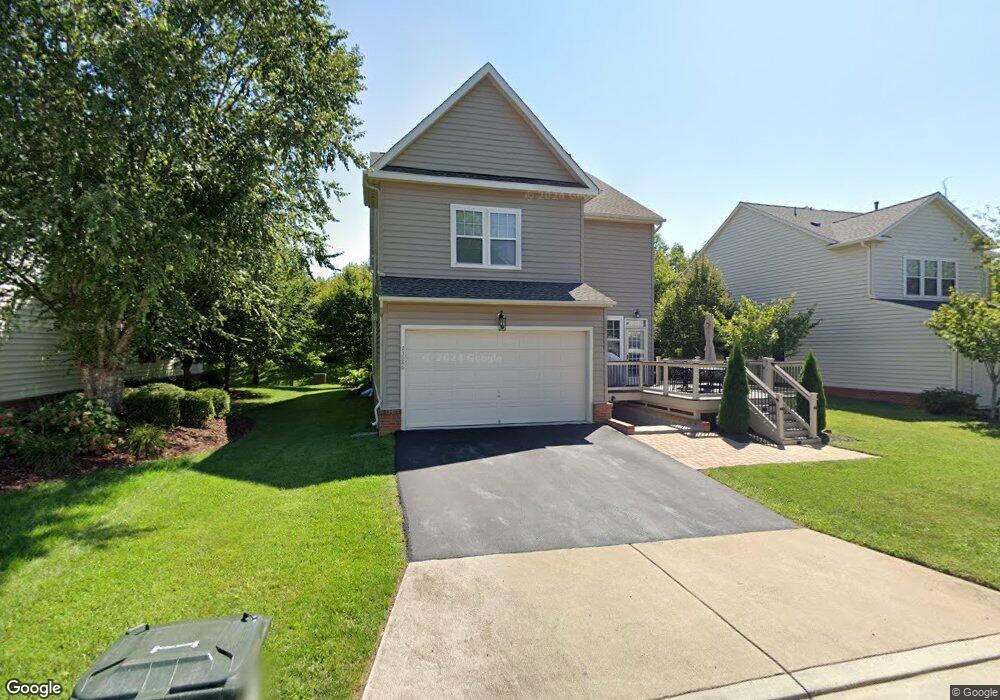
23086 Bronstein Ln Ashburn, VA 20148
Estimated Value: $899,000 - $1,082,000
4
Beds
4
Baths
2,762
Sq Ft
$365/Sq Ft
Est. Value
About This Home
This home is located at 23086 Bronstein Ln, Ashburn, VA 20148 and is currently estimated at $1,007,309, approximately $364 per square foot. 23086 Bronstein Ln is a home located in Loudoun County with nearby schools including Legacy Elementary School, Brambleton Middle School, and Independence High School.
Ownership History
Date
Name
Owned For
Owner Type
Purchase Details
Closed on
Dec 18, 2009
Sold by
Bram Iii Neighborhoods L L C
Bought by
Davis Dalton J E
Current Estimated Value
Home Financials for this Owner
Home Financials are based on the most recent Mortgage that was taken out on this home.
Original Mortgage
$365,000
Outstanding Balance
$239,293
Interest Rate
5%
Mortgage Type
New Conventional
Estimated Equity
$768,016
Create a Home Valuation Report for This Property
The Home Valuation Report is an in-depth analysis detailing your home's value as well as a comparison with similar homes in the area
Home Values in the Area
Average Home Value in this Area
Purchase History
| Date | Buyer | Sale Price | Title Company |
|---|---|---|---|
| Davis Dalton J E | $476,805 | -- |
Source: Public Records
Mortgage History
| Date | Status | Borrower | Loan Amount |
|---|---|---|---|
| Open | Davis Dalton J E | $365,000 |
Source: Public Records
Tax History Compared to Growth
Tax History
| Year | Tax Paid | Tax Assessment Tax Assessment Total Assessment is a certain percentage of the fair market value that is determined by local assessors to be the total taxable value of land and additions on the property. | Land | Improvement |
|---|---|---|---|---|
| 2025 | $7,892 | $980,410 | $320,600 | $659,810 |
| 2024 | $7,879 | $910,830 | $280,600 | $630,230 |
| 2023 | $7,210 | $823,970 | $310,600 | $513,370 |
| 2022 | $7,050 | $792,090 | $270,600 | $521,490 |
| 2021 | $6,705 | $684,150 | $245,600 | $438,550 |
| 2020 | $6,436 | $621,800 | $225,600 | $396,200 |
| 2019 | $6,362 | $608,790 | $225,600 | $383,190 |
| 2018 | $6,306 | $581,230 | $200,600 | $380,630 |
| 2017 | $6,472 | $575,290 | $200,600 | $374,690 |
| 2016 | $6,579 | $574,560 | $0 | $0 |
| 2015 | $6,562 | $397,510 | $0 | $397,510 |
| 2014 | $6,555 | $386,940 | $0 | $386,940 |
Source: Public Records
Map
Nearby Homes
- 22995 Lois Ln
- 42628 Emperor Dr
- 42473 Tourmaline Ln
- 42683 Explorer Dr
- 23056 Sullivans Cove Square
- 23294 Evening Primrose Square
- 23251 Christopher Thomas Ln
- 22966 Cabral Terrace
- 22838 Arbor View Dr
- 23109 Cottonwillow Square
- 22954 Sullivans Cove Square
- 22951 Sullivans Cove Square
- 22879 Ember Brook Cir
- 42533 Magellan Square
- 23069 Rushmore Ct
- 23156 Horseshoe Trail Square
- 23158 Horseshoe Trail Square
- 23292 April Mist Place
- 42481 Rockrose Square Unit 204
- 42266 Winter Haven Dr
- 23090 Bronstein Ln
- 23082 Bronstein Ln
- 23078 Bronstein Ln
- 23094 Bronstein Ln
- 42548 Ringneck Place
- 42544 Ringneck Place
- 42552 Ringneck Place
- 42540 Ringneck Place
- 23098 Bronstein Ln
- 42536 Ringneck Place
- 42554 Ringneck Place
- 42560 Ringneck Place
- 23070 Bronstein Ln
- 23102 Bronstein Ln
- 42563 Good Hope Ln
- 42567 Good Hope Ln
- 42571 Good Hope Ln
- 42564 Ringneck Place
- 23071 Bronstein Ln
- 42575 Good Hope Ln