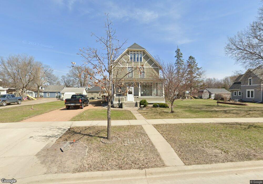
231 Adams St SE Hutchinson, MN 55350
Estimated Value: $263,000 - $269,000
3
Beds
2
Baths
2,009
Sq Ft
$132/Sq Ft
Est. Value
About This Home
This home is located at 231 Adams St SE, Hutchinson, MN 55350 and is currently estimated at $265,819, approximately $132 per square foot. 231 Adams St SE is a home located in McLeod County with nearby schools including Hutchinson West Elementary School, Hutchinson Park Elementary School, and Hutchinson Middle School.
Ownership History
Date
Name
Owned For
Owner Type
Purchase Details
Closed on
Aug 27, 2018
Sold by
Brinkman Duane H and Brinkman Donna J
Bought by
Thorne Joseph Michael and Conlin Jessica
Current Estimated Value
Home Financials for this Owner
Home Financials are based on the most recent Mortgage that was taken out on this home.
Original Mortgage
$186,459
Outstanding Balance
$164,379
Interest Rate
5.12%
Mortgage Type
FHA
Estimated Equity
$101,440
Create a Home Valuation Report for This Property
The Home Valuation Report is an in-depth analysis detailing your home's value as well as a comparison with similar homes in the area
Home Values in the Area
Average Home Value in this Area
Purchase History
| Date | Buyer | Sale Price | Title Company |
|---|---|---|---|
| Thorne Joseph Michael | $189,900 | Results Title |
Source: Public Records
Mortgage History
| Date | Status | Borrower | Loan Amount |
|---|---|---|---|
| Open | Thorne Joseph Michael | $186,459 |
Source: Public Records
Tax History Compared to Growth
Tax History
| Year | Tax Paid | Tax Assessment Tax Assessment Total Assessment is a certain percentage of the fair market value that is determined by local assessors to be the total taxable value of land and additions on the property. | Land | Improvement |
|---|---|---|---|---|
| 2024 | $3,190 | $242,700 | $58,400 | $184,300 |
| 2023 | $3,180 | $235,100 | $58,400 | $176,700 |
| 2022 | $2,866 | $224,800 | $55,400 | $169,400 |
| 2021 | $2,666 | $188,300 | $48,500 | $139,800 |
| 2020 | $2,608 | $169,600 | $44,100 | $125,500 |
| 2019 | $2,452 | $162,500 | $44,100 | $118,400 |
| 2018 | $2,332 | $0 | $0 | $0 |
| 2017 | $1,926 | $0 | $0 | $0 |
| 2016 | $1,828 | $0 | $0 | $0 |
| 2015 | $1,644 | $0 | $0 | $0 |
| 2014 | -- | $0 | $0 | $0 |
Source: Public Records
Map
Nearby Homes
- 315 Adams St SE
- 205 Adams St SE
- 426 Monroe St SE
- 135 4th Ave SE
- 436 Adams St SE
- 533 Huron St SE
- 207 4th Ave NE
- 569 Glen St SW
- 310 & 312 4th Ave SW
- 726 Ivy Ln SE
- 616 Brown St SW
- 230 Lynn Rd SW
- 126 Lynn Rd SW
- 525 Bluff St NE
- 524 Bluff St NE
- 570 Lynn Rd SW
- 530 Lincoln Ave SW
- 545 4th Ave SW
- 321 Highway 7 E
- 1025 5th Ave SE
- 215 Adams St SE
- 215 215 Adams St SE
- 243 Adams St SE
- 226 Monroe St SE
- 226 Monroe St SE
- 236 Monroe St SE
- 236 236 Monroe-Street-se
- 216 Monroe St SE
- 216 216 Monroe St SE
- 206 Monroe St SE
- 246 Monroe St SE
- 206 Monroe St SE
- 226 Adams St SE
- 236 Adams St SE
- 216 216 Adams-Street-se
- 216 216 Adams St SE
- 216 Adams St SE
- 204 Adams St SE
- 305 Adams St SE
- 206 206 Monroe St SE