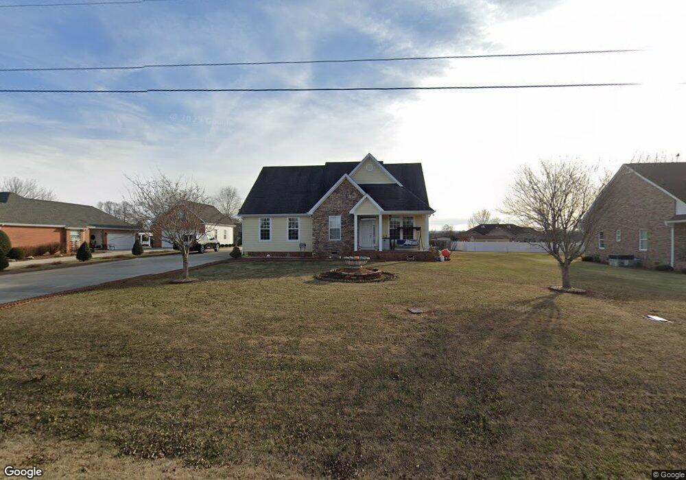
231 Brandi Cir Winchester, TN 37398
Estimated Value: $480,619 - $502,000
--
Bed
3
Baths
2,326
Sq Ft
$212/Sq Ft
Est. Value
About This Home
This home is located at 231 Brandi Cir, Winchester, TN 37398 and is currently estimated at $492,155, approximately $211 per square foot. 231 Brandi Cir is a home located in Franklin County with nearby schools including North Middle School, Franklin County High School, and Winchester Christian Academy.
Ownership History
Date
Name
Owned For
Owner Type
Purchase Details
Closed on
Aug 16, 2019
Sold by
Patel Suman Kumar and Patel Aruna Ben
Bought by
Patel Pooja S
Current Estimated Value
Purchase Details
Closed on
Jul 16, 2007
Sold by
Henley Bobby R
Bought by
Patel Suman Kumar
Purchase Details
Closed on
May 12, 2006
Sold by
Scott Nancy M
Bought by
Henley Bobby R
Purchase Details
Closed on
Oct 18, 1991
Bought by
Scott Nancy M
Create a Home Valuation Report for This Property
The Home Valuation Report is an in-depth analysis detailing your home's value as well as a comparison with similar homes in the area
Home Values in the Area
Average Home Value in this Area
Purchase History
| Date | Buyer | Sale Price | Title Company |
|---|---|---|---|
| Patel Pooja S | -- | None Available | |
| Patel Suman Kumar | $21,300 | -- | |
| Henley Bobby R | $25,000 | -- | |
| Scott Nancy M | $7,500 | -- |
Source: Public Records
Tax History Compared to Growth
Tax History
| Year | Tax Paid | Tax Assessment Tax Assessment Total Assessment is a certain percentage of the fair market value that is determined by local assessors to be the total taxable value of land and additions on the property. | Land | Improvement |
|---|---|---|---|---|
| 2024 | $0 | $98,375 | $11,250 | $87,125 |
| 2023 | $2,530 | $98,375 | $11,250 | $87,125 |
| 2022 | $2,480 | $98,375 | $11,250 | $87,125 |
| 2021 | $1,641 | $98,375 | $11,250 | $87,125 |
| 2020 | $1,830 | $64,075 | $5,525 | $58,550 |
| 2019 | $1,830 | $51,775 | $5,525 | $46,250 |
| 2018 | $1,724 | $51,775 | $5,525 | $46,250 |
| 2017 | $1,724 | $51,775 | $5,525 | $46,250 |
| 2016 | $1,594 | $47,875 | $5,025 | $42,850 |
| 2015 | $1,565 | $47,875 | $5,025 | $42,850 |
| 2014 | $1,565 | $47,891 | $0 | $0 |
Source: Public Records
Map
Nearby Homes
- 0 Spring Hill Dr
- 1108 N Jefferson St
- 60 Sharp Cir
- 111 Barefoot Way
- 124 Barefoot Way
- 114 11th Ave NW
- 136 Bel Aire Dr
- 74 Summerlake Ct
- 0 Summerlake Ct Unit RTC2936678
- 0 Summerlake Ct Unit RTC2936679
- 0 Summerlake Ct Unit RTC2936676
- 0 Summerlake Ct Unit RTC2936675
- 0 Summerlake Ct Unit RTC2936677
- 0 Summerlake Ct Unit RTC2936673
- 0 Summerlake Ct Unit RTC2936674
- 103 Lisa Cir
- 67 Summerset Dr
- 0 Sharp Springs Rd Unit RTC2980057
- 53 Summerset Dr
- 906 N High St