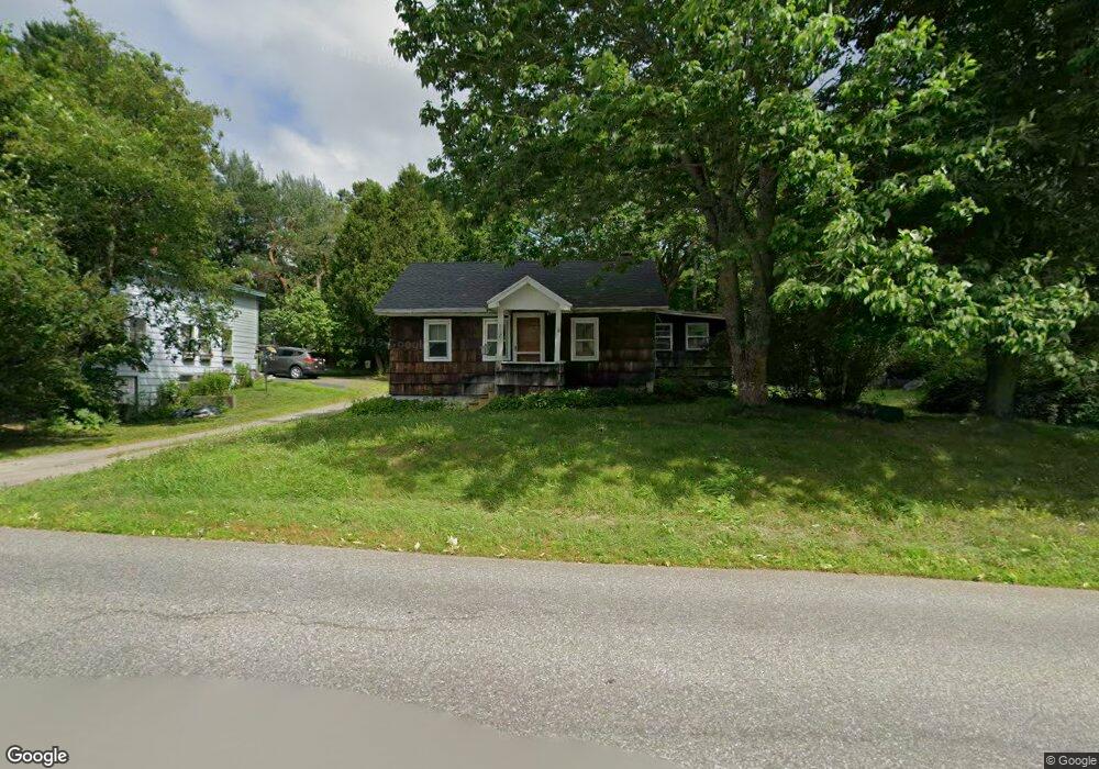
231 Cony Rd Augusta, ME 04330
Estimated Value: $153,951 - $263,000
1
Bed
1
Bath
1,030
Sq Ft
$222/Sq Ft
Est. Value
About This Home
This home is located at 231 Cony Rd, Augusta, ME 04330 and is currently estimated at $228,488, approximately $221 per square foot. 231 Cony Rd is a home located in Kennebec County with nearby schools including Cony Middle School, Cony School, and Maine Virtual Academy.
Ownership History
Date
Name
Owned For
Owner Type
Purchase Details
Closed on
Apr 29, 2008
Sold by
Ameriquest Mtg Securities and Deutsche Bank Na
Bought by
Meader Jodi
Current Estimated Value
Home Financials for this Owner
Home Financials are based on the most recent Mortgage that was taken out on this home.
Original Mortgage
$70,380
Outstanding Balance
$34,983
Interest Rate
6.22%
Mortgage Type
Purchase Money Mortgage
Estimated Equity
$193,505
Purchase Details
Closed on
Jul 3, 2007
Sold by
Ameriquest Mtg Securities and Deutsche Bk Natl T Co
Bought by
Deutsche Bk Natl T Co and Ameriquest Mtg Securities
Create a Home Valuation Report for This Property
The Home Valuation Report is an in-depth analysis detailing your home's value as well as a comparison with similar homes in the area
Home Values in the Area
Average Home Value in this Area
Purchase History
| Date | Buyer | Sale Price | Title Company |
|---|---|---|---|
| Meader Jodi | -- | -- | |
| Meader Jodi | -- | -- | |
| Meader Jodi | -- | -- | |
| Deutsche Bk Natl T Co | -- | -- | |
| Deutsche Bk Natl T Co | -- | -- |
Source: Public Records
Mortgage History
| Date | Status | Borrower | Loan Amount |
|---|---|---|---|
| Open | Deutsche Bk Natl T Co | $70,380 | |
| Closed | Deutsche Bk Natl T Co | $70,380 |
Source: Public Records
Tax History
| Year | Tax Paid | Tax Assessment Tax Assessment Total Assessment is a certain percentage of the fair market value that is determined by local assessors to be the total taxable value of land and additions on the property. | Land | Improvement |
|---|---|---|---|---|
| 2024 | $1,628 | $68,400 | $29,700 | $38,700 |
| 2023 | $1,570 | $68,400 | $29,700 | $38,700 |
| 2022 | $1,499 | $68,400 | $29,700 | $38,700 |
| 2021 | $1,432 | $68,400 | $29,700 | $38,700 |
| 2020 | $1,432 | $68,400 | $29,700 | $38,700 |
| 2019 | $1,434 | $68,400 | $29,700 | $38,700 |
| 2018 | $1,434 | $68,400 | $29,700 | $38,700 |
| 2017 | $1,394 | $68,400 | $29,700 | $38,700 |
| 2016 | $1,354 | $68,400 | $29,700 | $38,700 |
| 2015 | $1,327 | $68,400 | $29,700 | $38,700 |
| 2014 | $1,277 | $68,400 | $29,700 | $38,700 |
Source: Public Records
Map
Nearby Homes
- Lot 17 Cony Rd
- 27 Village Cir Unit 1
- 29 Village Cir Unit 1
- 18 Abenaki Rd
- 84 Windsor Ave
- 11 Pleasant Hill Rd
- 112 Fieldstone Dr
- 105 Fieldstone Dr
- 10 Penley St
- 116 Fieldstone Dr
- 78 Fieldstone Dr
- 122 Pierce Dr
- 1 Sherbrook St
- 95 Eastern Ave
- 15 Fieldstone Dr
- 11 Kennison St
- 47 Congress St
- Lot 254 Eastern Ave
- 166 Leavitt Rd
- 35 E Chestnut St
Your Personal Tour Guide
Ask me questions while you tour the home.