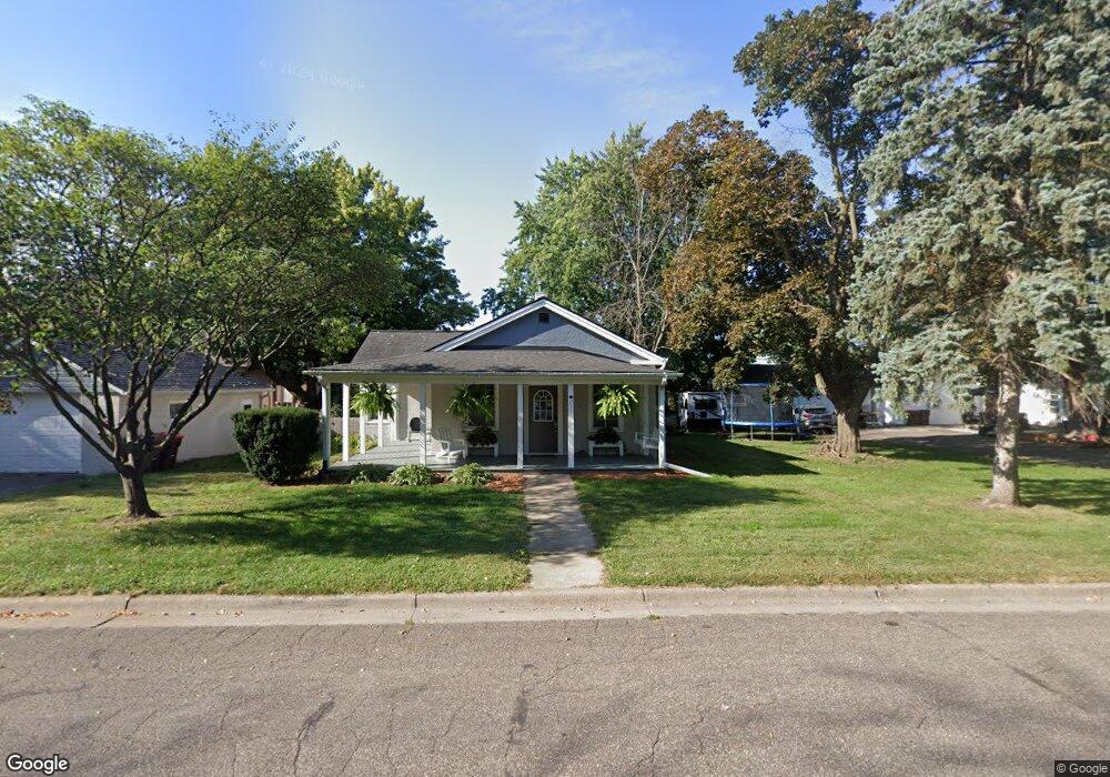
231 Elm St N Prescott, WI 54021
Estimated Value: $233,396 - $282,000
2
Beds
2
Baths
1,288
Sq Ft
$197/Sq Ft
Est. Value
About This Home
This home is located at 231 Elm St N, Prescott, WI 54021 and is currently estimated at $254,099, approximately $197 per square foot. 231 Elm St N is a home located in Pierce County with nearby schools including Malone Elementary School, Prescott Middle School, and Prescott High School.
Ownership History
Date
Name
Owned For
Owner Type
Purchase Details
Closed on
Jan 3, 2025
Sold by
Larson Michael P
Bought by
Shanley Andrew
Current Estimated Value
Purchase Details
Closed on
Jan 25, 2022
Sold by
Bronk Matthew S
Bought by
Larson Michael P
Purchase Details
Closed on
Sep 10, 2021
Sold by
Henderson Amil J and Henderson Carla E
Bought by
Bronk Matthew S and Hovel Allison R
Create a Home Valuation Report for This Property
The Home Valuation Report is an in-depth analysis detailing your home's value as well as a comparison with similar homes in the area
Home Values in the Area
Average Home Value in this Area
Purchase History
| Date | Buyer | Sale Price | Title Company |
|---|---|---|---|
| Shanley Andrew | $285,000 | Kim Metzgar | |
| Larson Michael P | $215,000 | Pierce County Abstract And Tit | |
| Bronk Matthew S | $180,000 | Edina Realty Title |
Source: Public Records
Tax History Compared to Growth
Tax History
| Year | Tax Paid | Tax Assessment Tax Assessment Total Assessment is a certain percentage of the fair market value that is determined by local assessors to be the total taxable value of land and additions on the property. | Land | Improvement |
|---|---|---|---|---|
| 2024 | $3,800 | $215,000 | $45,800 | $169,200 |
| 2023 | $3,682 | $215,000 | $45,800 | $169,200 |
| 2022 | $2,865 | $119,600 | $26,200 | $93,400 |
| 2021 | $2,825 | $119,600 | $26,200 | $93,400 |
| 2020 | $3,275 | $119,600 | $26,200 | $93,400 |
| 2019 | $3,791 | $119,600 | $26,200 | $93,400 |
| 2018 | $3,713 | $119,600 | $26,200 | $93,400 |
| 2017 | $4,194 | $119,600 | $26,200 | $93,400 |
| 2016 | $3,799 | $109,400 | $26,200 | $83,200 |
| 2015 | $2,745 | $109,400 | $26,200 | $83,200 |
| 2014 | $2,644 | $109,400 | $26,200 | $83,200 |
| 2013 | $2,494 | $109,400 | $26,200 | $83,200 |
Source: Public Records
Map
Nearby Homes
- 316 Young St N
- 284 Elm St S
- 150 Front St N Unit 421
- 150 Front St N Unit 323
- 368 Young St S
- 728 Linn St
- 568 Locust St S
- 170 Tower Rd
- XXX Locust St
- 155 Linden Rd
- 1433 Glenridge Dr
- 170 Mississippi St
- 833 River Terrace
- 1813 Canton Rd
- 565 Pleasant Dr
- 580 Northern Lights Dr
- 482 Delta Queen Ave
- Virginia Plan at Great Rivers
- Tennessee Plan at Great Rivers
- Vermont Plan at Great Rivers