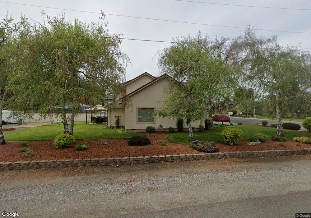
2313 Tulane Ave Central Point, OR 97502
Estimated Value: $573,495 - $598,000
3
Beds
3
Baths
2,231
Sq Ft
$262/Sq Ft
Est. Value
About This Home
This home is located at 2313 Tulane Ave, Central Point, OR 97502 and is currently estimated at $585,498, approximately $262 per square foot. 2313 Tulane Ave is a home located in Jackson County with nearby schools including Richardson Elementary School, Scenic Middle School, and Crater High School.
Ownership History
Date
Name
Owned For
Owner Type
Purchase Details
Closed on
Mar 8, 2006
Sold by
Crume Corp
Bought by
Sills Larry R
Current Estimated Value
Purchase Details
Closed on
Nov 22, 2004
Sold by
Crume Corp
Bought by
Sills Larry R and Sills Sharon K
Create a Home Valuation Report for This Property
The Home Valuation Report is an in-depth analysis detailing your home's value as well as a comparison with similar homes in the area
Home Values in the Area
Average Home Value in this Area
Purchase History
| Date | Buyer | Sale Price | Title Company |
|---|---|---|---|
| Sills Larry R | $100,000 | Accommodation | |
| Sills Larry R | -- | -- |
Source: Public Records
Tax History Compared to Growth
Tax History
| Year | Tax Paid | Tax Assessment Tax Assessment Total Assessment is a certain percentage of the fair market value that is determined by local assessors to be the total taxable value of land and additions on the property. | Land | Improvement |
|---|---|---|---|---|
| 2025 | $4,472 | $363,960 | $92,760 | $271,200 |
| 2024 | $4,472 | $353,360 | $79,320 | $274,040 |
| 2023 | $4,323 | $343,070 | $77,020 | $266,050 |
| 2022 | $4,231 | $343,070 | $77,020 | $266,050 |
| 2021 | $4,111 | $333,080 | $74,770 | $258,310 |
| 2020 | $3,991 | $323,380 | $72,590 | $250,790 |
| 2019 | $3,899 | $304,830 | $68,430 | $236,400 |
| 2018 | $3,778 | $295,960 | $66,430 | $229,530 |
| 2017 | $3,688 | $295,960 | $66,430 | $229,530 |
| 2016 | $3,580 | $278,980 | $62,610 | $216,370 |
| 2015 | $3,414 | $278,980 | $62,610 | $216,370 |
| 2014 | $3,332 | $262,980 | $59,010 | $203,970 |
Source: Public Records
Map
Nearby Homes
- 407 Silver Creek Dr
- 1134 Steamboat Dr
- 1135 Shake Dr
- 626 Griffin Oaks Dr
- 1159 Rustler Peak St
- 619 Palo Verde Way
- 0 Boulder Ridge St
- 1167 Boulder Ridge St
- 526 Stone Pointe Dr
- 420 Mayberry Ln
- 629 Bridge Creek Dr
- 1317 River Run St
- 429 Mayberry Ln
- 905 Comet Ave
- 25 Donna Way
- 426 Bridge Creek Dr
- 3642 Oak Pine Way
- 4626 N Pacific Hwy
- 327 Brookhaven Dr
- 570 Bachand Cir
- 2315 Tulane Ave
- 4123 Sunland Ave
- 4146 Sunland Ave
- 2312 Tulane Ave
- 4166 Sunland Ave
- 4124 Sunland Ave
- 4170 Sunland Ave
- 2361 Tulane Ave
- 2350 Tulane Ave
- 4103 Sunland Ave
- 4108 Sunland Ave
- 2360 Tulane Ave
- 4174 Sunland Ave
- 4080 Carlton Ave
- 4100 Carlton Ave
- 4178 Sunland Ave
- 1001 Steamboat Dr
- 663 Silver Creek Dr
- 1005 Steamboat Dr
- 671 Silver Creek Dr