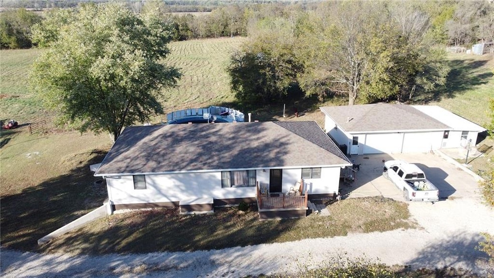


2317 Maple Rd Fort Scott, KS 66701
Estimated payment $2,238/month
Highlights
- Above Ground Pool
- Deck
- No HOA
- 522,720 Sq Ft lot
- Ranch Style House
- Formal Dining Room
About This Home
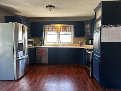
Discover the perfect blend of country living and modern comfort on this sprawling 12-acre property, ideally located off blacktop just outside city limits in a quiet, peaceful neighborhood. This spacious 6-bedroom, 3-bathroom home offers approximately 1,650 sq ft on the main level, along with an additional 1,650 sq ft in the fully finished basement, providing plenty of space for family, guests, hobbies, or a growing homestead lifestyle. The inviting floor plan supports comfortable daily living, while the large back deck and above-ground pool create the perfect setting for entertaining or unwinding at the end of the day. The land is fully fenced and ready for livestock, complete with a corral, chute, and automatic waterer already in place. A large detached two-car garage offers extra workspace or storage, and additional outbuildings provide flexibility for equipment, animals, or farm projects. Whether you’re raising cattle, working in the shop, or enjoying a sunset from the deck, this property is set up to support the rural lifestyle you’ve been dreaming of. Recreational opportunities abound, with a proven history of large deer harvested on the property. Whether you’d like to hunt from your back door or simply enjoy the privacy of wide-open space, this land offers endless possibilities.
Listing Agent
Trophy Properties & Auction Brokerage Phone: 620-224-6003 License #00231611 Listed on: 10/24/2025

Co-Listing Agent
Trophy Properties & Auction Brokerage Phone: 620-224-6003 License #00250423
Home Details
Home Type
- Single Family
Est. Annual Taxes
- $3,247
Year Built
- Built in 1979
Lot Details
- 12 Acre Lot
Parking
- 2 Car Detached Garage
Home Design
- Ranch Style House
- Traditional Architecture
- Frame Construction
- Composition Roof
Interior Spaces
- Formal Dining Room
- Finished Basement
- Basement Fills Entire Space Under The House
- Laundry on main level
Bedrooms and Bathrooms
- 6 Bedrooms
Outdoor Features
- Above Ground Pool
- Deck
Utilities
- Central Air
- Heating System Uses Natural Gas
- Septic Tank
Community Details
- No Home Owners Association
Listing and Financial Details
- Assessor Parcel Number 114-20-0-40-00-005.00-0
- $0 special tax assessment
Map
Home Values in the Area
Average Home Value in this Area
Tax History
| Year | Tax Paid | Tax Assessment Tax Assessment Total Assessment is a certain percentage of the fair market value that is determined by local assessors to be the total taxable value of land and additions on the property. | Land | Improvement |
|---|---|---|---|---|
| 2025 | -- | $23,347 | $1,157 | $22,190 |
| 2024 | $3,246 | $22,273 | $1,151 | $21,122 |
| 2023 | $3,049 | $20,439 | $1,154 | $19,285 |
| 2022 | $2,897 | $19,550 | $1,142 | $18,408 |
| 2021 | $2,870 | $18,305 | $1,130 | $17,175 |
| 2020 | $2,843 | $18,044 | $1,124 | $16,920 |
| 2019 | $2,116 | $13,354 | $1,103 | $12,251 |
| 2018 | $2,203 | $13,902 | $1,085 | $12,817 |
| 2017 | $2,217 | $13,869 | $1,058 | $12,811 |
| 2016 | -- | $13,340 | $1,017 | $12,323 |
| 2015 | -- | $12,405 | $892 | $11,513 |
| 2014 | -- | $12,266 | $868 | $11,398 |
Property History
| Date | Event | Price | List to Sale | Price per Sq Ft |
|---|---|---|---|---|
| 11/12/2025 11/12/25 | Price Changed | $372,500 | -2.0% | $113 / Sq Ft |
| 10/24/2025 10/24/25 | For Sale | $380,000 | -- | $115 / Sq Ft |
Purchase History
| Date | Type | Sale Price | Title Company |
|---|---|---|---|
| Grant Deed | $117,437 | -- |
Mortgage History
| Date | Status | Loan Amount | Loan Type |
|---|---|---|---|
| Open | $116,275 | FHA |
Source: Heartland MLS
MLS Number: 2583824
APN: 114-20-0-40-00-005.00-0
Disclaimer: Certain information contained herein is derived from information provided by parties other than Homes.com. All information provided is deemed reliable, but is not guaranteed to be accurate and should be independently verified.
![]() Based on information submitted to the MLS GRID as of [see last changed date above]. All data is obtained from various sources and may not have been verified by broker or MLS GRID. Supplied Open House Information is subject to change without notice. All information should be independently reviewed and verified for accuracy. Properties may or may not be listed by the office/agent presenting the information. Some IDX listings have been excluded from this website. Prices displayed on all Sold listings are the Last Known Listing Price and may not be the actual selling price.
Based on information submitted to the MLS GRID as of [see last changed date above]. All data is obtained from various sources and may not have been verified by broker or MLS GRID. Supplied Open House Information is subject to change without notice. All information should be independently reviewed and verified for accuracy. Properties may or may not be listed by the office/agent presenting the information. Some IDX listings have been excluded from this website. Prices displayed on all Sold listings are the Last Known Listing Price and may not be the actual selling price.
Listing Information presented by local MLS brokerage: TEN-X, INC., local REALTOR®- Arlene Richardson - (888)952-6393
The Digital Millennium Copyright Act of 1998, 17 U.S.C. § 512 (the “DMCA”) provides recourse for copyright owners who believe that material appearing on the Internet infringes their rights under U.S. copyright law. If you believe in good faith that any content or material made available in connection with our website or services infringes your copyright, you (or your agent) may send us a notice requesting that the content or material be removed, or access to it blocked.
Notices must be sent in writing by email to DMCAnotice@MLSGrid.com.
The DMCA requires that your notice of alleged copyright infringement include the following information:
(1) description of the copyrighted work that is the subject of claimed infringement;
(2) description of the alleged infringing content and information sufficient to permit us to locate the content;
(3) contact information for you, including your address, telephone number and email address;
(4) a statement by you that you have a good faith belief that the content in the manner complained of is not authorized by the copyright owner, or its agent, or by the operation of any law;
(5) a statement by you, signed under penalty of perjury, that the information in the notification is accurate and that you have the authority to enforce the copyrights that are claimed to be infringed; and
(6) a physical or electronic signature of the copyright owner or a person authorized to act on the copyright owner’s behalf. Failure to include all of the above information may result in the delay of the processing of your complaint.
- 1828 E Pine St
- 1804 E Oak St
- 1629 E Oak St
- 124 N Grant St
- 1308 240th St
- 1233 235th St
- 407 S Broadway St
- 709 E 1st St
- 223 S Hill St
- 622 S Little St
- 0 S Madison St Unit HMS2558732
- 1213 240th St
- 108 N Crawford St
- 912 S Margrave St
- 20 S Crawford St
- 12 S Eddy St
- 523 S Judson St
- 710 S Main St
- 109 S Holbrook St
- 523 S Crawford St