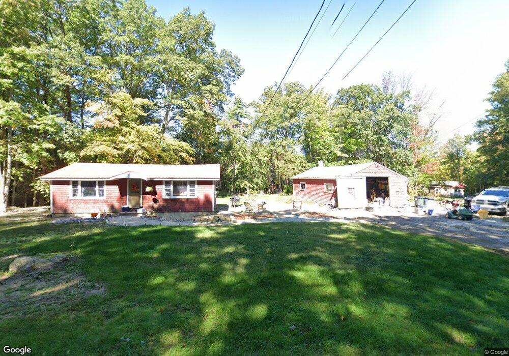
232 Carley Rd Peterborough, NH 03458
Estimated Value: $947,000 - $1,234,000
2
Beds
2
Baths
3,472
Sq Ft
$306/Sq Ft
Est. Value
About This Home
This home is located at 232 Carley Rd, Peterborough, NH 03458 and is currently estimated at $1,063,354, approximately $306 per square foot. 232 Carley Rd is a home located in Hillsborough County with nearby schools including Peterborough Elementary School, South Meadow School, and Conval Regional High School.
Ownership History
Date
Name
Owned For
Owner Type
Purchase Details
Closed on
Oct 25, 2023
Sold by
Mcgill Michael A and Mcgill Robin C
Bought by
Mcgill Ft and Mcgill
Current Estimated Value
Purchase Details
Closed on
Dec 1, 2020
Sold by
Brown Randy I and Marshall Lance E
Bought by
Mcgill Michael A and Mcgill Robin M
Home Financials for this Owner
Home Financials are based on the most recent Mortgage that was taken out on this home.
Original Mortgage
$510,400
Interest Rate
2.8%
Mortgage Type
Purchase Money Mortgage
Create a Home Valuation Report for This Property
The Home Valuation Report is an in-depth analysis detailing your home's value as well as a comparison with similar homes in the area
Home Values in the Area
Average Home Value in this Area
Purchase History
| Date | Buyer | Sale Price | Title Company |
|---|---|---|---|
| Mcgill Ft | -- | None Available | |
| Mcgill Michael A | $642,533 | None Available |
Source: Public Records
Mortgage History
| Date | Status | Borrower | Loan Amount |
|---|---|---|---|
| Previous Owner | Mcgill Michael A | $510,400 |
Source: Public Records
Tax History Compared to Growth
Tax History
| Year | Tax Paid | Tax Assessment Tax Assessment Total Assessment is a certain percentage of the fair market value that is determined by local assessors to be the total taxable value of land and additions on the property. | Land | Improvement |
|---|---|---|---|---|
| 2024 | $24,209 | $744,880 | $97,980 | $646,900 |
| 2023 | $20,998 | $744,880 | $97,980 | $646,900 |
| 2022 | $14,553 | $562,780 | $97,980 | $464,800 |
| 2021 | $14,497 | $562,780 | $97,980 | $464,800 |
| 2020 | $14,900 | $483,130 | $79,030 | $404,100 |
| 2019 | $14,373 | $483,130 | $79,030 | $404,100 |
| 2018 | $14,537 | $483,130 | $79,030 | $404,100 |
| 2017 | $13,296 | $422,630 | $76,030 | $346,600 |
| 2016 | $13,034 | $422,630 | $76,030 | $346,600 |
| 2015 | $12,556 | $422,630 | $76,030 | $346,600 |
| 2014 | $12,348 | $404,070 | $79,270 | $324,800 |
Source: Public Records
Map
Nearby Homes
- 248 Carley Rd
- Lot 3 Carley Rd
- Lot 4 Carley Rd
- Lot 4 Carley Rd Unit 4
- 0 Carley Unit 114
- 0 Carley Unit 114 4764233
- 0 Carley Unit 113 4764228
- 0 Carley Unit 113 4667722
- 0 Carley Unit 114 4667719
- 0 Carley Unit 112 4763858
- 0 Carley Unit 112 4661598
- 0 Carley Rd Unit Map R5, Lot 10
- 110 Carley Rd Unit Lot 110
- 109 Carley Rd Unit Lot 109
- 108 Carley Rd Unit Lot 108
- 00 Carley Rd
- 0 Carley Rd Unit 4033838
- 0 Carley Rd Unit R005-011-006
- 280 Carley Rd
- 241 Carley Rd