232 Highway 92 S Dandridge, TN 37725
Estimated payment $1,571/month
Highlights
- Very Popular Property
- Wooded Lot
- Cathedral Ceiling
- 2.52 Acre Lot
- Ranch Style House
- No HOA
About This Home
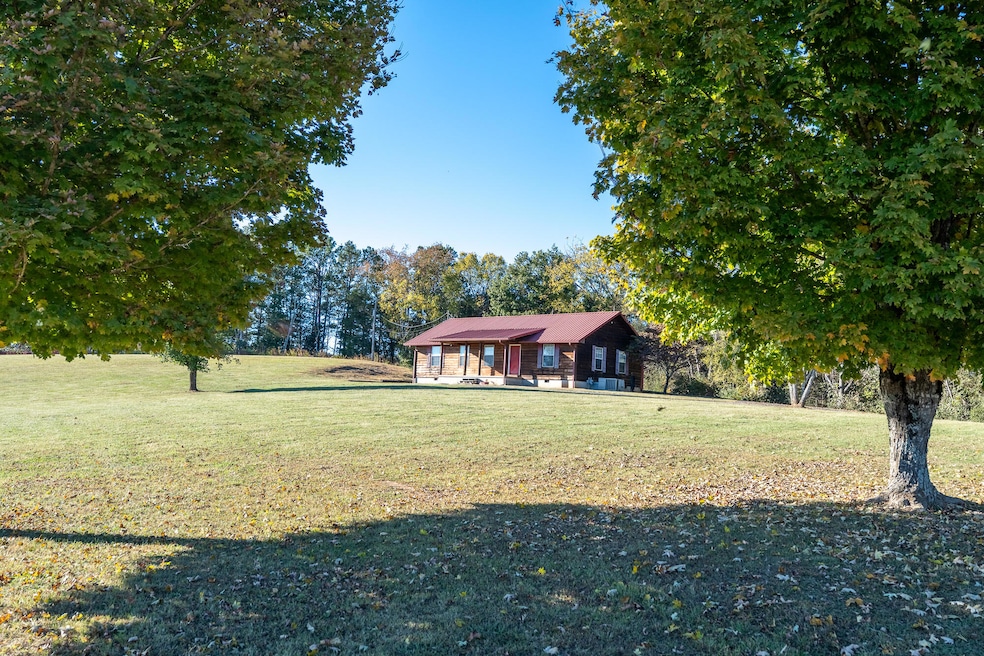
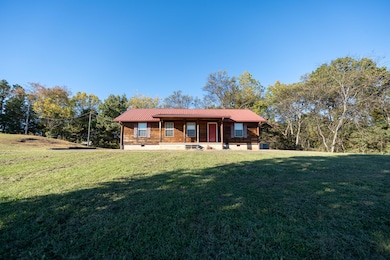
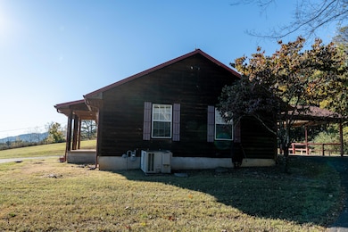
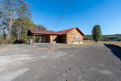
Charming Cabin-Style Home on 2.5 Acres in Dandridge!
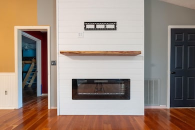
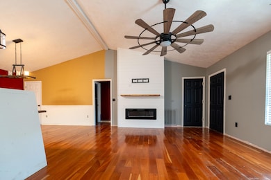
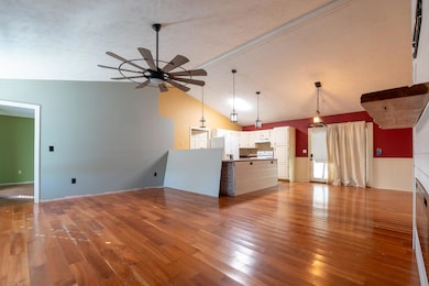
This log-cabin style home offers 3 bedrooms, 2 bathrooms, and 1,344 square feet of living space, nestled on 2.52 acres just a couple of minutes from I-40. Enjoy the convenience of quick access east or west while still having the privacy and space of a country setting. The home features an open floor plan, metal roof, and a drive-through carport with circular driveway access around the house. Most of the acreage lies behind the home and is wooded and steep, providing a natural, private backdrop. Home is being sold AS IS and does need repairs, updates, and cosmetic improvements — the perfect opportunity for someone looking to add their own touch or invest in a property with great potential in a highly convenient location.
Home Details
Home Type
- Single Family
Est. Annual Taxes
- $1,547
Year Built
- Built in 1991
Lot Details
- 2.52 Acre Lot
- Property fronts a highway
- Gentle Sloping Lot
- Cleared Lot
- Wooded Lot
Parking
- 1 Carport Space
Home Design
- Ranch Style House
- Log Cabin
- Fixer Upper
- Block Foundation
- Wood Siding
Interior Spaces
- 1,344 Sq Ft Home
- Cathedral Ceiling
- Ceiling Fan
- Metal Fireplace
- Electric Fireplace
- Blinds
- Window Screens
- Storage
Kitchen
- Electric Range
- Laminate Countertops
- Disposal
Flooring
- Carpet
- Luxury Vinyl Tile
Bedrooms and Bathrooms
- 3 Bedrooms
- Walk-In Closet
- 2 Full Bathrooms
Laundry
- Laundry Room
- Laundry on main level
- Washer
- Sink Near Laundry
Schools
- Mt. Horeb Elementary School
- Maury Middle School
- Jefferson High School
Utilities
- Central Air
- Heat Pump System
- Heating System Uses Natural Gas
- Natural Gas Connected
- Electric Water Heater
- Septic Tank
- High Speed Internet
- Cable TV Available
Additional Features
- Covered Patio or Porch
- City Lot
Community Details
- No Home Owners Association
Listing and Financial Details
- Assessor Parcel Number 056.07
Map
Home Values in the Area
Average Home Value in this Area
Tax History
| Year | Tax Paid | Tax Assessment Tax Assessment Total Assessment is a certain percentage of the fair market value that is determined by local assessors to be the total taxable value of land and additions on the property. | Land | Improvement |
|---|---|---|---|---|
| 2025 | $1,296 | $76,900 | $25,150 | $51,750 |
| 2023 | $1,296 | $40,450 | $0 | $0 |
| 2022 | $1,252 | $40,450 | $12,525 | $27,925 |
| 2021 | $1,252 | $40,450 | $12,525 | $27,925 |
| 2020 | $1,254 | $40,450 | $12,525 | $27,925 |
| 2019 | $1,256 | $40,450 | $12,525 | $27,925 |
| 2018 | $1,270 | $37,900 | $13,300 | $24,600 |
| 2017 | $1,270 | $37,900 | $13,300 | $24,600 |
| 2016 | $1,270 | $37,900 | $13,300 | $24,600 |
| 2015 | $1,269 | $37,900 | $13,300 | $24,600 |
| 2014 | $1,265 | $37,900 | $13,300 | $24,600 |
Property History
| Date | Event | Price | List to Sale | Price per Sq Ft |
|---|---|---|---|---|
| 12/06/2025 12/06/25 | For Sale | $275,000 | 0.0% | $205 / Sq Ft |
| 10/24/2025 10/24/25 | Pending | -- | -- | -- |
| 10/15/2025 10/15/25 | For Sale | $275,000 | -- | $205 / Sq Ft |
Purchase History
| Date | Type | Sale Price | Title Company |
|---|---|---|---|
| Quit Claim Deed | -- | -- | |
| Deed | $36,000 | -- | |
| Warranty Deed | $78,000 | -- | |
| Warranty Deed | $5,000 | -- |
Source: Lakeway Area Association of REALTORS®
MLS Number: 709342
APN: 057-056.07
Disclaimer: Certain information contained herein is derived from information provided by parties other than Homes.com. All information provided is deemed reliable, but is not guaranteed to be accurate and should be independently verified.
![]() IDX information is provided exclusively for personal, non-commercial use, and may not be used for any purpose other than to identify prospective properties consumers may be interested in purchasing. Information is deemed reliable but not guaranteed.
IDX information is provided exclusively for personal, non-commercial use, and may not be used for any purpose other than to identify prospective properties consumers may be interested in purchasing. Information is deemed reliable but not guaranteed.
- Aria Plan at Creekside Ridge
- Cabral Plan at Creekside Ridge
- Salem Plan at Creekside Ridge
- Hayden Plan at Creekside Ridge
- Belhaven Plan at Creekside Ridge
- Cali Plan at Creekside Ridge
- Penwell Plan at Creekside Ridge
- Freeport Plan at Creekside Ridge
- Sullivan Plan at Creekside Ridge
- 6223 Sycamore Stream Rd
- 6199 Sycamore Stream Rd
- 0 66 48 Acres Milldale Rd
- Trct 5R-2 Milldale Rd
- 5R-2 Milldale Rd
- 6247 Sycamore Stream Rd
- 6239 Sycamore Stream Rd
- 1036 Patriots Landing
- 6215 Sycamore Stream Rd
- 6207 Sycamore Stream Rd
- 4026 Wesoga Dr
- 150 W Dumplin Valley Rd
- 133 James Way
- 1208 Gay St Unit C
- 1202 Deer Ln Unit 1202 -No pets allowed
- 305 Aspen Dr
- 228 Newman Cir
- 814 Carson St
- 810 Carson St Unit ID1331737P
- 930-940 E Ellis St
- 706 Jay St Unit 32
- 706 Jay St Unit 31
- 1835 River Rd
- 1308 Fredrick Ln Unit ID1266883P
- 1310 Fredrick Ln Unit ID1266885P
- 5055 Cottonseed Way
- 168 Bass Pro Dr
- 132 Burkhardt Way
- 3458 Tyee Crossing Way
- 117 Lee Greenwood Way
- 365 W Dumplin Valley Rd
