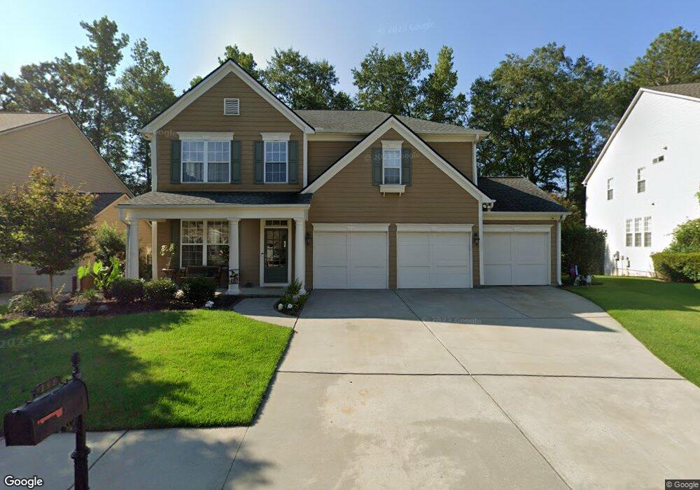
232 Independence Ln Peachtree City, GA 30269
Estimated Value: $591,051 - $665,000
--
Bed
1
Bath
2,796
Sq Ft
$227/Sq Ft
Est. Value
About This Home
This home is located at 232 Independence Ln, Peachtree City, GA 30269 and is currently estimated at $634,013, approximately $226 per square foot. 232 Independence Ln is a home located in Fayette County with nearby schools including Peachtree City Elementary School, Booth Middle School, and McIntosh High School.
Ownership History
Date
Name
Owned For
Owner Type
Purchase Details
Closed on
May 20, 2004
Sold by
Hms John Wieland
Bought by
Baccarny Robert V and Baccarny Anna
Current Estimated Value
Home Financials for this Owner
Home Financials are based on the most recent Mortgage that was taken out on this home.
Original Mortgage
$26,000
Outstanding Balance
$12,786
Interest Rate
6.09%
Mortgage Type
New Conventional
Estimated Equity
$621,227
Create a Home Valuation Report for This Property
The Home Valuation Report is an in-depth analysis detailing your home's value as well as a comparison with similar homes in the area
Home Values in the Area
Average Home Value in this Area
Purchase History
| Date | Buyer | Sale Price | Title Company |
|---|---|---|---|
| Baccarny Robert V | $262,500 | -- |
Source: Public Records
Mortgage History
| Date | Status | Borrower | Loan Amount |
|---|---|---|---|
| Open | Baccarny Robert V | $26,000 | |
| Open | Baccarny Robert V | $209,690 |
Source: Public Records
Tax History Compared to Growth
Tax History
| Year | Tax Paid | Tax Assessment Tax Assessment Total Assessment is a certain percentage of the fair market value that is determined by local assessors to be the total taxable value of land and additions on the property. | Land | Improvement |
|---|---|---|---|---|
| 2024 | $4,106 | $205,892 | $48,000 | $157,892 |
| 2023 | $4,496 | $198,120 | $48,000 | $150,120 |
| 2022 | $4,602 | $168,160 | $36,000 | $132,160 |
| 2021 | $4,335 | $145,880 | $36,000 | $109,880 |
| 2020 | $4,248 | $138,760 | $36,000 | $102,760 |
| 2019 | $4,318 | $139,680 | $36,000 | $103,680 |
| 2018 | $4,316 | $137,400 | $36,000 | $101,400 |
| 2017 | $4,237 | $134,040 | $32,000 | $102,040 |
| 2016 | $4,123 | $125,800 | $32,000 | $93,800 |
| 2015 | $3,647 | $109,720 | $19,000 | $90,720 |
| 2014 | $3,480 | $103,040 | $19,000 | $84,040 |
| 2013 | -- | $100,240 | $0 | $0 |
Source: Public Records
Map
Nearby Homes
- 719 Gittings Ave
- 138 Wynnmeade Pkwy
- 100 Kings Ridge Dr
- 405 Abbey Rd
- 64 Star Spangled Ln
- 147 Westberry St
- 22 Star Spangled Ln
- 169 Wynnmeade Pkwy
- 171 Wynnmeade Pkwy
- 826 Richmond Cir
- 107 S Fairfield Dr
- 111 S Fairfield Dr
- 844 Richmond Cir Unit 7
- 505 N Fairfield Dr
- 713 S Fairfield Dr
- 405 Sherrels Ford
- 101 Eadestowne Way
- 308 Bandon Way
- 105 Bandon Way
- 102 Bandon Way
- 234 Independence Ln
- 230 Independence Ln
- 236 Independence Ln
- 726 Gittings Ave
- 724 Gittings Ave
- 225 Independence Ln
- 227 Independence Ln
- 728 Gittings Ave
- 228 Independence Ln
- 720 Gittings Ave
- 229 Independence Ln
- 238 Independence Ln
- 226 Independence Ln
- 718 Gittings Ave
- 730 Gittings Ave
- 223 Independence Ln
- 503 Mount Vernon Way
- 716 Gittings Ave Unit 163
- 716 Gittings Ave
- 240 Independence Ln