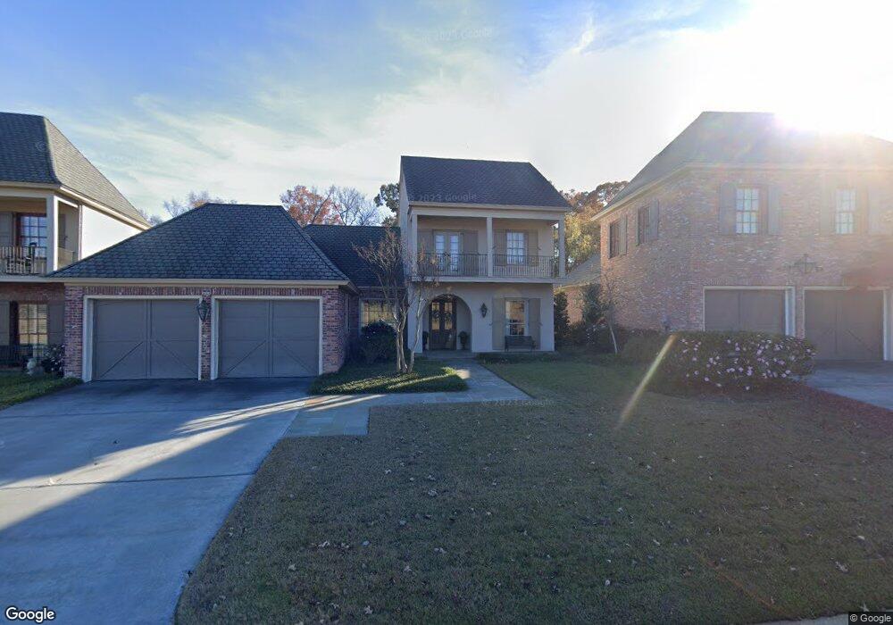
232 Keeneland Ct Choudrant, LA 71227
Estimated Value: $450,000 - $596,000
--
Bed
1
Bath
2,640
Sq Ft
$193/Sq Ft
Est. Value
About This Home
This home is located at 232 Keeneland Ct, Choudrant, LA 71227 and is currently estimated at $509,491, approximately $192 per square foot. 232 Keeneland Ct is a home located in Lincoln Parish with nearby schools including Choudrant Elementary School, Choudrant High School, and Ruston Junior High School.
Ownership History
Date
Name
Owned For
Owner Type
Purchase Details
Closed on
Sep 9, 2024
Sold by
Brolly Stephen Hugh and Kelley Himes
Bought by
Shelton Brian Christopher and Shelton Deana Kelly
Current Estimated Value
Home Financials for this Owner
Home Financials are based on the most recent Mortgage that was taken out on this home.
Original Mortgage
$486,757
Interest Rate
6.78%
Mortgage Type
Construction
Create a Home Valuation Report for This Property
The Home Valuation Report is an in-depth analysis detailing your home's value as well as a comparison with similar homes in the area
Home Values in the Area
Average Home Value in this Area
Purchase History
| Date | Buyer | Sale Price | Title Company |
|---|---|---|---|
| Shelton Brian Christopher | $477,000 | None Listed On Document |
Source: Public Records
Mortgage History
| Date | Status | Borrower | Loan Amount |
|---|---|---|---|
| Closed | Shelton Brian Christopher | $486,757 |
Source: Public Records
Tax History Compared to Growth
Tax History
| Year | Tax Paid | Tax Assessment Tax Assessment Total Assessment is a certain percentage of the fair market value that is determined by local assessors to be the total taxable value of land and additions on the property. | Land | Improvement |
|---|---|---|---|---|
| 2024 | $3,749 | $48,534 | $4,125 | $44,409 |
| 2023 | $3,480 | $43,289 | $4,125 | $39,164 |
| 2022 | $5,357 | $43,289 | $4,125 | $39,164 |
| 2021 | $4,916 | $38,395 | $4,125 | $34,270 |
| 2020 | $4,922 | $38,395 | $4,125 | $34,270 |
| 2019 | $5,058 | $39,537 | $4,125 | $35,412 |
| 2018 | $5,060 | $39,537 | $4,125 | $35,412 |
| 2017 | $5,068 | $39,537 | $4,125 | $35,412 |
| 2016 | $5,135 | $0 | $0 | $0 |
| 2015 | $5,382 | $39,371 | $3,750 | $35,621 |
| 2013 | $5,435 | $39,371 | $3,750 | $35,621 |
Source: Public Records
Map
Nearby Homes
- 134 Twin Creeks Bend
- 208 Cherrybark Way
- 448 Loblolly Ln
- 190 Loring Bend
- 178 Meadows Dr
- 1950 Louisiana 821
- 0 Spillers Rd
- 201 Vintage Ln
- 407 Highway 821
- 425 Highway 821
- 00 Cheatwood Rd
- 219 Lamar Rd
- 1074 Par Road 501
- 112 Tes Dr
- 2116 Cook Rd
- 500 Hogan Rd
- 00 Par Road 43
- 298 Wesley Dr
- 186 Deer Creek Rd
- 641 Goodgoin Rd
- 236 Keeneland Ct
- 228 Keeneland Ct
- 224 Keeneland Ct
- 240 Keeneland Ct
- 220 Keeneland Ct
- 244 Keeneland Ct
- 216 Keeneland Ct
- 248 Keeneland Ct
- 212 Keeneland Ct
- 252 Keeneland Ct
- 169 Rinehart Farms Rd
- 2073 Highway 820
- 2040 Highway 820
- 2006 Highway 820
- 205 Rinehart Farms Rd
- 2078 Highway 820
- 2104 Highway 820
- 192 Twin Creeks Bend
- 26 Loblolly Ln
- 14 Loblolly Ln