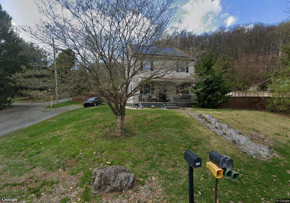
232 W Neversink Rd Reading, PA 19606
Estimated Value: $236,000 - $408,000
4
Beds
3
Baths
3,100
Sq Ft
$92/Sq Ft
Est. Value
About This Home
This home is located at 232 W Neversink Rd, Reading, PA 19606 and is currently estimated at $286,616, approximately $92 per square foot. 232 W Neversink Rd is a home located in Berks County with nearby schools including Jacksonwald Elementary School, Exeter Township Junior High School, and Exeter Township Senior High School.
Ownership History
Date
Name
Owned For
Owner Type
Purchase Details
Closed on
Feb 2, 2006
Sold by
Piersol Kristi J
Bought by
Piersol Larry K and Piersol Kristi J
Current Estimated Value
Home Financials for this Owner
Home Financials are based on the most recent Mortgage that was taken out on this home.
Original Mortgage
$106,400
Interest Rate
6.26%
Mortgage Type
New Conventional
Purchase Details
Closed on
Jan 22, 2001
Sold by
Griffith Norman W
Bought by
Griffith Norman W
Create a Home Valuation Report for This Property
The Home Valuation Report is an in-depth analysis detailing your home's value as well as a comparison with similar homes in the area
Home Values in the Area
Average Home Value in this Area
Purchase History
| Date | Buyer | Sale Price | Title Company |
|---|---|---|---|
| Piersol Larry K | -- | None Available | |
| Griffith Norman W | -- | -- |
Source: Public Records
Mortgage History
| Date | Status | Borrower | Loan Amount |
|---|---|---|---|
| Closed | Piersol Larry K | $106,400 |
Source: Public Records
Tax History
| Year | Tax Paid | Tax Assessment Tax Assessment Total Assessment is a certain percentage of the fair market value that is determined by local assessors to be the total taxable value of land and additions on the property. | Land | Improvement |
|---|---|---|---|---|
| 2025 | $1,233 | $78,800 | $35,100 | $43,700 |
| 2024 | $3,742 | $78,800 | $35,100 | $43,700 |
| 2023 | $3,620 | $78,800 | $35,100 | $43,700 |
| 2022 | $3,579 | $78,800 | $35,100 | $43,700 |
| 2021 | $3,525 | $78,800 | $35,100 | $43,700 |
| 2020 | $3,486 | $78,800 | $35,100 | $43,700 |
| 2019 | $61 | $78,800 | $35,100 | $43,700 |
| 2018 | $3,437 | $78,800 | $35,100 | $43,700 |
| 2017 | $3,388 | $78,800 | $35,100 | $43,700 |
| 2016 | $827 | $78,800 | $35,100 | $43,700 |
| 2015 | $827 | $78,800 | $35,100 | $43,700 |
| 2014 | $798 | $78,800 | $35,100 | $43,700 |
Source: Public Records
Map
Nearby Homes
- 56 Hearthstone Dr
- 67 Emily Ct
- 74 Emily Ct
- 31 Hearthstone Dr
- 21 Hearthstone Dr
- 3503 Romig Ave
- 16 W 35th St
- 6 A Alpine Ct
- 9 W 35th St
- 25 W 33rd St
- 16 E 34th St
- 2422 Highland Ave
- 3212 Perkiomen Ave
- 2446 Grandview Ave
- 2638 Fairview Ave
- 0 Perkiomen Ave Unit PABK2061892
- 92 Christine Dr
- 19 Pennwyn Terrace
- 45-8 Holly Dr
- 2531 Perkiomen Ave
- 228 W Neversink Rd
- 231 W Neversink Rd
- 67 Hearthstone Dr
- 229 W Neversink Rd
- 224 W Neversink Rd
- 227 W Neversink Rd
- 310 W Neversink Rd
- 60 Hearthstone Dr
- 1 Ironstone Dr
- 65 Hearthstone Dr
- 3 Ironstone Dr
- 225 W Neversink Rd
- 312 W Neversink Rd
- 311 W Neversink Rd
- 5 Ironstone Dr
- 6 Lori Ct
- 223 W Neversink Rd
- 313 W Neversink Rd
- 7 Ironstone Dr
- 5 Lori Ct
Your Personal Tour Guide
Ask me questions while you tour the home.