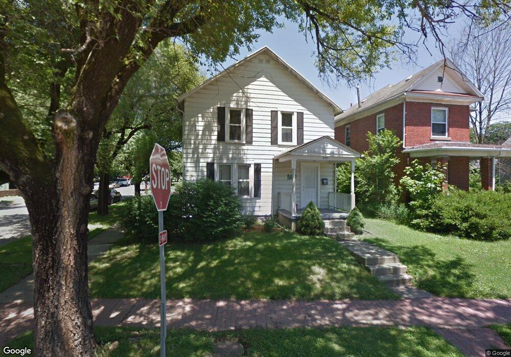
232 W State St Athens, OH 45701
Estimated Value: $188,944 - $214,000
3
Beds
2
Baths
1,328
Sq Ft
$152/Sq Ft
Est. Value
About This Home
This home is located at 232 W State St, Athens, OH 45701 and is currently estimated at $201,486, approximately $151 per square foot. 232 W State St is a home located in Athens County with nearby schools including West Elementary School, Athens Middle School, and Athens High School.
Ownership History
Date
Name
Owned For
Owner Type
Purchase Details
Closed on
Oct 14, 2025
Sold by
Darn Rentals Inc
Bought by
Smallcapdiamondhands Llc
Current Estimated Value
Home Financials for this Owner
Home Financials are based on the most recent Mortgage that was taken out on this home.
Original Mortgage
$260,000
Outstanding Balance
$260,000
Interest Rate
6.5%
Mortgage Type
Credit Line Revolving
Estimated Equity
-$58,514
Purchase Details
Closed on
Jun 7, 2004
Sold by
Stobbart David A
Bought by
Darn Rentals Inc
Purchase Details
Closed on
May 8, 2003
Bought by
Stobart David A
Purchase Details
Closed on
Jun 3, 1998
Sold by
Repp Lantz
Bought by
Darn Rentals Inc
Purchase Details
Closed on
Jun 29, 1992
Sold by
Kerr John Me
Bought by
Repp Lantz
Purchase Details
Closed on
May 1, 1988
Create a Home Valuation Report for This Property
The Home Valuation Report is an in-depth analysis detailing your home's value as well as a comparison with similar homes in the area
Home Values in the Area
Average Home Value in this Area
Purchase History
| Date | Buyer | Sale Price | Title Company |
|---|---|---|---|
| Smallcapdiamondhands Llc | $370,000 | Secured Title | |
| Darn Rentals Inc | -- | -- | |
| Stobart David A | -- | -- | |
| Darn Rentals Inc | $75,900 | -- | |
| Repp Lantz | $45,500 | -- | |
| -- | $43,500 | -- |
Source: Public Records
Mortgage History
| Date | Status | Borrower | Loan Amount |
|---|---|---|---|
| Open | Smallcapdiamondhands Llc | $260,000 |
Source: Public Records
Tax History Compared to Growth
Tax History
| Year | Tax Paid | Tax Assessment Tax Assessment Total Assessment is a certain percentage of the fair market value that is determined by local assessors to be the total taxable value of land and additions on the property. | Land | Improvement |
|---|---|---|---|---|
| 2024 | $3,009 | $53,580 | $5,650 | $47,930 |
| 2023 | $2,805 | $53,580 | $5,650 | $47,930 |
| 2022 | $2,391 | $43,400 | $5,650 | $37,750 |
| 2021 | $2,402 | $43,400 | $5,650 | $37,750 |
| 2020 | $2,335 | $43,400 | $5,650 | $37,750 |
| 2019 | $2,271 | $41,640 | $5,060 | $36,580 |
| 2018 | $2,244 | $41,640 | $5,060 | $36,580 |
| 2017 | $3,708 | $41,640 | $5,060 | $36,580 |
| 2016 | $1,960 | $37,360 | $4,820 | $32,540 |
| 2015 | $3,412 | $37,360 | $4,820 | $32,540 |
| 2014 | $3,412 | $37,360 | $4,820 | $32,540 |
| 2013 | $3,239 | $36,450 | $4,820 | $31,630 |
Source: Public Records
Map
Nearby Homes
- 214 W State St
- 10 1st St
- 56.15/15.5 Central & Clark
- 15 S Shafer St Unit 1509
- 31 1st St
- 98 Central Ave
- 11 Walker St
- 12 Walker St
- 7 Elizabeth Dr
- 0 Roberts St
- 71 W Washington St
- 193 N Lancaster St
- 17 Ring St
- 80 Court
- 64 Franklin Ave
- 131 Grosvenor St
- 550 W Union St
- 115 University Estates Blvd
- 88 University Estates Blvd
- 273 E State St