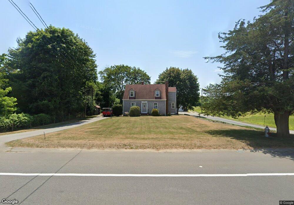
2321 Cranberry Hwy West Wareham, MA 02576
Estimated Value: $459,000 - $556,000
2
Beds
2
Baths
1,422
Sq Ft
$351/Sq Ft
Est. Value
About This Home
This home is located at 2321 Cranberry Hwy, West Wareham, MA 02576 and is currently estimated at $498,499, approximately $350 per square foot. 2321 Cranberry Hwy is a home located in Plymouth County.
Ownership History
Date
Name
Owned For
Owner Type
Purchase Details
Closed on
Jun 18, 2010
Sold by
Churchill Richard M and Churchill Christine M
Bought by
Oheir William P
Current Estimated Value
Home Financials for this Owner
Home Financials are based on the most recent Mortgage that was taken out on this home.
Original Mortgage
$257,531
Outstanding Balance
$170,416
Interest Rate
4.87%
Mortgage Type
FHA
Estimated Equity
$328,083
Purchase Details
Closed on
Dec 18, 2001
Sold by
Florindo Elizabeth K
Bought by
Churchill Richard M and Churchill Christine M
Home Financials for this Owner
Home Financials are based on the most recent Mortgage that was taken out on this home.
Original Mortgage
$200,000
Interest Rate
6.6%
Mortgage Type
Purchase Money Mortgage
Create a Home Valuation Report for This Property
The Home Valuation Report is an in-depth analysis detailing your home's value as well as a comparison with similar homes in the area
Home Values in the Area
Average Home Value in this Area
Purchase History
| Date | Buyer | Sale Price | Title Company |
|---|---|---|---|
| Oheir William P | $261,000 | -- | |
| Oheir William P | $261,000 | -- | |
| Churchill Richard M | $250,000 | -- | |
| Churchill Richard M | $250,000 | -- |
Source: Public Records
Mortgage History
| Date | Status | Borrower | Loan Amount |
|---|---|---|---|
| Open | Oheir William P | $257,531 | |
| Closed | Churchill Richard M | $257,531 | |
| Previous Owner | Churchill Richard M | $25,000 | |
| Previous Owner | Churchill Richard M | $229,000 | |
| Previous Owner | Churchill Richard M | $200,000 |
Source: Public Records
Tax History Compared to Growth
Tax History
| Year | Tax Paid | Tax Assessment Tax Assessment Total Assessment is a certain percentage of the fair market value that is determined by local assessors to be the total taxable value of land and additions on the property. | Land | Improvement |
|---|---|---|---|---|
| 2025 | $4,482 | $430,100 | $112,300 | $317,800 |
| 2024 | $4,333 | $385,800 | $90,100 | $295,700 |
| 2023 | $3,884 | $345,400 | $81,900 | $263,500 |
| 2022 | $3,884 | $294,700 | $81,900 | $212,800 |
| 2021 | $3,845 | $285,900 | $81,900 | $204,000 |
| 2020 | $3,674 | $277,100 | $81,900 | $195,200 |
| 2019 | $3,594 | $270,400 | $86,600 | $183,800 |
| 2018 | $3,365 | $246,900 | $86,600 | $160,300 |
| 2017 | $3,243 | $241,100 | $86,600 | $154,500 |
| 2016 | $3,201 | $236,600 | $90,900 | $145,700 |
| 2015 | $3,092 | $236,600 | $90,900 | $145,700 |
| 2014 | $2,934 | $228,300 | $86,400 | $141,900 |
Source: Public Records
Map
Nearby Homes
- 20 Gault Rd
- 51 Crest Dr
- 103 Castle Dr
- 27 Siesta Dr
- 47 Weaver St
- 41 Longboat Rd
- 11 Acoaxet Ln
- 59 Timber Ln
- 87 Great Hill Dr
- 2230 Cranberry Hwy Unit 1
- 189 Pine View Terrace
- 199 Windswept Rd
- 72 Papermill Rd Unit 72
- 563 County Rd
- 11 Fonseca Way
- 46 Helen St
- 527 High St
- 490 High St
- 19 Station St
- 9 White Pine Ave
- 2327 Cranberry Hwy
- 2322 Cranberry Hwy
- 2319 Cranberry Hwy
- 2329 Cranberry Hwy
- 2326 Cranberry Hwy
- 0 Cranberry Hwy
- 2324 Cranberry Hwy
- 2331 Cranberry Hwy
- 2330 Cranberry Hwy
- 1 Red Oak Terrace
- 2332 Cranberry Hwy
- 2335 Cranberry Hwy
- 171 Monarch Dr
- 2311 Cranberry Hwy
- 153 Monarch Dr
- 2337 Cranberry Hwy
- 33 Gault Rd
- 15 King Dr
- 9 Weaver St
- 170 Monarch Dr