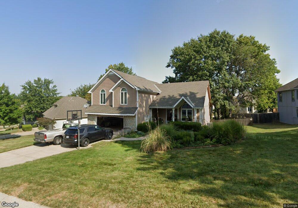
2324 NW Ashurst Dr Lees Summit, MO 64081
Estimated Value: $384,267 - $560,000
3
Beds
3
Baths
2,181
Sq Ft
$207/Sq Ft
Est. Value
About This Home
This home is located at 2324 NW Ashurst Dr, Lees Summit, MO 64081 and is currently estimated at $451,067, approximately $206 per square foot. 2324 NW Ashurst Dr is a home located in Jackson County with nearby schools including Cedar Creek Elementary School, Pleasant Lea Middle School, and Lee's Summit Senior High School.
Ownership History
Date
Name
Owned For
Owner Type
Purchase Details
Closed on
Sep 17, 2001
Sold by
Lewis James W and Lewis Dolores J
Bought by
Stjohn Jason and Stjohn Jill
Current Estimated Value
Home Financials for this Owner
Home Financials are based on the most recent Mortgage that was taken out on this home.
Original Mortgage
$178,624
Outstanding Balance
$69,704
Interest Rate
7%
Mortgage Type
Purchase Money Mortgage
Estimated Equity
$381,363
Purchase Details
Closed on
Jul 29, 1998
Sold by
Thomas Steven R and Thomas Ana C
Bought by
Lewis Christopher C and Lewis Michelle A
Home Financials for this Owner
Home Financials are based on the most recent Mortgage that was taken out on this home.
Original Mortgage
$160,000
Interest Rate
7%
Mortgage Type
Purchase Money Mortgage
Create a Home Valuation Report for This Property
The Home Valuation Report is an in-depth analysis detailing your home's value as well as a comparison with similar homes in the area
Home Values in the Area
Average Home Value in this Area
Purchase History
| Date | Buyer | Sale Price | Title Company |
|---|---|---|---|
| Stjohn Jason | -- | Old Republic Title Company | |
| Lewis James W | -- | Old Republic Title Company | |
| Lewis Christopher C | -- | -- |
Source: Public Records
Mortgage History
| Date | Status | Borrower | Loan Amount |
|---|---|---|---|
| Open | Stjohn Jason | $178,624 | |
| Previous Owner | Lewis Christopher C | $160,000 |
Source: Public Records
Tax History Compared to Growth
Tax History
| Year | Tax Paid | Tax Assessment Tax Assessment Total Assessment is a certain percentage of the fair market value that is determined by local assessors to be the total taxable value of land and additions on the property. | Land | Improvement |
|---|---|---|---|---|
| 2025 | $3,612 | $56,033 | $11,486 | $44,547 |
| 2024 | $3,612 | $50,029 | $7,224 | $42,805 |
| 2023 | $3,586 | $50,029 | $8,029 | $42,000 |
| 2022 | $3,420 | $42,370 | $4,553 | $37,817 |
| 2021 | $3,491 | $42,370 | $4,553 | $37,817 |
| 2020 | $3,523 | $42,336 | $4,553 | $37,783 |
| 2019 | $3,427 | $42,336 | $4,553 | $37,783 |
| 2018 | $3,213 | $36,847 | $3,963 | $32,884 |
| 2017 | $2,910 | $36,847 | $3,963 | $32,884 |
| 2016 | $2,910 | $33,022 | $4,712 | $28,310 |
| 2014 | $2,628 | $37,314 | $5,097 | $32,217 |
Source: Public Records
Map
Nearby Homes
- 505 NW Ambersham Dr
- 130 NW Ambersham Dr
- 361 NW Patch Ct
- 2122 NW Ashurst Dr
- 2090 NW O'Brien Rd
- 2214 NW Killarney Ln
- 2086 NW O'Brien Rd
- 2082 NW O'Brien Rd
- 2110 NW Ashurst Dr
- 2503 NW Windwood Dr
- Monterey Plan at Reserve at Woodside Ridge
- Oakleigh Plan at Reserve at Woodside Ridge
- Ashland Plan at Reserve at Woodside Ridge
- Bentley Plan at Reserve at Woodside Ridge
- Mariah Plan at Reserve at Woodside Ridge
- Oakshire Plan at Reserve at Woodside Ridge
- Forrester II Plan at Reserve at Woodside Ridge
- Forrester 2824 Plan at Reserve at Woodside Ridge
- Regency Plan at Reserve at Woodside Ridge
- Windsong Plan at Reserve at Woodside Ridge
- 2320 NW Ashurst Dr
- 2328 NW Ashurst Dr
- 425 NW Whitlock Dr
- 2321 NW Frances St
- 428 NW Whitlock Dr
- 2316 NW Ashurst Dr
- 2332 NW Ashurst Dr
- 2323 NW Frances St
- 420 NW Essex Dr
- 2317 NW Frances St
- 421 NW Whitlock Dr
- 2325 NW Frances St
- 424 NW Whitlock Dr
- 2313 NW Frances St
- 2327 NW Frances St
- 2312 NW Ashurst Dr
- 416 NW Essex Dr
- 2311 NW Ashurst Dr
- 423 NW Timberbrooke Dr
- 2320 NW Frances St