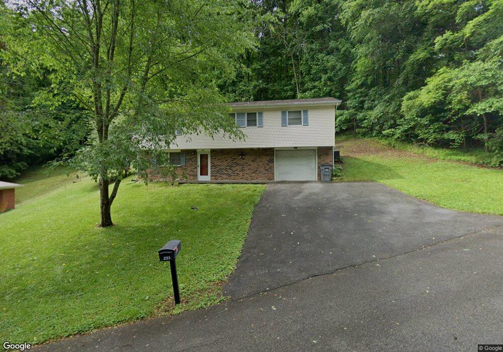
233 Grove Park Dr Bristol, TN 37620
Estimated Value: $228,000 - $247,000
3
Beds
2
Baths
1,566
Sq Ft
$151/Sq Ft
Est. Value
About This Home
This home is located at 233 Grove Park Dr, Bristol, TN 37620 and is currently estimated at $236,454, approximately $150 per square foot. 233 Grove Park Dr is a home located in Sullivan County with nearby schools including Anderson Elementary School, Vance Middle School, and Tennessee High School.
Ownership History
Date
Name
Owned For
Owner Type
Purchase Details
Closed on
Sep 28, 2010
Sold by
Jones James D
Bought by
Meade Elizabeth A
Current Estimated Value
Purchase Details
Closed on
Mar 3, 2007
Sold by
Wells Fargo National Bank
Bought by
Jones James D
Purchase Details
Closed on
Jan 25, 2007
Purchase Details
Closed on
Jan 18, 2005
Sold by
Roe John P and Roe Jane E
Bought by
Fredia Toombs
Home Financials for this Owner
Home Financials are based on the most recent Mortgage that was taken out on this home.
Original Mortgage
$79,200
Interest Rate
5.62%
Create a Home Valuation Report for This Property
The Home Valuation Report is an in-depth analysis detailing your home's value as well as a comparison with similar homes in the area
Home Values in the Area
Average Home Value in this Area
Purchase History
| Date | Buyer | Sale Price | Title Company |
|---|---|---|---|
| Meade Elizabeth A | -- | -- | |
| Jones James D | $89,900 | -- | |
| -- | $11,600 | -- | |
| Fredia Toombs | $88,000 | -- |
Source: Public Records
Mortgage History
| Date | Status | Borrower | Loan Amount |
|---|---|---|---|
| Previous Owner | Fredia Toombs | $79,200 | |
| Previous Owner | Fredia Toombs | $8,800 |
Source: Public Records
Tax History Compared to Growth
Tax History
| Year | Tax Paid | Tax Assessment Tax Assessment Total Assessment is a certain percentage of the fair market value that is determined by local assessors to be the total taxable value of land and additions on the property. | Land | Improvement |
|---|---|---|---|---|
| 2024 | -- | $28,800 | $4,300 | $24,500 |
| 2023 | $1,265 | $28,800 | $4,300 | $24,500 |
| 2022 | $1,265 | $28,800 | $4,300 | $24,500 |
| 2021 | $1,265 | $28,800 | $4,300 | $24,500 |
| 2020 | $1,265 | $28,800 | $4,300 | $24,500 |
| 2019 | $1,265 | $26,750 | $3,725 | $23,025 |
| 2018 | $1,260 | $26,750 | $3,725 | $23,025 |
| 2017 | $1,260 | $26,750 | $3,725 | $23,025 |
| 2016 | $1,162 | $24,075 | $3,725 | $20,350 |
| 2014 | $1,097 | $24,091 | $0 | $0 |
Source: Public Records
Map
Nearby Homes
- 129 Grove Park Dr
- 528 Highway 126
- 113 Neal Dr
- 1323/1385 Island Rd
- 00 Gateway Dr
- 2461 Bradley St
- 2909 Bay St
- 2413 Catherine St
- 2400 Bradley St
- 7006 Gate City Hwy
- 2412,14,16 Bradley St
- 548 Floyd St
- 000 Hemlock Dr
- 124 Boardwalk
- 2241 Bradley St
- 2228 Bay St
- 129 Amhurst Ln
- 2104 Osborne St
- 2177 Randolph St
- 2000 Euclid Ave
- 229 Grove Park Dr
- 237 Grove Park Dr
- 225 Grove Park Dr
- Lot 16 Grove Park Dr
- 223 Grove Park Dr
- 217 Grove Park Dr
- 14 Grove Park Drive Extension
- Lot 17 Grove Park Dr
- 14 Grove Park Dr
- 213 Grove Park Dr
- 330 Pine Circle Dr
- 320 Pine Circle Dr
- 652 Andover Dr
- Tbd Andover Dr
- 244 Pine Circle Dr
- 70 Pine Circle Dr
- 261 Grove Park Dr
- 222 Grove Park Dr
- 0000 Grove Park Dr
- TBA Grove Park Dr