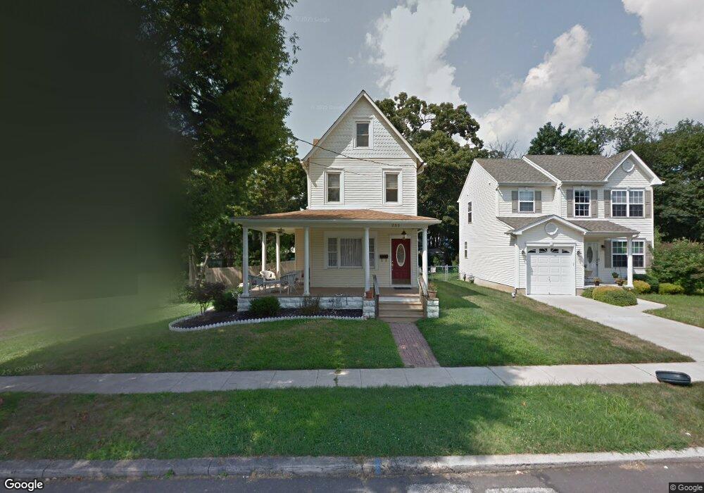
233 Lincoln Ave Magnolia, NJ 08049
Estimated Value: $334,000 - $365,000
--
Bed
--
Bath
1,705
Sq Ft
$203/Sq Ft
Est. Value
About This Home
This home is located at 233 Lincoln Ave, Magnolia, NJ 08049 and is currently estimated at $346,329, approximately $203 per square foot. 233 Lincoln Ave is a home located in Camden County with nearby schools including Magnolia Elementary School and Sterling High School.
Ownership History
Date
Name
Owned For
Owner Type
Purchase Details
Closed on
Mar 25, 2009
Sold by
Sochanchak Nicholas
Bought by
Barberi Carl and Barberi Lisa
Current Estimated Value
Home Financials for this Owner
Home Financials are based on the most recent Mortgage that was taken out on this home.
Original Mortgage
$215,710
Outstanding Balance
$135,775
Interest Rate
4.94%
Mortgage Type
FHA
Estimated Equity
$210,554
Purchase Details
Closed on
Jun 26, 2007
Sold by
Sochanchak Nicholas
Bought by
Sochanchak Nicholas
Create a Home Valuation Report for This Property
The Home Valuation Report is an in-depth analysis detailing your home's value as well as a comparison with similar homes in the area
Home Values in the Area
Average Home Value in this Area
Purchase History
| Date | Buyer | Sale Price | Title Company |
|---|---|---|---|
| Barberi Carl | $220,000 | -- | |
| Sochanchak Nicholas | -- | -- |
Source: Public Records
Mortgage History
| Date | Status | Borrower | Loan Amount |
|---|---|---|---|
| Open | Barberi Carl | $215,710 |
Source: Public Records
Tax History Compared to Growth
Tax History
| Year | Tax Paid | Tax Assessment Tax Assessment Total Assessment is a certain percentage of the fair market value that is determined by local assessors to be the total taxable value of land and additions on the property. | Land | Improvement |
|---|---|---|---|---|
| 2025 | $7,129 | $148,500 | $43,600 | $104,900 |
| 2024 | $6,956 | $148,500 | $43,600 | $104,900 |
| 2023 | $6,956 | $148,500 | $43,600 | $104,900 |
| 2022 | $6,775 | $148,500 | $43,600 | $104,900 |
| 2021 | $6,709 | $148,500 | $43,600 | $104,900 |
| 2020 | $6,582 | $148,500 | $43,600 | $104,900 |
| 2019 | $6,457 | $148,500 | $43,600 | $104,900 |
| 2018 | $6,326 | $148,500 | $43,600 | $104,900 |
| 2017 | $6,142 | $148,500 | $43,600 | $104,900 |
| 2016 | $5,970 | $148,500 | $43,600 | $104,900 |
| 2015 | $5,763 | $148,500 | $43,600 | $104,900 |
| 2014 | $5,682 | $148,500 | $43,600 | $104,900 |
Source: Public Records
Map
Nearby Homes
- 207 NE Atlantic Ave
- 430 Brooke Ave
- 130 W Monroe Ave
- 115 Phillips Ave
- 130 E Evesham Ave
- 431 N White Horse Pike
- 322 W Washington Ave
- 606 Lincoln Ave
- 121 Lafayette Ave
- 114 Jefferson Ave
- 313 E Washington Ave
- 26 Center Oak Ave
- 22 Center Oak Ave
- 59 E Oak Ave
- 319 Magnolia Ave
- 13 Malibu Dr
- 539 Fresno Dr
- 172 E Charleston Ave
- 178 E Charleston Ave
- 128 E Oak Ave
- 233 W Lincoln Ave
- 231 W Lincoln Ave
- 231 Lincoln Ave
- 235 Lincoln Ave
- 235 W Lincoln Ave
- 409 NE Atlantic Ave
- 224 Brooke Ave
- 226 Brooke Ave
- 223 W Lincoln Ave
- 223 Lincoln Ave
- 230 Lincoln Ave
- 222 Brooke Ave
- 219 Lincoln Ave
- 228 Brooke Ave
- 315 NE Atlantic Ave
- 224 Lincoln Ave
- 309 NE Atlantic Ave
- 218 Lincoln Ave
- 213 Lincoln Ave
- 214 Lincoln Ave