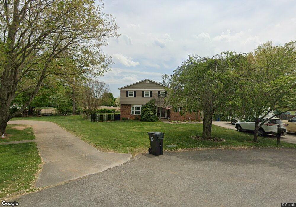
2331 Pennell Cir Morristown, TN 37814
Estimated Value: $286,655 - $383,000
--
Bed
3
Baths
2,178
Sq Ft
$161/Sq Ft
Est. Value
About This Home
This home is located at 2331 Pennell Cir, Morristown, TN 37814 and is currently estimated at $350,164, approximately $160 per square foot. 2331 Pennell Cir is a home located in Hamblen County with nearby schools including West Elementary School, Lincoln Heights Middle School, and Morristown West High School.
Ownership History
Date
Name
Owned For
Owner Type
Purchase Details
Closed on
Aug 3, 2011
Bought by
Blackerby Ritchie & Carolyn Blackerby Trust
Current Estimated Value
Purchase Details
Closed on
Jul 31, 1987
Bought by
Blackerby Ritchie T and Blackerby Carolyn B
Purchase Details
Closed on
Jul 22, 1987
Bought by
Realty House Inc The
Purchase Details
Closed on
Sep 16, 1968
Bought by
Pemberton James P and Beverly B Apt #
Create a Home Valuation Report for This Property
The Home Valuation Report is an in-depth analysis detailing your home's value as well as a comparison with similar homes in the area
Home Values in the Area
Average Home Value in this Area
Purchase History
| Date | Buyer | Sale Price | Title Company |
|---|---|---|---|
| Blackerby Ritchie & Carolyn Blackerby Trust | -- | -- | |
| Blackerby Ritchie T | $65,000 | -- | |
| Realty House Inc The | $65,000 | -- | |
| Pemberton James P | -- | -- |
Source: Public Records
Tax History Compared to Growth
Tax History
| Year | Tax Paid | Tax Assessment Tax Assessment Total Assessment is a certain percentage of the fair market value that is determined by local assessors to be the total taxable value of land and additions on the property. | Land | Improvement |
|---|---|---|---|---|
| 2024 | $728 | $41,350 | $7,900 | $33,450 |
| 2023 | $735 | $41,775 | $0 | $0 |
| 2022 | $1,320 | $41,775 | $7,900 | $33,875 |
| 2021 | $1,320 | $41,775 | $7,900 | $33,875 |
| 2020 | $1,318 | $41,775 | $7,900 | $33,875 |
| 2019 | $1,106 | $32,525 | $7,750 | $24,775 |
| 2018 | $1,025 | $32,525 | $7,750 | $24,775 |
| 2017 | $977 | $31,525 | $7,750 | $23,775 |
| 2016 | $933 | $31,525 | $7,750 | $23,775 |
| 2015 | $868 | $31,525 | $7,750 | $23,775 |
| 2014 | -- | $31,525 | $7,750 | $23,775 |
| 2013 | -- | $33,575 | $0 | $0 |
Source: Public Records
Map
Nearby Homes
- 2310 Sandstone Dr
- 2045 N Economy Rd Unit A3
- 2444 Sandstone Dr
- 2454 Sandstone Dr
- 2430 Sandstone Dr
- 2020 N Economy Rd
- 707 Walters Dr
- 941 Heykoop Dr
- 1033 Walters Dr
- 1442 Darbee Dr
- 1626 Cardinal Dr
- 1613 Cardinal Dr
- 729 Amanda Harrison Ct
- 3113 Wilshire Blvd
- 2978 Wilshire Blvd
- 1476 Darbee Dr
- 1530 Rayburn Dr
- 1230 Mcfarland St Unit 3
- 1230 Mcfarland St Unit 37
- 801 Colonial Dr
- 2330 Pennell Cir
- 710 Masengill Ave
- 2334 Pennell Cir
- 716 Masengill Ave
- 2141 N Economy Rd
- 616 Masengill Ave
- 703 Masengill Ave
- 707 Masengill Ave
- 2145 N Economy Rd
- 615 Masengill Ave
- 722 Masengill Ave
- 717 Masengill Ave
- 2136 Collins St
- 2149 N Economy Rd
- 2130 Collins St
- TBD N Economy Rd
- 2124 Collins St
- 700 Shockley Ave
- 605 Masengill Ave
- 723 Masengill Ave