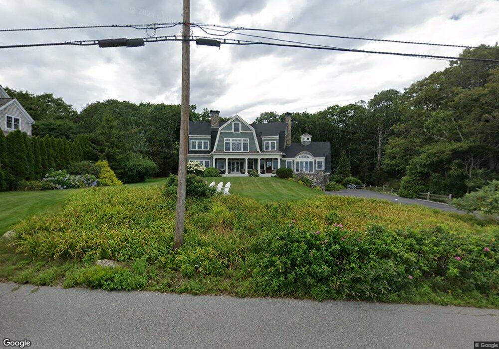
234 Ocean Ave Kennebunkport, ME 04046
Estimated Value: $3,555,000 - $5,388,463
5
Beds
5
Baths
4,796
Sq Ft
$955/Sq Ft
Est. Value
About This Home
This home is located at 234 Ocean Ave, Kennebunkport, ME 04046 and is currently estimated at $4,581,488, approximately $955 per square foot. 234 Ocean Ave is a home located in York County with nearby schools including Kennebunk High School.
Ownership History
Date
Name
Owned For
Owner Type
Purchase Details
Closed on
Oct 17, 2008
Sold by
Brodowski Alex T and Brodowski Kathleen M
Bought by
Oceans 7 Llc
Current Estimated Value
Purchase Details
Closed on
May 1, 2006
Sold by
Dennis Robert W and Dennis Joan L
Bought by
Brodowski Alex T and Brodowski Kathline M
Home Financials for this Owner
Home Financials are based on the most recent Mortgage that was taken out on this home.
Original Mortgage
$1,000,000
Interest Rate
6%
Mortgage Type
Adjustable Rate Mortgage/ARM
Create a Home Valuation Report for This Property
The Home Valuation Report is an in-depth analysis detailing your home's value as well as a comparison with similar homes in the area
Home Values in the Area
Average Home Value in this Area
Purchase History
| Date | Buyer | Sale Price | Title Company |
|---|---|---|---|
| Oceans 7 Llc | -- | -- | |
| Brodowski Alex T | -- | -- |
Source: Public Records
Mortgage History
| Date | Status | Borrower | Loan Amount |
|---|---|---|---|
| Previous Owner | Oceans 7 Llc | $415,000 | |
| Previous Owner | Brodowski Alex T | $1,000,000 |
Source: Public Records
Tax History
| Year | Tax Paid | Tax Assessment Tax Assessment Total Assessment is a certain percentage of the fair market value that is determined by local assessors to be the total taxable value of land and additions on the property. | Land | Improvement |
|---|---|---|---|---|
| 2025 | $23,248 | $3,379,000 | $2,203,000 | $1,176,000 |
| 2024 | $21,964 | $3,379,000 | $2,203,000 | $1,176,000 |
| 2023 | $21,119 | $3,379,000 | $2,203,000 | $1,176,000 |
| 2022 | $20,211 | $3,368,500 | $2,203,000 | $1,165,500 |
| 2021 | $22,572 | $2,351,200 | $1,369,100 | $982,100 |
| 2020 | $22,219 | $2,351,200 | $1,369,100 | $982,100 |
| 2019 | $22,217 | $2,351,000 | $1,369,100 | $981,900 |
| 2018 | $15,113 | $2,351,000 | $1,369,100 | $981,900 |
| 2017 | $20,454 | $2,351,000 | $1,369,100 | $981,900 |
| 2016 | $19,466 | $2,351,000 | $1,369,100 | $981,900 |
| 2015 | $18,103 | $2,351,000 | $1,369,100 | $981,900 |
| 2014 | $17,938 | $2,351,000 | $1,369,100 | $981,900 |
Source: Public Records
Map
Nearby Homes
- 51 Woodland Dr
- 2A Ivy Ln
- Lot 2 Woodland Dr
- 17 Seaview Ave
- 298 Ocean Ave
- 47 Maine St Unit 4
- 60 Ocean Ave
- 5 Creekside Unit 3
- 47 Ocean Ave Unit 8
- 143 Beach Ave Unit 205
- 143 Beach Ave Unit 203
- 7 Saddle Way
- 24 School St
- 12 Beach Ave
- 20 Surf Ln
- 3 Mckenney Ln
- 7 Christensen Ln
- 16 Larboard Ln Unit 6
- 3 Breakwater Ct Unit 1
- 11 Harbor Dr
Your Personal Tour Guide
Ask me questions while you tour the home.