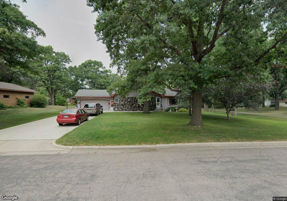
235 10th St N Sauk Rapids, MN 56379
Estimated Value: $278,000 - $307,000
3
Beds
3
Baths
2,480
Sq Ft
$119/Sq Ft
Est. Value
About This Home
This home is located at 235 10th St N, Sauk Rapids, MN 56379 and is currently estimated at $295,367, approximately $119 per square foot. 235 10th St N is a home located in Benton County with nearby schools including Pleasant View Elementary School, Sauk Rapids-Rice Middle School, and Sauk Rapids-Rice Senior High School.
Ownership History
Date
Name
Owned For
Owner Type
Purchase Details
Closed on
Aug 30, 2021
Sold by
Dyrland Beverly E and Dyrland Patrick E
Bought by
Vievering Michael W and Vievering Joan M
Current Estimated Value
Home Financials for this Owner
Home Financials are based on the most recent Mortgage that was taken out on this home.
Original Mortgage
$185,600
Outstanding Balance
$168,630
Interest Rate
2.7%
Mortgage Type
New Conventional
Estimated Equity
$126,737
Create a Home Valuation Report for This Property
The Home Valuation Report is an in-depth analysis detailing your home's value as well as a comparison with similar homes in the area
Home Values in the Area
Average Home Value in this Area
Purchase History
| Date | Buyer | Sale Price | Title Company |
|---|---|---|---|
| Vievering Michael W | $232,000 | Tri County Abst | |
| Vievering Michael Michael | $232,000 | -- |
Source: Public Records
Mortgage History
| Date | Status | Borrower | Loan Amount |
|---|---|---|---|
| Open | Vievering Michael W | $185,600 | |
| Closed | Vievering Michael Michael | $232,000 |
Source: Public Records
Tax History Compared to Growth
Tax History
| Year | Tax Paid | Tax Assessment Tax Assessment Total Assessment is a certain percentage of the fair market value that is determined by local assessors to be the total taxable value of land and additions on the property. | Land | Improvement |
|---|---|---|---|---|
| 2025 | $3,076 | $270,100 | $35,700 | $234,400 |
| 2024 | $3,056 | $258,700 | $35,700 | $223,000 |
| 2023 | $2,936 | $262,300 | $35,700 | $226,600 |
| 2022 | $2,752 | $232,900 | $32,400 | $200,500 |
| 2021 | $2,512 | $201,900 | $32,400 | $169,500 |
| 2018 | $2,112 | $147,000 | $27,138 | $119,862 |
| 2017 | $2,112 | $127,500 | $26,327 | $101,173 |
| 2016 | $2,064 | $147,900 | $31,200 | $116,700 |
| 2015 | $2,080 | $114,100 | $25,648 | $88,452 |
| 2014 | -- | $107,700 | $25,265 | $82,435 |
| 2013 | -- | $103,000 | $24,970 | $78,030 |
Source: Public Records
Map
Nearby Homes
- 314 Pleasant Ridge Dr
- 1018 N Benton Dr
- 702 N Benton Dr
- 709 N Benton Dr
- 224 9th St N
- 18th 18th
- 615 3rd Ave N
- 390 18th Street Ct NW
- 870 18th St NW
- 820 18th St NW
- 32608 River Vista Ln
- 752 12th St N
- 32467 County Road 1
- 1101 10th Ave N
- 1107 10th Ave N
- 1201 10th Ave N
- 1809 Eastern Star Loop
- 1914 N Benton Dr
- 1804 Oak Pond Dr
- 1209 Oak Pond Dr